January 6, 2019 – Garrison, NY
Difficulty: Easy – moderate
Length: Approximately 2.6 miles
Max elevation: 640 ft. – total elevation gain: approximately 617 ft.
Route type: Circuit
Map: East Hudson Trails Map #101 – Free Web Map
Trailhead parking: 584 NY-9D, Garrison, NY 10524
Overview:
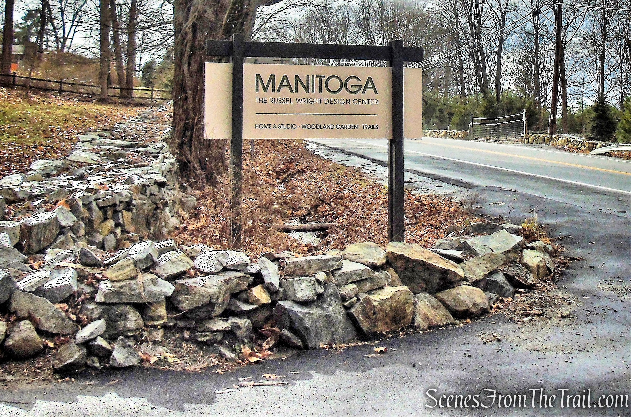
Located in Garrison, New York, approximately one hour north of New York City, Manitoga is the House, Studio and 75-acre woodland garden of American industrial designer Russel Wright (1904-1976). Manitoga is a National Historic Landmark, an Affiliate Site of the National Trust for Historic Preservation, and one of the few 20th century modern homes with original landscape open to the public.
Over 70 years ago, Russel and Mary Wright acquired an abandoned quarry and surrounding hillside in the Lower Hudson Valley, and he slowly restored this land to a place of extraordinary beauty. Inspired by the legacy of the Wappinger people, the ancestral residents of the area, Wright called the emerging vision for these 75 acres “Manitoga” or Place of Great Spirit.
MANITOGA
The Trails:
The trails offer opportunities for moderate loop hikes of varying distances on the west facing slopes as well as access to extended hiking on the Osborn Loop Trail and Appalachian Trail in the adjacent Hudson Highlands State Park. In the summer there are pocket views of the Hudson River. These are called “osios” at Manitoga, from the language of the Iroquois.
Three trail loops, named for an historic trail segment, story, or event unique to that loop are marked with blue, red, or white markers.
The trails are co-aligned, following a single path from the start, with the Wickopee Trail Loop (Red) first peeling off to a short inner loop; then the White Pine Trail Loop (White): and finally, the Lost Pond Trail Loop (Blue) extending up the hill to an elevation of 650’ (400’ above the start). Loops reunite at Four Corners and are co-aligned for the descent to the meadow origin.
Wickopee Trail Loop – Red Blazes
.74 miles 45 min.
– easy hike on Wickopee Trail includes Log Bridge stream crossing
White Pine Trail Loop – White Blazes
1.1 miles 1 hr.
– easy to moderate hike follows White Pine Path along the top of a great cliff; over a boulder stream crossing; past the fallen, giant white pine to Deer Pool; and through Fern Meadow
Lost Pond Trail Loop – Blue Blazes
1.5 miles 1-1/2 hrs.
– moderate hike crosses streams on boulder stepping stones and ascends to Lost Pond
– access to 3 view spots: Mossy Overlook, Lost Pond Osio, and Chestnut Ridge Osio
– connects to Osborn Loop and Appalachian Trail
Trails to View Spots and at connecting trail – Yellow Blazes
Trail to Sunset Osio .03 miles
Trail to Chestnut Oak Ridge Osio .16 miles
Osborn Loop & AT connecting trail at Lost Pond .12 miles
In keeping with Wright’s original plan, all his trails were designed to be hiked in one direction; trail blazes reinforce that intention by being single colored in one direction, and the same color but with a black dot in the reverse direction.
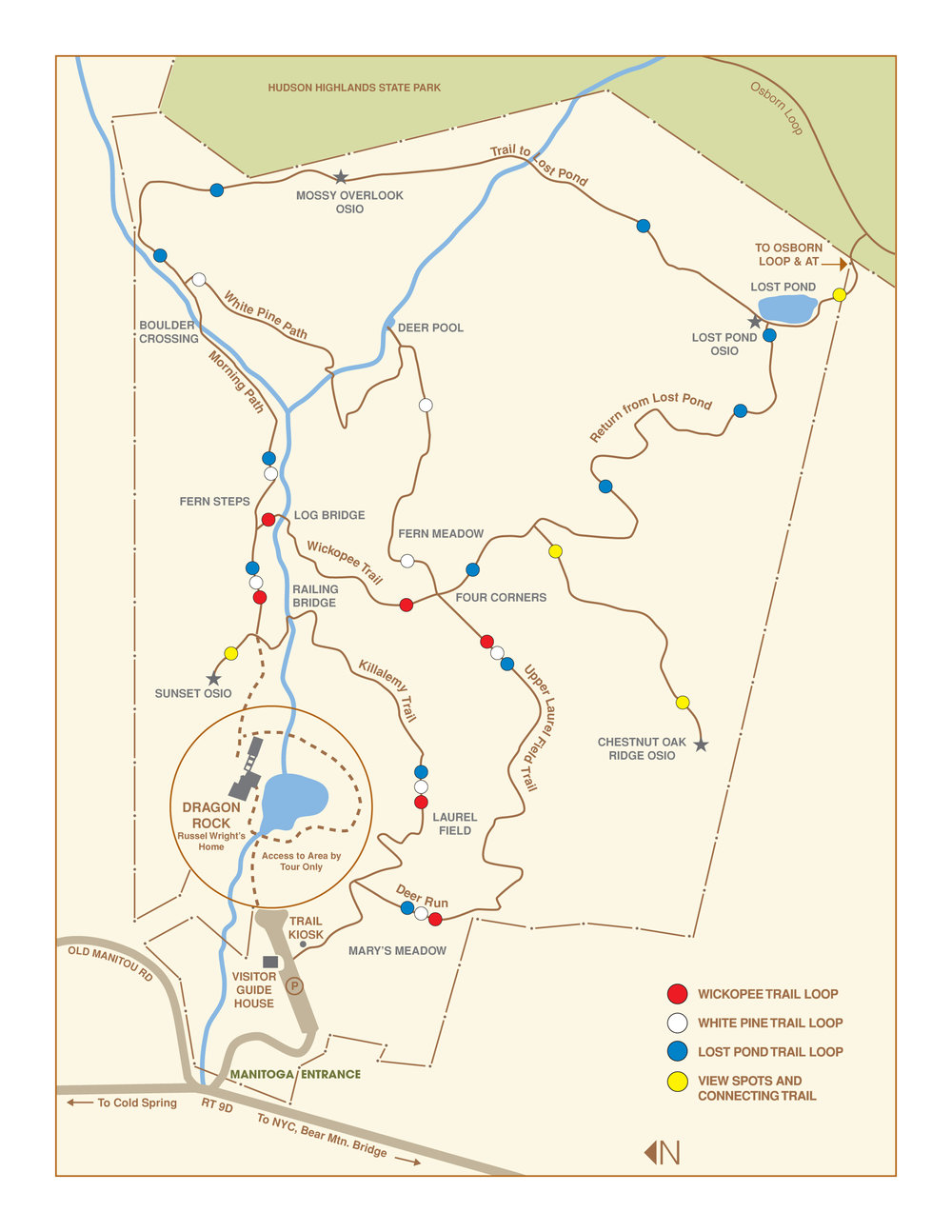
MANITOGA Trail Map
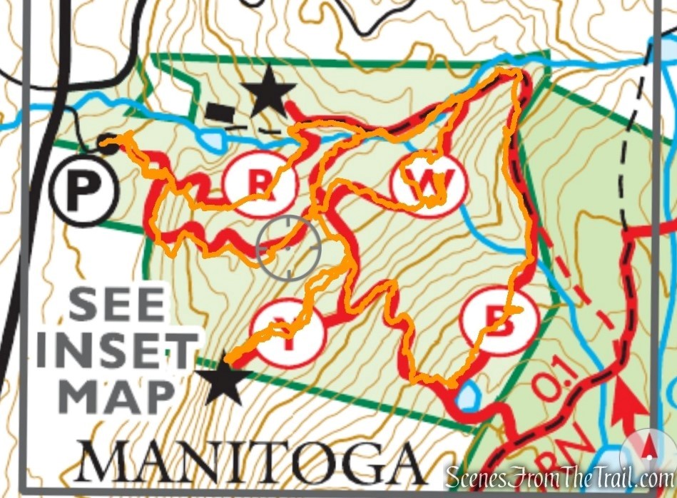
The hike:
The three main trails on the property, which are are laid out ladder-like up the hill toward Lost Pond, are intended to be hiked in a clockwise direction. Although they are also blazed in the other direction, those blazes have a black dot in the middle, indicating that this is not the preferred direction of travel. This hike follows the trails in a clockwise direction, but you will notice blazes with black dots when you retrace your steps on side trails that lead to viewpoints. This hike covers all of the main trails on the property.
MANITOGA
After stopping at the Guide House to register, head uphill on a wood-chip road. Turn left at a sign for “TRAILS,” then turn left again at a larger sign. You’ll be following the blue-blazed Lost Pond Trail Loop, but at first, this trail is co-aligned with the red-blazed Wickopee Trail Loop and the white-blazed White Pine Trail Loop.
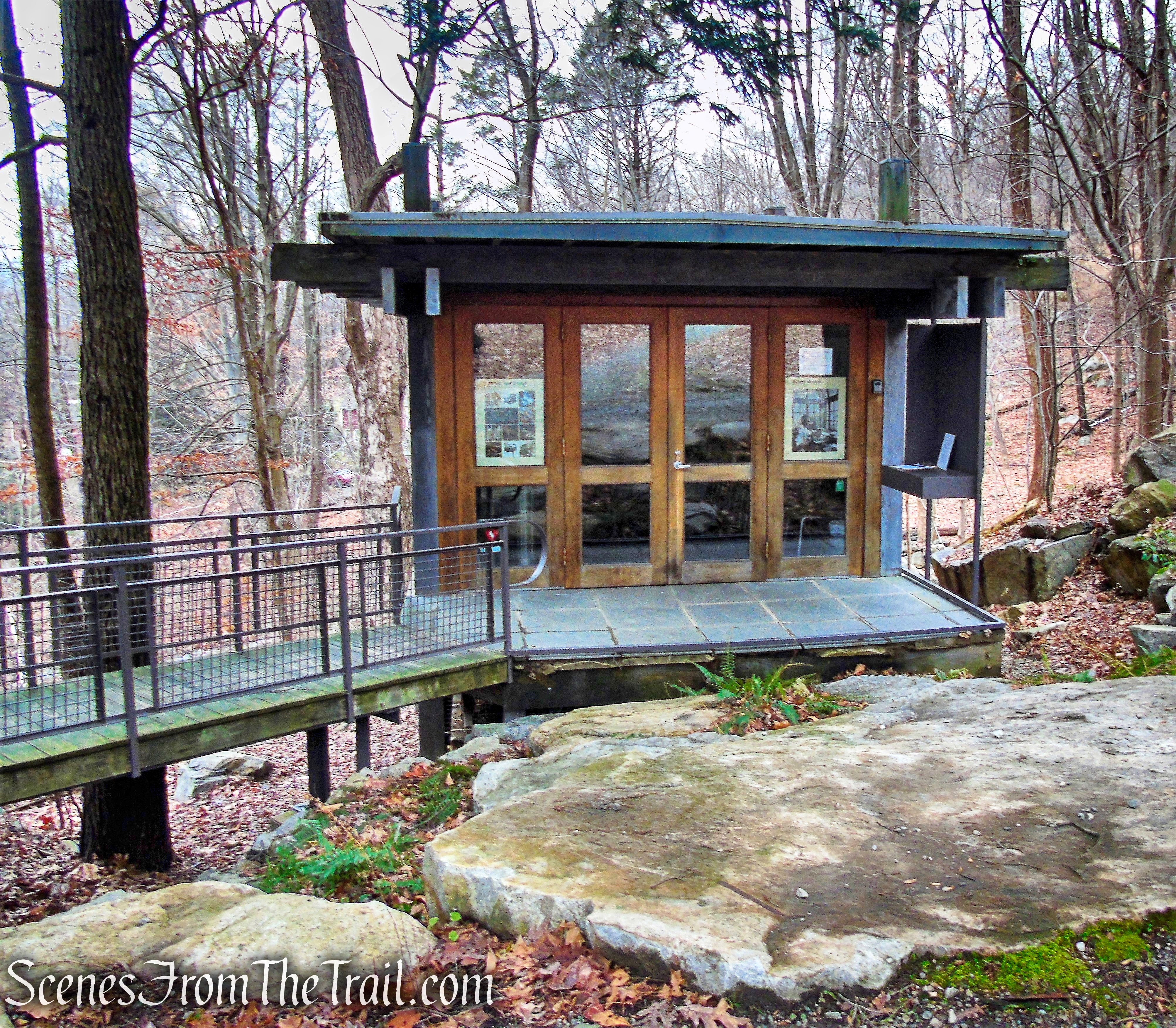
Guide House – MANITOGA
MANITOGA
Killalemy Trail – MANITOGA
Follow the trail, marked with white, red and blue blazes, as it climbs on stone steps and switchbacks. After passing through mountain laurel thickets, the trail goes between two large boulders and levels off. It then descends a little to cross a wooden bridge over a stream. The trail now turns sharply left to briefly parallel the stream, then curves to the right.
Killalemy Trail
Killalemy Trail – MANITOGA
Killalemy Trail – MANITOGA
railing bridge – MANITOGA
Just beyond, a triple-yellow blaze marks the start of a short side trail that goes off to the left to a viewpoint known as the Sunset Osio. The view from this location is very limited when there are leaves on the trees, but the short side trip is worthwhile, as there are two interesting boulders at the end of the yellow-blazed side trail.
Please note: The sign pictured below is adjacent to the start of the Yellow Trail described above. We took that to mean that the Yellow Trail was off limits, so we skipped it. The sign refers only to the woods road that is behind the sign and not the marked trail.
MANITOGA
Return to the main trail and turn left. You now head uphill on an old woods road. Soon, the red-blazed Wickopee Trail Loop leaves to the right, but you should continue ahead, now following white and blue blazes.
Killalemy Trail – MANITOGA
stay left when Red Trail leaves to the right
now following white and blue blazes
A short distance beyond, you’ll cross a stream on rocks opposite a cliff.
cross a stream on rocks
Next, the white-blazed White Pine Trail Loop goes off to the right. Continue ahead, now following only blue blazes.
white-blazed White Pine Trail Loop goes off to the right
now following only blue blazes
The trail curves to the right and continues to ascend. Along the way, a yellow blaze on the right of the trail marks the Mossy Overlook Osio, a limited viewpoint from which you can see across the Hudson River.
Mossy Overlook Osio
Mossy Overlook Osio
A short distance beyond, you’ll reach a junction where a sign indicates that the Osborn Loop is to the left. Continue ahead on the blue-blazed trail, following the sign for “Lost Pond.” The trail now crosses a stream and continues to ascend.
Lost Pond Trail Loop
Lost Pond Trail Loop
Lost Pond Trail Loop
After passing through dense mountain laurel thickets, you’ll reach Lost Pond. At the southern end of the pond, a yellow blaze on the right marks the Lost Pond Osio, another limited viewpoint over the Hudson River, and a triple-yellow blaze on the left marks the start of a connecting trail that leads to the Osborn Loop.
Lost Pond Trail Loop
Lost Pond
Lost Pond Osio
connecting trail that leads to the Osborn Loop
Here, you should turn right and follow the blue-blazed Lost Pond Trail Loop downhill.
Lost Pond Trail Loop
About halfway down, you’ll notice a triple-yellow blaze on the left. Turn left and follow this yellow-blazed side trail to the Chestnut Oak Ridge Osio, a panoramic viewpoint over the Hudson River (the best view is a short distance beyond the triple blaze that marks the official end of this side trail).
Turn left and follow this yellow-blazed side trail
Chestnut Oak Ridge Osio
Chestnut Oak Ridge Osio
After taking in the view, retrace your steps to the blue-blazed trail, turn left and continue heading downhill.
retrace your steps on yellow-blazed trail
Lost Pond Trail Loop
A short distance beyond, you’ll come to the Four Corners, where the blue-blazed Lost Pond Trail Loop turns left and joins the white and red trails.
Four Corners
Proceed ahead on the red-blazed Wickopee Trail, which will be followed with the black dot in the middle.
Wickopee Trail
The red blazes head downhill in a westerly direction.
Wickopee Trail
The Wickopee Trail then crosses a stream on a log bridge.
log bridge – Wickopee Trail
After crossing the stream, turn right, leaving the red-blazed trail and now following the blue and white blazes. In a short distance recross the stream on rocks. This short section between the two stream crossings is a repeat from earlier in the hike.
now following white and blue blazes
A short distance after crossing the stream, the White Pine Trail leaves to the right. Turn right and follow the white blazes as they lead uphill.
White Pine Trail
White Pine Trail
Follow the white blazes along the top of a cliff, over a boulder stream crossing, to Deer Pool and through Fern Meadow.
White Pine Trail
stream crossing – White Pine Trail
Deer Pool – White Pine Trail
Deer Pool – White Pine Trail
White Pine Trail
The white blazes pass through the Four Corners and join the red and blue blazes. Continue downhill, now following the trail marked with white, red and blue blazes.
Upper Laurel Field Trail
The trail heads downhill, turns right and comes to a T-intersection. Turn left and follow the wood chip path back to the parking area, where the hike began.
Upper Laurel Field Trail
Review:
This preserve is surprisingly rugged and the trails are well blazed. The property is quite scenic and the numerous stream crossings make for a fun hike. The three loop trails along varied terrain make any number of loop hikes possible for the seasoned hiker or the novice. A nice way to spend a few hours in the Hudson Valley.
Pros: Well blazed trails, cascading streams, varied terrain, scenic landscape.
Cons: Scenic viewpoints are not impressive, trails get swampy after heavy or prolonged rainfall.
Take a hike!
MANITOGA
Sources:
