Please Note: An updated version of this hike is available here: Pine Swamp Short Loop – 2026.
November 23, 2018 – Southfields, NY
Difficulty: Easy
Length: approximately 3.7 miles
Max elevation: 1,180 ft.– total elevation gain 522 ft.
Route type: Circuit
Map: Harriman-Bear Mountain Trails Map #119
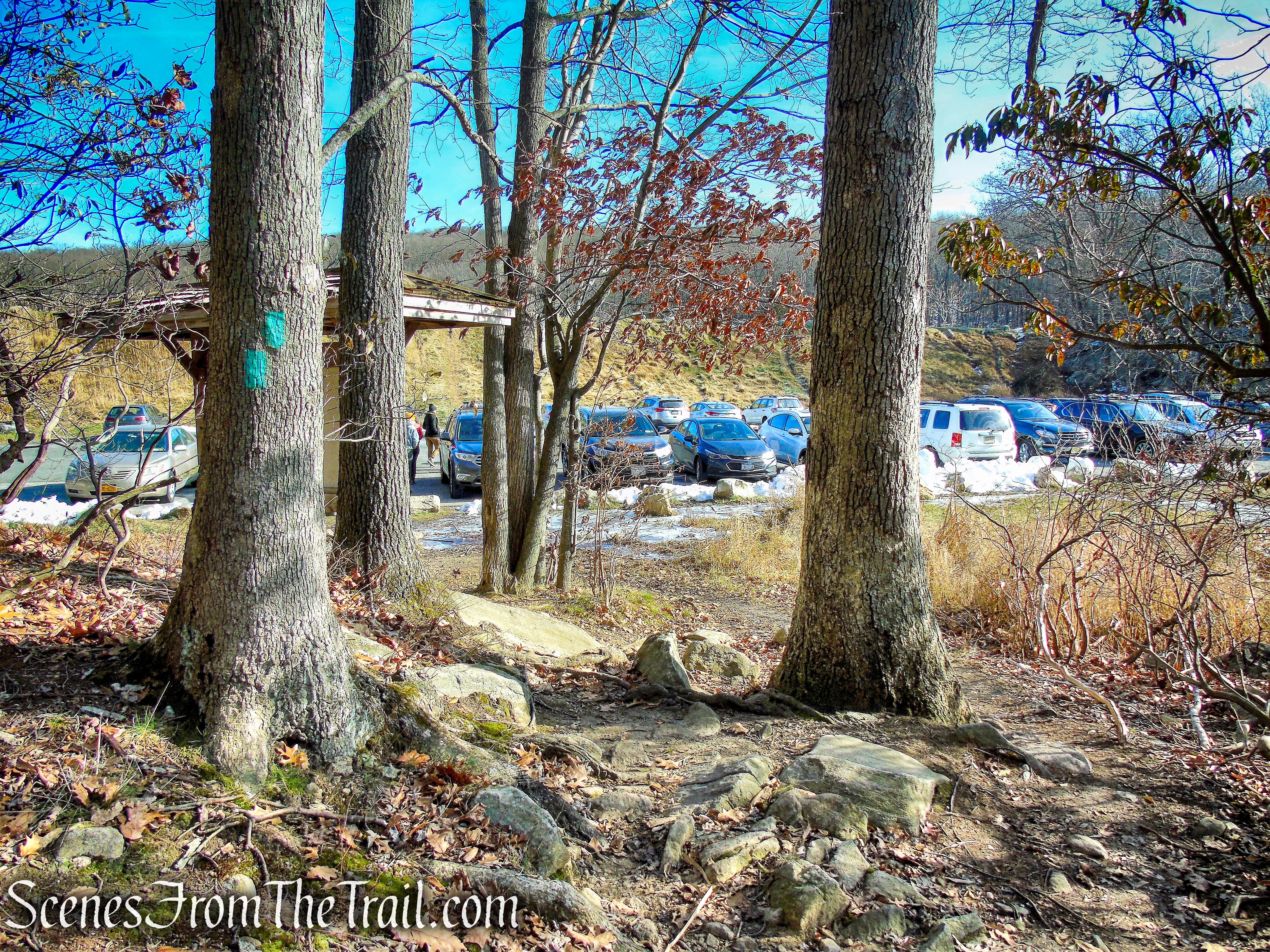
Trailhead parking: Lake Skanatati Parking – Southfields, NY 10975
Click here to see Trail Alerts for Bear Mountain-Harriman State Parks
Please note: Hikers should use caution in the vicinity of the mines, as their deep, water filled pits and unstable overhanging rocks can be dangerous.
This hike was done on Black Friday and while the masses were in the malls, we were on the trails. It was a bitter cold morning, in the low 20’s, so we got a late start hoping for the temperature to rise a few degrees. Upon arriving at the trailhead parking at Lake Skannatati just before 11:00 am, there were only a few cars in the lot. In the warmer months, this parking lot fills up by early morning.
This hike was done in a counterclockwise fashion from the Lake Skannatati parking lot. If not for the missed turn on the easy bushwack, the hike would be closer to 3 miles. Even though I had done the same bushwack several times, I didn’t recognize the spot to leave the trail due to snow on the ground.
A longer similar version of this hike can be viewed HERE.
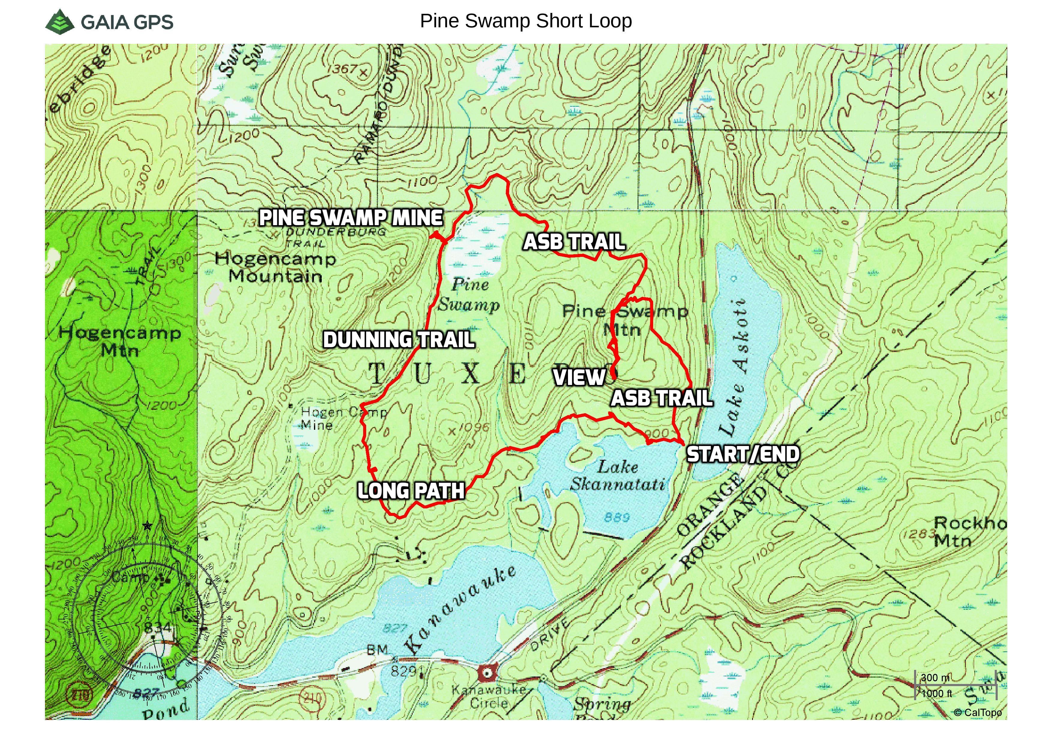
Pine Swamp Short Loop
The hike:
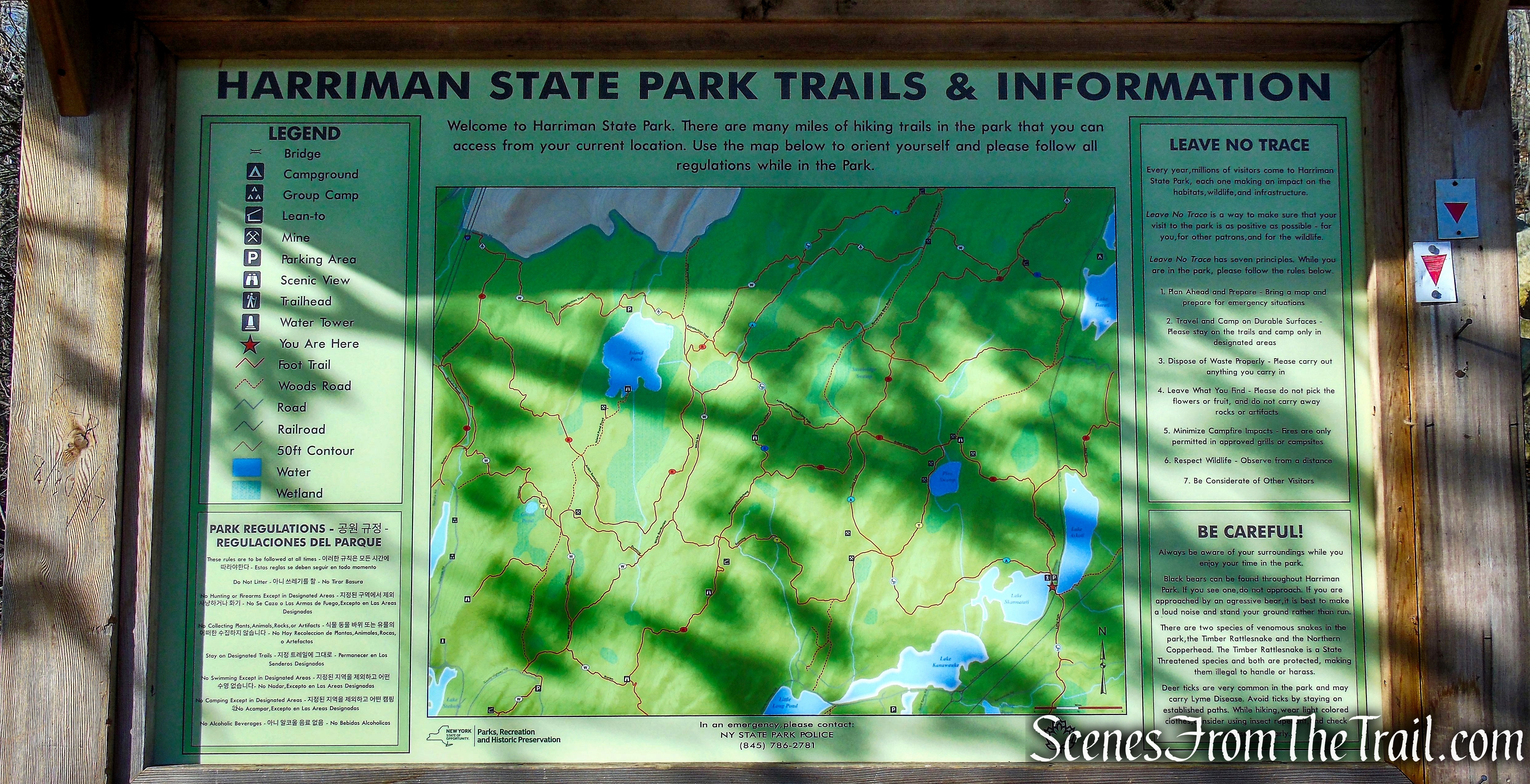
At the northwest end of the parking area, to the right of the kiosk, is the start of the inverted-red-triangle-on-white blazed Arden-Surebridge (A-SB) Trail. To the left of the kiosk is the aqua-blazed Long Path which would be our return route.
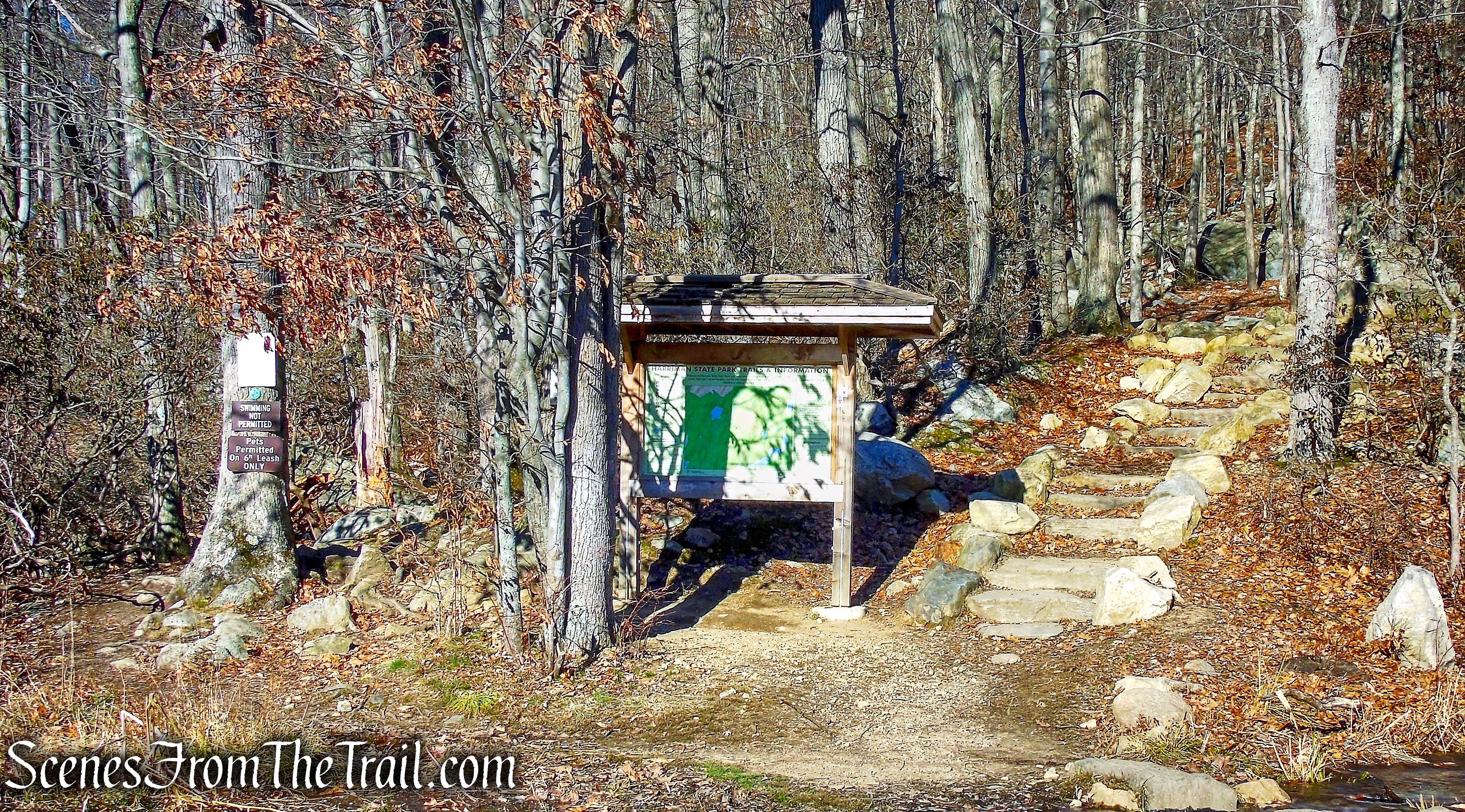
Arden-Surebridge (A-SB) Trailhead
The kiosk has a large map of the area, but it is a good idea to have an updated paper map along on the hike, as well as a compass. The NY/NJ Trail Conference has an updated 2018 Harriman-Bear Mountain Trails Map for sale. It’s totally worth the price. I was using an outdated map from 2015 and ran into a little confusion on several hikes where trails were rerouted. It’s also a good idea to check for trail conditions as well, in case there are issues where you plan to hike.
Arden-Surebridge (A-SB) Trailhead
The A-SB Trail begins a rather steep climb along the shoulder of Pine Swamp Mountain.
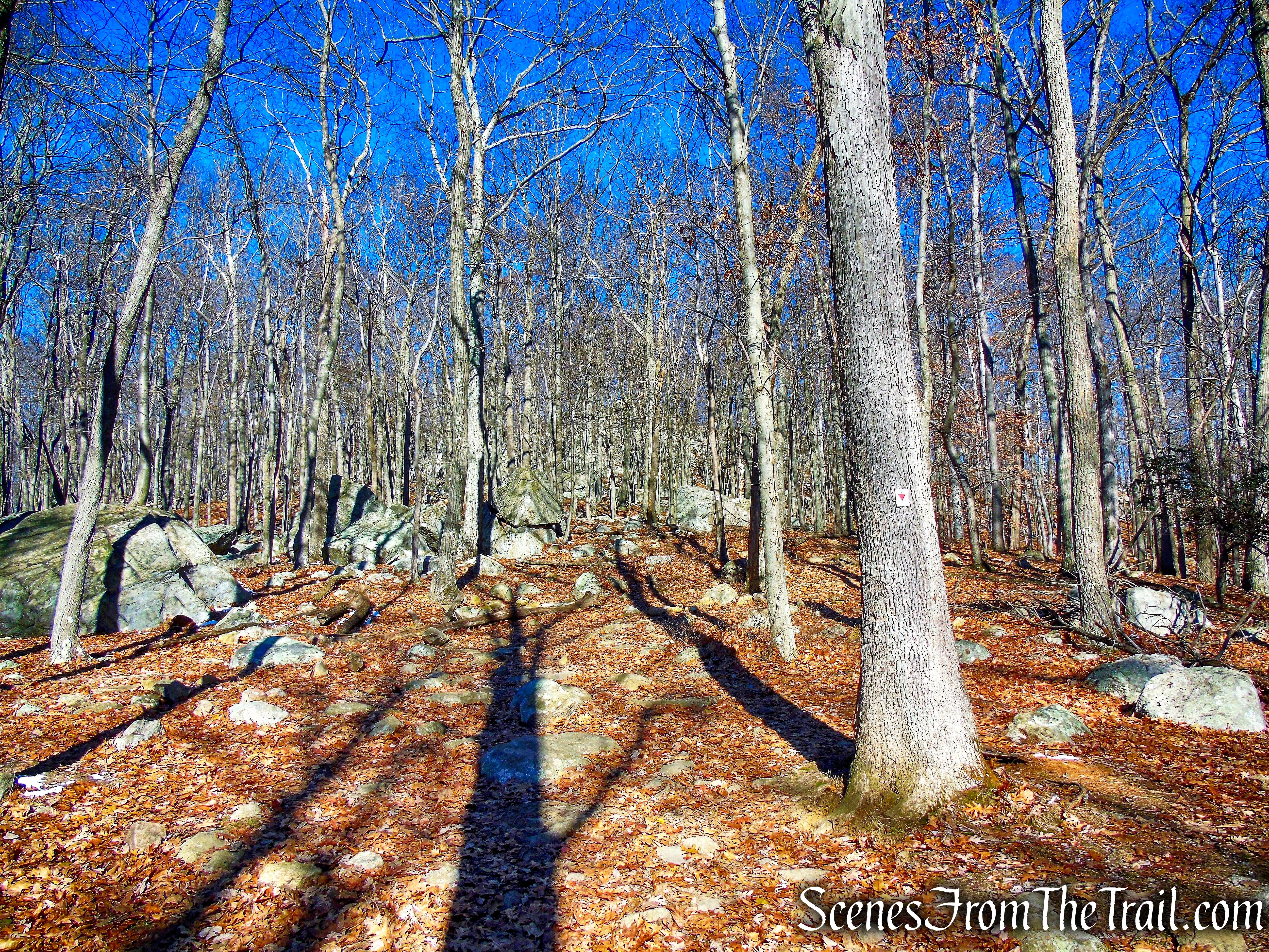
Arden-Surebridge (A-SB) Trail
This area has a lot of interesting looking boulders and rock formations that are easily visible with the leaves off the trees.
Arden-Surebridge (A-SB) Trail
In about 300 yards, after passing some large rock formations on the left, there are some stone steps on the trail. That was supposed to be our turn off point, but we continued on. I didn’t bother reading my own blog about a previous hike to the same spot. I figured that I would recognize the turn easily, but I was wrong.
Arden-Surebridge (A-SB) Trail
We continued on the ASB Trail a little further looking for a less steep section to leave the trail.
Arden-Surebridge (A-SB) Trail
We then turned left, leaving the ASB Trail and bushwacked west, towards the summit of Pine Swamp Mountain.
bushwack
We continued west through the quiet picturesque woods, until we ran into the old route of the ASB Trail and turned left. The footprints in the snow helped identify the old trail. I followed the footprints because I knew the general vicinity of the old trail. I am a little leery of following footprints in the snow because for all I know the hiker that left them may have been lost or just went to a different destination than I was headed.
bushwack
We followed the old route of the ASB Trail south, until we came to a rock outcrop with one of the finest views in Harriman. The Arden-Surebridge Trail was first blazed during the summer of 1921 by J. Ashton Allis. In December of 2014 the trail was rerouted from the summit, to the shoulder of Pine Swamp Mountain to alleviate erosion and ongoing impacts to sensitive habitats. The trail no longer passes this rock outcrop at the summit with a great view.
view from Pine Swamp Mountain
At the southwest facing viewpoint, Lake Skanatati (foreground) and Lake Kanawauke (background) can be seen from the summit of Pine Swamp Mountain.
view from Pine Swamp Mountain
After taking in the view, we bushwacked north, following the old route of the ASB Trail.
bushwack on old ASB Trail
The footprints in the snow, made it relatively easy to follow, although we lost the trail a couple of times. The current route of the ASB Trail is a couple hundred yards east, so I wasn’t worried.
bushwack on old ASB Trail
The old route eventually connects with the current route, and we continued heading north on the blazed trail.
Arden-Surebridge (A-SB) Trail
The trail then begins its descent of Pine Swamp Mountain.
Arden-Surebridge (A-SB) Trail
After about 0.5 mile after rejoining the ASB Trail, there is an unmarked fire road on the right. Almost immediately after passing that road, the mine workings of the Pine Swamp Mine complex come into view alongside the ASB Trail. Passing a small water filled shaft, there is a large open trench, fifty-five feet long and eleven feet wide, which contains several drilling holes.
Pine Swamp Mine complex
In another 200 feet there is a large rectangular cut on a low hilltop that is 118 feet long and twenty-nine feet wide, with vertical rock walls that are about twenty-two feet deep. This open cut is presently filled with water and should be approached with caution.
Pine Swamp Mine complex
In about 100 feet, the ASB Trail crosses a stream on rocks below an attractive cascade and turns right.
stream crossing – Arden-Surebridge (A-SB) Trail
Looking downstream.
cascading stream
Immediately after crossing the stream, there are three yellow blazes on a tree, indicating the start of the Dunning Trail which goes to the left. The blazes may not be immediately apparent, as they are more to the right and meant to be seen if one is coming down the ASB Trail in the opposite direction.
Dunning Trail
We turned left, leaving the ASB Trail and now following the yellow blazes.
Dunning Trail
After about 900 feet from the intersection with the A-SB Trail, there is an unmarked footpath to the right of the trail, by a broken tree.
unmarked footpath to Pine Swamp Mine
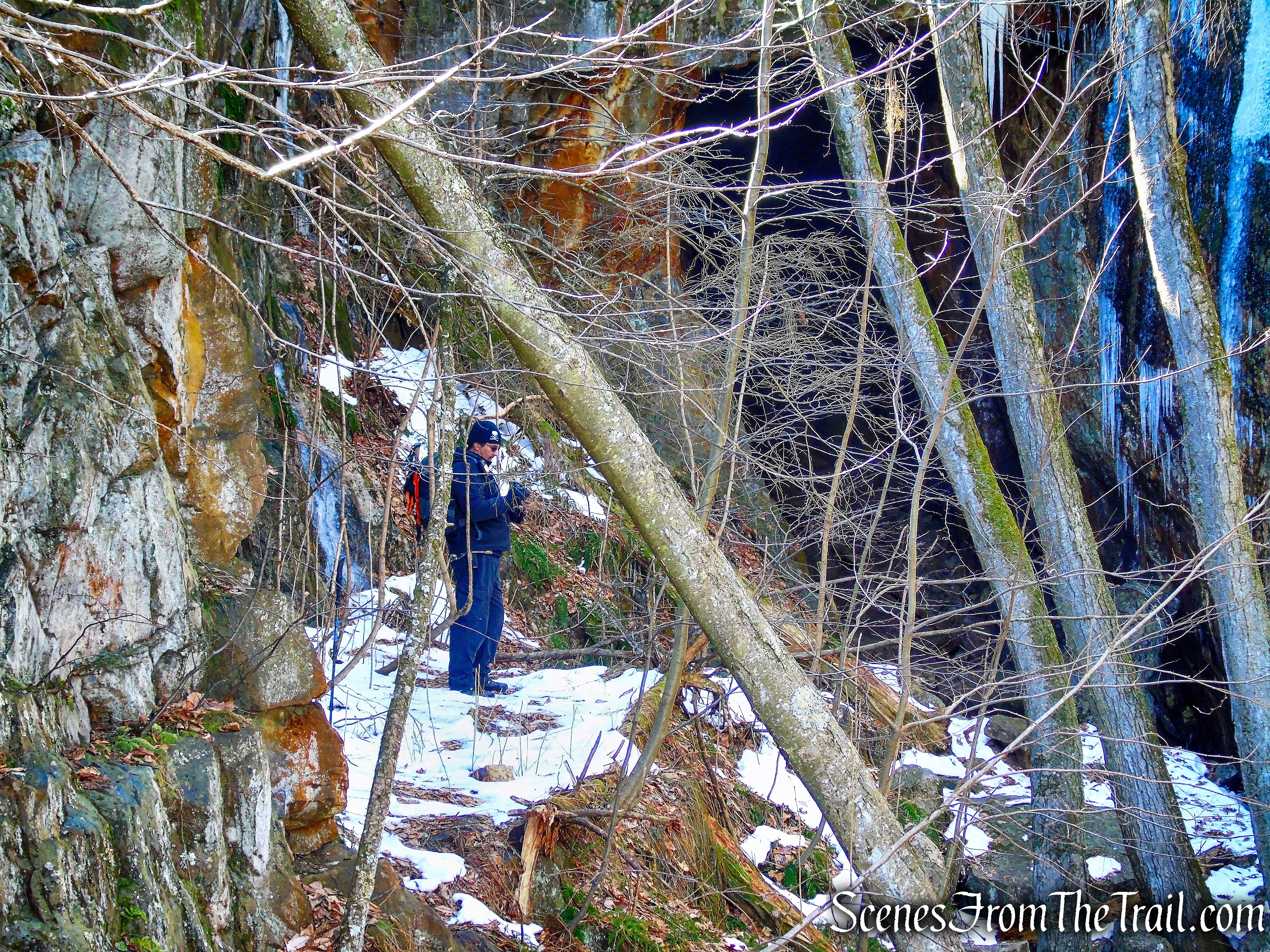
A large mine dump of rock or tailings rises steeply about fifty feet up the trail, and the mine is up the hillside nearby. The largest and most spectacular opening in this mine complex is located on the hillside above the Dunning Trail.
unmarked footpath to Pine Swamp Mine
Pine Swamp Mine is a large open cut about 100 feet long and forty feet wide, with vertical walls seventy-five feet high. Drill holes are visible on the rock walls, along with square and horizontal notches. The notches were probably seats for timber bracing. A rectangular water-filled shaft containing the remains of timbers is located along the bottom of the west wall of the open cut.
Pine Swamp Mine
At the southern end of the cut is an adit or opening to a horizontal passage that extends some 125 feet into the hillside. This passage slopes upward, and above its far end is an air shaft opening to the surface. On a sunny day, light pours through this rock-bound skylight, illuminating the long passage.
Pine Swamp Mine
The Pine Swamp Mine, part of the Greenwood group of mines, was opened around 1830 and worked intermittently until 1880.
Pine Swamp Mine
The mine was owned by Robert and Peter Parrott, and the ore was brought to Clove Furnace in Arden, New York for smelting.
Pine Swamp Mine
After checking out Pine Swamp Mine, we retraced our steps down the unmarked footpath, back to the Dunning Trail and turned right.
unmarked footpath to Pine Swamp Mine
The mine takes its name from the nearby wetland, Pine Swamp.
Pine Swamp
The blazes along this section of the trail are somewhat sparse, but it is easy to follow. The Dunning Trail was created by James Dunning, chairman of the AMC Trail Committee in 1934. This section was created in 1943 by Joseph Bartha who extended the Dunning Trail to reach the Arden-Surebridge Trail.
Dunning Trail
The Dunning Trail climbs gradually on an old woods road.
Dunning Trail
Dunning Trail
In just under 1/2 a mile, The Dunning Trail comes to a junction with the aqua-blazed Long Path and we turned left.
turn left onto the Long Path
The Long path descends gradually as it heads south through the woods.
Long Path
There are several stream crossings in this section, but all were manageable on this day.
stream crossing – Long Path
The Long Path then curves to the left and begins heading in an easterly direction.
Long Path
The Long Path passes by a massive rock ledge to the left.
large rock formation – Long Path
I spotted several caves high up along its face.
cave in rock formation – Long Path
cave in rock formation – Long Path
Long Path
The trail then crosses Pine Swamp Brook on large rocks,
stream crossing – Long Path
and soon starts to approach Lake Skannatati.
Long Path
Some large trees with some beaver damage along Lake Skannatati.
Long Path
The Long Path then comes to a small open area alongside Lake Skannatati, where we stopped briefly to enjoy the view.
Lake Skannatati
A short distance later, the Long Path emerges from the woods into the Lake Skanatati parking lot, where the hike began.
Lake Skannatati Parking Area
Lake Skannatati from the parking lot.
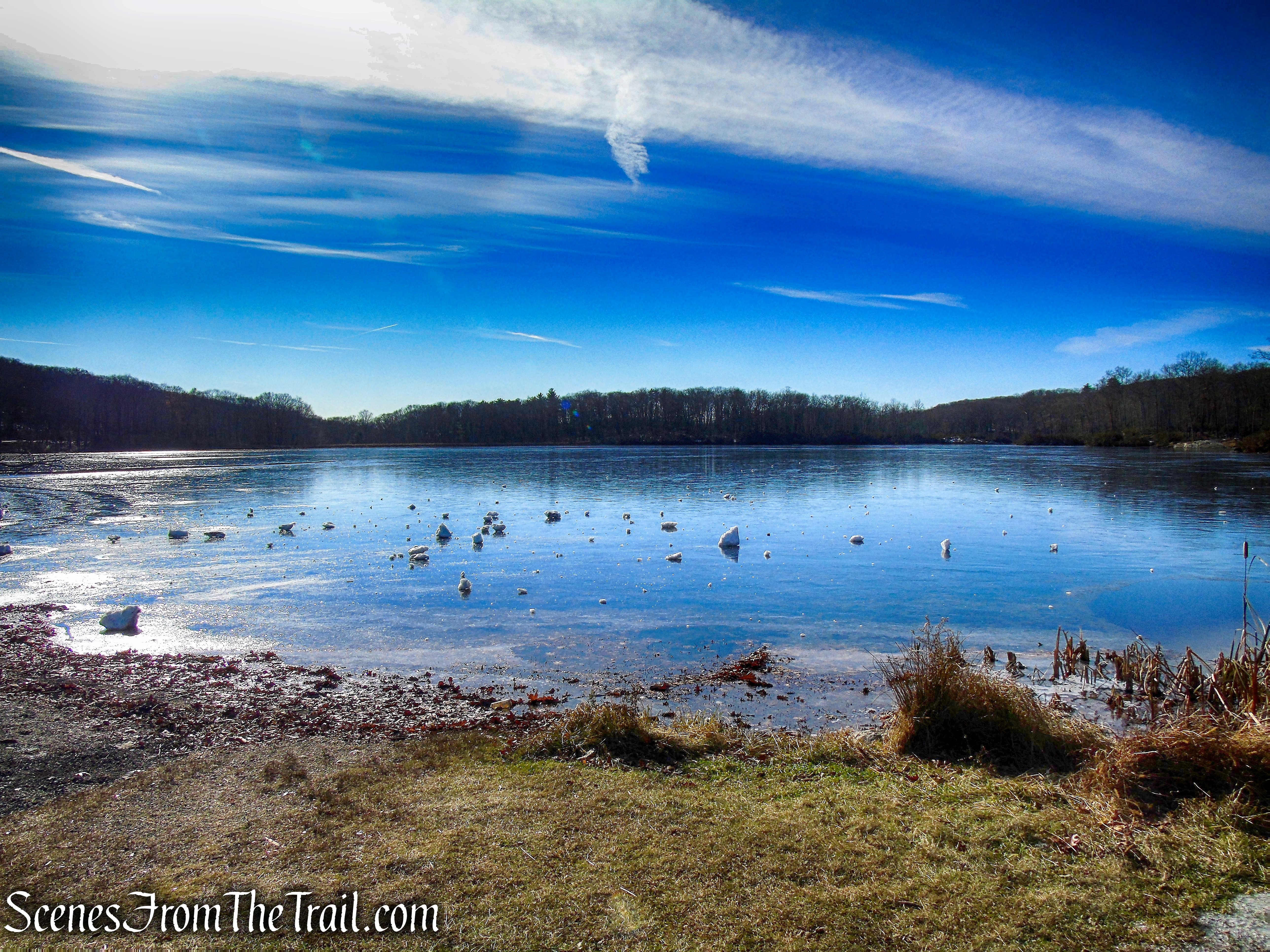
Lake Skannatati
Another great hike in Harriman State Park with lots to see. This is a short hike to do with minimal elevation, but numerous points of interests. I have hiked the area several times on longer loops and it never disappoints. The view on Pine Swamp Mountain is outstanding, with minimal effort to get there. The history of the mine operations throughout the park, make for an interesting day on the trails as well. We only passed a pair of hikers twice along the trails early on, but passed several groups on the Long Path as we neared the trailhead mid afternoon.
Pros: Well marked trails, Pine Swamp Mine, scenic view, Lake Skannatati, large parking lot, somewhat lesser traveled away from the trailhead.
Cons: Parking area fills up early during warmer months.
Take a hike!
Pine Swamp Short Loop – Harriman State Park
Sources:
- Myles, William J.. Harriman Trails: A Guide and History (Kindle Location 824). New York – New Jersey Trail Conference. Kindle Edition.

Sounds like you picked a good day to hit the trails. Black Friday sales never really happened here in Australia but this year it seems to be quite a big thing. We seem to get all your traditions eventually! Photos showing where beavers have chewed trees always shock me because I’ve never seen it in real life. I guess it’s quite a common sight though if you’re a regular hiker though.
LikeLiked by 1 person