Lancaster County Covered Bridge Tour – Lititz and it’s Countryside

June 14, 2016 – Lancaster County, Pennsylvania

I was off to Lancaster, Pennsylvania to visit it’s historic covered bridges. I have visited and photographed covered bridges in New York, Connecticut, Massachusetts and Pennsylvania in the past . Only problem is that they are spread out and that entails a lot of driving. I learned that in Lancaster County they are clustered together and that made it an easy decision to take a road trip to see them. Discover Lancaster has driving tours mapped out on their site which made it that much easier. They are divided into five different tours. I was able to complete three of them. I stuck to strictly the bridges because their tour also includes other attractions as well. I was only interested in covered bridges and since I was only spending two days in Lancaster I didn’t have enough time to see everything.

This tour included five bridges which were separated by about 10 miles. Most of the bridges are still being used today and are in pretty good shape. I will list the names of the bridges, some basic information along with some images below that I captured along the driving tour. I will not include the dates that they were built because some bridges were either washed away or extensively damaged during hurricanes. Some have been rebuilt several times. For more information on these bridges please visit Lancaster County Bridge Map.

Hunsecker’s Mill Covered Bridge  has a single span, wooden, double Burr arch trusses design. The bridge, which spans the Conestoga River is 180 feet long and 15 feet wide, making it the longest single span covered bridge in the county. The bridge is open to all traffic and in good condition. Click on the ensuing images to enlarge.

IMG_5978

Hunsecker’s Mill Covered Bridge

Pinetown Covered Bridge spans the Conestoga River and has a single span, wooden, double Burr arch trusses design with the addition of steel hanger rods. The deck is made from oak planks. It is painted red, the traditional color of Lancaster County covered bridges, on both the inside and outside. Both approaches to the bridge are painted in red with white trim, the length of the bridge is 133 feet and the width is 15 feet.

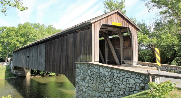
Zook’s Mill Covered Bridge spans Cocalico Creek and has a single span, wooden, double Burr arch trusses design with the addition of steel hanger rods. The deck is made from oak planks. It is painted red, the traditional color of Lancaster County covered bridges, on both the inside and outside. Both approaches to the bridge are painted red with white trim. The bridge is 74 feet long and 13 feet 3 inches wide.

Keller’s Mill Covered Bridge due to heavy road traffic on the aging, one-lane bridge, construction on a new steel and concrete bridge to bypass the covered bridge occurred in the summer of 2006. The bridge was disassembled and reassembled a few miles downstream to replace an existing one lane Mill Creek Road bridge.It has a single span, wooden, double Burr arch trusses design with the addition of steel hanger rods. The deck is made from oak planks. The bridge is the only all white bridge in the county, the only bridge to have survived the transition from whitewashing to the red color commonly used in barns throughout the county. The bridge is not painted on the inside. The length of the bridge is 74 feet and the width is 15 feet, it is open to all traffic and in very good condition.

Erb’s Covered Bridge spans Hammer Creek and has a single span, wooden, double Burr arch trusses design with the addition of steel hanger rods. The deck is made from oak planks. It is painted red, the traditional color of Lancaster County covered bridges, on both the inside and outside. Both approaches to the bridge are painted in the traditional white color.

That’s it for this leg of the tour. The next tour is the Northern Amish Countryside, which includes 5 more covered bridges.  Stay tuned……..

IMG_3979

Zook’s Mill Covered Bridge

Columcille Megalith Park

June ‎13, ‎2016 – Bangor, Pennsylvania

Difficulty: easy

Columcille Megalith Park is a privately owned park which is open to the public. It is located in Bangor, Pennsylvania which is less than a two hour drive from New York City. The park consists of large stones that are strategically placed throughout the property. It is a very tranquil place with natural beauty at every turn. I happened to learn of this park while searching online for places to visit in Pennsylvania. I knew I had to pay this place a visit. I wanted to get there early in order to be able to take photographs without people being in the shot.

I arrived at around 8am on a Monday morning and there was only one other car in the small parking lot beside the road. There were several signs informing us that we had indeed arrived.

From the start, I knew I had discovered a hidden gem. It was quiet and had a zen like  ambience. I recommend this place to anyone that would like to just escape from the grind of everyday life, if only for a few hours. I urge you to visit their website to learn more about the history of Columcille Megalith Park.

The park has trails throughout the property where one can get lost in nature. I wish I could have spent some more time there, it was that nice.

St. Oran Bell Tower was the first thing that caught my eye. I spent some time capturing images from almost every angle.

IMG_5729

St. Oran Bell Tower

Inside and out it was quite beautiful. Click on the ensuing images to enlarge.

The stone circle.

IMG_5745

The stone circle

IMG_5692

the stone circle

From the stone circle I headed towards the St. Columba Chapel.

IMG_5718

St. Columba Chapel

The Chapel is quite lovely and I believe it was the first structure built on the property in 1979.

From the chapel there was a stone lined path that led to Thor’s Gate.

IMG_5698

path to Thor’s Gate

Thor’s Gate in itself is quite impressive. Three large stones perfectly balanced together.

IMG_5700

Thor’s Gate

At every turn I could see the attention to detail. Every stone was carefully placed in it’s spot. Next I headed to the Labyrinth.

IMG_5701

Labyrinth

There are so many things to see here. I walked around taking photographs and I am sure I may have missed some of them, but below are some of the ones I did capture. Click on the ensuing images to enlarge.

I am glad that I had the opportunity to visit such a unique and spiritual place. Until next time, happy trails.

IMG_3602

Thor’s Gate


Dunderberg Spiral Railway – Bear Mountain State Park

June ‎11, ‎2016 – Jones Point, NY

Difficulty: moderate – strenuous

Length: approximately 4 miles

Route type: circuit

Dunderberg Spiral Railway was an incline railroad that was supposed to take visitors up to the top of the mountain. Construction began in 1890 and ceased about a year later. It has been reported that about a million dollars was spent on the project before funds dried up. Needless to say, it was never completed. I decided to go have a look.

I followed the same hike as described here by the The New York-New Jersey Trail Conference. They are a great resource for information on hiking. On this hike I used the Harriman-Bear Mountain Trails Map set. Since this hike incorporates unmarked roads and trails having a map of the area is essential.

From the parking area I walked south along the road until I saw the trailhead on the right.

DSC01488

Timp-Torne (blue) and Ramapo-Dunderberg (red-dot-on-white) trails

From there I proceeded into the woods following the well blazed trail.

Almost immediately I came upon the first tunnel. It was just off the trail to the left.

I explored the tunnel for a bit and took some photographs. It seemed to be a busy spot as I saw a few groups of hikers coming along as I was about to leave. I continued up the trail which now steepened.

After a relatively short, but steep climb I reached a clearing where there were partially obstructed views of Indian Point. From here the trail split. The Timp-Torne (blue) went left and that is the route I took. It climbed steadily and for some reason it was wearing me down. I had to take a few minutes to catch my breath and gather myself. It was not that hot, but I seemed to be dehydrated. After drinking some fluids, I continued on. There was no way I was going to quit. I continued following the blue blazed Timp-Torne trail.

Soon I reached a graded section of the railway which was much more pleasant to walk.

DSC01528

graded section of the railway

After a short walk along the graded section I could see the second tunnel come into view. It looked more like a cave than a tunnel. It is about 75 feet deep and quite dark. A headlamp or a flashlight comes in handy here. I explored inside and took numerous photographs. It was quite impressive to say the least.

It was time to move on, so I continued following the graded section of the railway which was the only easy hiking I would do on this day.

It was a scenic walk throughout this hike, with interesting rock cuts and views along the way.

DSC01554

rock cut

After crossing a mostly dried up stream I turned right onto the Jones trail. It is unblazed and from what I read many hikers miss this turn and end up getting lost. I paid careful attention and made the proper turn. After a rocky walk uphill, the trail was filled with Mountain Laurel.

DSC01566

Mountain Laurel

After reaching an intersection with the Ramapo-Dunderberg (red-dot-on-white) trail, I turned right and continued up the mountain and took a well deserved break on a rock outcrop with limited views.

DSC01579

rock outcrop with limited views

My break was cut short as it began to rain and I decided to get moving. The rain helped to cool me off, but it did keep me from capturing more images of the hike.

After a short while I reached the best viewpoint of this hike. I was still feeling a little weak and tired so I mostly rested and missed out on some good shots.

DSC01582

best view

The rest of the hike was a lot of ups and downs filled with loose rocks. I had to keep my eyes to the ground to make sure I stepped in the right place or risk twisting an ankle. Some more views along the way were to be had.

After descending steeply I reached a stone abutment which had something to do with the railway.

DSC01600

stone abutment

Continuing down the extremely rocky trail, I turned around and took a look back. It was pretty steep, but I hadn’t really noticed because my eyes were glued to the ground in front of me.

DSC01605

rocky trail

Despite not feeling well throughout most of this hike, I enjoyed it. Although it was rough going for most of the way, it was a very scenic hike. Now it was time to go. I had to rest up because in two days I was taking a road trip to Pennsylvania.

Stay tuned……..

014

happy trails

Veterans Flag Hike – Darcy’s Ridge

May 30, 2016 – Beacon, NY

Difficulty: strenuous

Length: approximately 3.5 miles

Route type: out and back

Many hikers across the Fishkill Ridge mountain range that includes Mt. Beacon and nearby peaks, are treated to a rare sight, an American Flag flying on a makeshift pole high above the trees.

DSC01378

Veterans Flag

Many have speculated or wondered what the origin of this monument might be.

Let me solve the mystery for you.

Somewhere around Memorial Day of 1988, the City of Beacon fathers were considering canceling the Memorial Day parade due to “insurance” concerns. This was unacceptable to members of the Darcy family who had served in the military and felt strongly about the continued recognition of American Veterans. Bob, Dean, Pete and Pete’s son Matt decided to camp out on the mountain and erect a Flag in memory of those who had given their all.

What was originally intended to be a solitary tribute has become a permanent gesture. Every year and sometimes twice a year depending on condition, this flag is replaced by John Darcy or a friend of the Darcy family. Many in the family and extended family, have taken on the responsibility of helping John to insure that a flag flies on this ridge like it has since 1988.

The tribute holds another special meaning to the Darcy family. At Bob’s passing, his request to have his cremated remains placed near the flag was honored. Dean, Pete, Matt, John and Bob’s wife Judy, along with other family members and friends again climbed the mountain in August of 1994. Bob continues to enjoy the serenity of this awesome location atop Fishkill Ridge and the Darcy family continues it’s tradition.

Dean, Pete and Matt all reside in Georgia with their families but a hike ‘up-the-mountain’ is always part of their visits back to Beacon. If you happen upon the flag during a hike, stop, enjoy the view and say a prayer for those who can’t. If you find the flag a little worn or tattered, contact any Darcy and it will be replaced. Mystery solved.

Pete, Dean and Matt Darcy

This is a photograph of Bob Darcy the day they placed the flag up on Darcy’s Ridge. May 31, 1988. Photo is courtesy of Dean Darcy.

bobflag1988

Robert Darcy – May 31, 1988

I had heard of a flag somewhere on Fishkill Ridge, but didn’t know the story behind it. I wanted to visit and photograph it. Upon researching it and then learning of the history behind this flag, I was going to hike up there to honor and pay my respects to all those that have paid the ultimate price for the freedoms that we all enjoy. I have to say that this was easier said than done. I could not find much info on where exactly the flag  was. I pieced together the little info I had and gave it a shot.  The Fishkill Ridge mountain range is very rugged terrain and I had never hiked that region before. On two occasions in 2015 I hiked up there and wandered all around to no avail. It was frustrating to have not found that flag, but I was going to try again. A few weeks ago I saw a Meetup titled: Veterans Flag Hike – Memorial Day. I knew that was the flag. I was the first one to sign up and I was raring to go. The Meetup was arranged through the Mid-Hudson Adirondack Mountain Club.

This hike started at Pocket Road in Beacon, NY. The Fishkill Ridge Trail begins there.

After some info from the hike leader Christopher, we were off. I was the first one up the trail and I stayed in front for the entire hike. The white blazed Fishkill Ridge Trail immediately headed uphill along a gravel road.

We walked along a brook which had some pretty cascades.

After a steep climb of about .8 miles and an elevation gain of about 700 feet, we reached the access road. We were now ready to bear right just off the Fishkill Ridge Trail and proceed on an unmarked woods road, which seemed more like a gully than a road.

From there we went to the Blue Connector Trail then steadily up the  yellow Wilkinson Memorial Trail.

A short while later I made the final push up another unmarked trail.

DSC01467

unmarked trail

I was finally at the flag! After reaching an elevation of approximately 1500 feet I was out of breath and had to take a minute before I could break out my camera and take a few shots.

DSC01387

Veterans Flag

They held a small ceremony at the ridge with a couple of musicians that played the National Anthem, Taps and also the anthems for each branch of the service. The fog rolled by as the musicians played.

DSC01398

musicians

Members of the Darcy family, John and Richard.

Those that hiked “Darcy’s Ridge” to honor the fallen.

DSC01391

hikers

Upon speaking for quite some time to John Darcy, I asked him what this area was called. He likes to refer to it as Darcy’s Ridge. It is not the official name, although it should be. I will always refer to it as Darcy’s Ridge and maybe the powers that be could make it official.

After the ceremony was over I wanted to stay back and take in this place in all it’s glory. So as everyone was now gone I just soaked up the sun and some history as I sat there admiring the view. The sky cleared up and I could see way up the Hudson.

DSC01448

Hudson River

After spending some time enjoying the view, it was time to depart. Since it was an out and back hike, I retraced my steps back to Pocket Road. Along the way I saw a couple of snakes and a small Chihuahua that hung out and led me down the Fishkill Ridge Trail. Click on the ensuing images to enlarge.

This was one of the more enjoyable hikes that I have done. Third time was the charm. I thank the Darcy family for maintaining that flag all these years and for their patriotism. After all, we are the “Land of the Free Because of the Brave.”

DSC01435

Veterans Flag atop Darcy’s Ridge

Until next time, happy trails.

043

me

Untermyer Park and Gardens

August 25, 2014, May 29, 2016,  August 13, 2016,  August 21, 2016 – Yonkers, NY

Difficulty: easy

Untermyer Park and Gardens previously part of an estate known as Greystone, is a historic park of 43 acres situated in Yonkers, Westchester County, New York. Samuel J. Untermyer, a prominent New York lawyer, purchased Greystone at auction from the estate of Samuel J. Tilden in 1899. The estate originally sat on 150 acres of land. After his death on March 16, 1940, the property was willed to the City of Yonkers. It opened to the public as a park in 1946, but with only 43-acres of the original land. The rest was used for St. John’s Riverside Hospital & a few other surrounding properties. Two years later in 1948 the Greystone mansion was demolished.

By the 1960’s the park fell into disrepair. In the 70’s the park was a frequent hangout of “Son of Sam” David Berkowitz and his satanic cult. I have been going to Untermyer Park since the 70’s. Back then, we visited at night to drink beer and hang out. I had never heard of “Son of Sam” when I started going there, but did see a lot of strange things at night. I saw dead animals that looked as they were sacrificed in a ritual and also witnessed hooded figures chanting in Latin I believe, as they walked through the woods. They even had some underground rooms that had an altar and satanic writings all over the walls. They have since been filled in.

In recent years the City of Yonkers has begun a significant restoration and has transformed this park from a dump to it’s former glory. The park has it all, architecture, landscaped gardens, views, history and ruins. This is more of a walk in the park than a hike although it does have a few trails. I will just post some images of points of interest in the park with a brief description.

UNTERMYER PARK MAP

park map

The images that appear in this post were shot during four different visits to the park.

Immediately after leaving the parking area you will come upon a memorial. This is a memorial dedicated to the fallen firefighters & police officers of the City of Yonkers. It is not solely for the ones lost on September 11, 2001.

fallen firefighters & police officers memorial

fallen firefighters & police officers memorial

As you continue past the memorial you will see the walled garden.

The Park was added to the National Register of Historic Places in 1974.

Historic landmark plaque

Historic landmark plaque

The Walled Garden was based on Indo-Persian paradise gardens and included many of their traditional elements: the use of waterways to divide the garden into four quadrants, massive gates, and surrounding walls anchored at their corners with octagonal towers.

walled garden entrance

walled garden entrance

Temple of the Sky, a roofless circle of Corinthian columns.

Temple of the Sky

Temple of the Sky

The mosaic tiled floor of the Temple of the Sky.

Temple of the Sky

Temple of the Sky

At one time the pool was tiled completely in mosaic.

Temple of the Sky pool

Temple of the Sky pool

Facing north towards the amphitheater.

facing north

facing north

The amphitheater.

The amphitheater

The amphitheater

Facing south.

Facing south

Facing south

Facing south

Facing south

Thousand steps and/or The Vista.

Thousand steps

Thousand steps

The Vista

The Vista

The view from The Vista is the Palisades and the Hudson River.

the Palisades and the Hudson River

the Palisades and the Hudson River

Garden ruins is also the area of the “Devil’s Cave” a place where Son of Sam and his cult once held court. The caves have been filled in.

Garden ruins

Garden ruins

Gate house ruins, I was watching Law and Order SVU one night and saw this in one of the episodes. Click on the ensuing images to enlarge.

They recently replaced the rear gate and the fence which had been missing for years.

rear gate

rear gate

A couple more shots that I took recently.

Gate house ruins

Gate house ruins

Gate house ruins

Gate house ruins

Gate house ruins

Gate house ruins

The eagle’s nest, this is the area that at one time was used for animal sacrifices. They now call it “The Temple of Love.” I prefer eagle’s nest.

eagle’s nest

eagle’s nest

eagle’s nest

eagle’s nest

Looking skyward from the eagle’s nest.

eagle's nest

eagle’s nest

Underneath the eagle’s nest.

Underneath the eagle's nest

Underneath the eagle’s nest

Underneath the eagle's nest

Underneath the eagle’s nest

On my last visit here on August 21, 2016 I was able to capture some images of the newly renovated waterfall, that hasn’t flowed in decades.

waterfall

waterfall

waterfall

waterfall

I have to commend the City of Yonkers for pouring money into this park. It is a perfect mix of the past and present. I urge everyone to pay this place a visit. You won’t be disappointed. There is no charge for visiting this park.

Until next time, keep on trekking……

keep on trekking

keep on trekking

Bradley Mine – Harriman State Park

May 28, 2016 – Harriman State Park, Orange County, NY

Difficulty: moderate

Length: approximately 3 miles

Route type: out and back

I like to check out interesting places when I hike. If a hike doesn’t have a payoff then it’s just a walk in the woods. So I decided that I will begin to explore some of the mines that occupy Harriman State Park. The first mine that I wanted to visit was the Bradley Mine which is supposed to be the largest of all the mines in Harriman. There is not a lot of information available online about this particular mine. Here is some info that I dug up, but I am not sure how accurate it is. Bradley Mine is the largest of the mines in Harriman and was mined for iron ore by the Parrott brothers during the Civil War. These two brothers owned most, if not all of the mines in Harriman. The iron mined here was sent to nearby Greenwood Furnace, where it was made into munitions during the Civil War.

Alright, with a little history out of the way, mines are kind of cool because they are like caves and who doesn’t like caves? This hike started from the Tiorati Lake Recreation Area which is located right by Tiorati Circle. From Memorial Day to Labor Day there is a parking fee of $10.00 per car, unless you have an Empire Passport, which costs $65.00 $80.00 and provides unlimited day use vehicle entry to most facilities operated by the New York State Office of Parks, Recreation and Historic Preservation and the New York State Department of Environmental Conservation. It is well worth having one of these.

Upon entering the parking area, we parked on the right side facing the woods because we would start off by following the blue blazes of the Lake Tiorati Trail. The trailhead is just to the right of this sign.

DSC01238

Lake Tiorati parking area

We searched for the faded blue blazes as we walked up the hill. The trail initially leads towards the road and then bears left and into the woods.

The trail then climbs to the crest of Fingerboard Mountain, paralleling Arden Valley Road. After about 1/3 of a mile we came upon an old water tank on the left.

Directly in front where the Lake Tiorati Trail ended was a newer water tank.

DSC01183

newer water tank

We turned right here onto the white blazed Appalachian Trail (AT) and the red dot on white blazed Ramapo-Dunderberg (R-D) Trail.

We walked briefly on the AT/R-D trail until we came to a chain across the trail.

DSC01189

Appalachian Trail/Ramapo-Dunderberg (R-D) Trail

The trail crosses Arden Valley Road here, but we turned left for a road walk at this point.

After a short walk downhill, the Long Path (teal blazes) crosses the road. It is not too long after this point where we came to an unblazed trail on the right. The trail is directly to the left of this sign and boulder.

The trail was very steep with a lot of loose rocks and soil. We took our time and paid careful attention to not kick any loose stones back onto those behind us.

DSC01192

mine access trail

Once at the top of this short, but steep climb I looked to my right and I could see a narrow path between two vertical rock faces, which led to the mine.

Immediately I could feel a cool breeze emanating from the narrow crevice. After working up a sweat in 87 degree heat, that felt nice. The closer we got to the mine the cooler it got. It felt like we had walked into an air conditioned room. I made plenty of noise as we approached the mine just in case there were any critters lurking around in there, I did not want to surprise and/or corner them.

The closer we got, the colder the air got. All of a sudden I could see the opening of the mine. It was dark and there was a glare from the morning sun which made it appear foggy around the entrance.

I entered inside, but even with my headlamp and flashlight visibility was poor. There was a hole in the ceiling of the mine which let some light in which caused a glare inside and gave an eerie feel to it.

These are some more images taken from inside Bradley Mine.

To get an idea of how cavernous this mine is I added an image of me as I was venturing inside.

IMG_3344

Bradley Mine

After spending some time inside and hearing some strange noises, It was time to leave. These are some images from the entrance of Bradley Mine as we made our way back.

After retracing our steps and making it back to the Lake Tiorati parking area, we broke out the food and drink. We relaxed in the shade for a while until I decided I wanted to go back and take some more photographs. At this time it was afternoon and the sun had shifted. I figured I could get some better shots. As it turned out I was on my own for the return visit. Hiking alone I was able to move a little faster and was back within the hour. A few more images below.

That’s all for today. Until next time, happy trails.

042

me in front of Bradley Mine

Road to Ruin – Harriman State Park

May 22, 2016 – Harriman State Park, Stony Point, NY

Difficulty: moderate

Length: approximately 4.5 miles

Route type: out and back

To keep in the spirit of recent hikes, We were off to see more ruins before they get completely covered in green. Harriman State Park is the second largest state park in New York. Located in Rockland and Orange counties, 30 miles north of New York City, it is a haven for hikers with over 200 miles of hiking trails. The park is also known for its 31 lakes, multiple streams, public camping area, and great vistas. The park’s hiking trails are currently maintained by volunteers from the New York – New Jersey Trail Conference.

On this hike we would be following the yellow blazes of the Suffern-Bear Mountain Trail for a good portion of the way. So armed  with a Harriman-Bear Mountain Trails Map  we started off our hike by parking in a small lot on CR 106 right alongside Minisceongo Creek, which has some very nice cascades along with some scenic spots to relax.

From the parking area we proceeded towards the creek and turned right just before the small bridge which crosses it. There is a white arrow painted on the pavement which was helpful.

We started off with a mostly level woods walk with the soothing sounds of Minisceongo Creek to our left.

DSC01046

Suffern-Bear Mountain Trail

After a short walk, the trail led us away from the creek and started to rise. We were in for our first ascent of the day.

As the trail started to level off, a huge glacial erratic known as Irish Potato which sat alongside the trail came into view.

To get an idea about how large it is I added an image of me standing in front of it.

IMG_3172

Irish Potato

We continued on the S-BM Trail for awhile until we came upon an unmarked trail that veered right as the S-BM Trail veered left. We proceeded along the unmarked trail which became hard to follow, but I could see Upper Pound Swamp (which is really a lake) through the trees, so we just bushwacked through the woods towards it.

DSC01061

Upper Pound Swamp

Once along the water, the trail became visible again and now we were looking for a woods road that went to the left. That would bring us to the first ruins of the day. As we ascended up the unmarked woods road I saw what appeared to be a stone wall partially covered by trees on the left. There it was, the Rose O. Redard estate. This former estate is said to be that of the heiress of Red Rose Tea fame, but after doing a little research it does not appear to be so. Click on the ensuing images to enlarge.

After exploring these ruins and taking a well deserved break, it was time to move on. We had to retrace our steps back to CR 106 where our vehicle was parked to continue on to part 2 of this hike. The section of the Suffern-Bear Mountain Trail where the other ruins were located continued on the other side of the road. Up to this point we did not see another soul along our route until we saw a father and son fishing at Upper Pound Swamp on the way back. The return was made more difficult by having to hike back up Irish Mountain. It was a picturesque hike nonetheless with nothing but the sounds of birds and interesting rock formations dotting the landscape.

We took a break back at the parking area and decided what our next move was going to be. Originally we were going to hike up past the Jackie Jones Fire Tower to the Big Hill Shelter which would have added another 4.5 miles to our hike. Upon further review we decided to just visit the ORAK ruins which only added another mile or so. We started at the gated paved road, once again following the yellow blazes of the Suffern-Bear Mountain Trail.

DSC01118

Suffern-Bear Mountain Trail

We followed the S-BM trail uphill on the paved road for about a quarter mile until it veered left onto a woods road and a few minutes later we were there. More ruins! Known as ORAK, the mansion was built in 1923 by George Briggs Buchanan, a vice president of the Corn Products Refining Company, which manufactured Karo syrup (Orak is Karo spelled backwards). After Buchanan died in 1939, his heirs sold the mansion to the park, and it was demolished in 1973. Click on the ensuing images to enlarge.

After passing the gate house we saw some more of the former estate.

After exploring and photographing these ruins we decided it was time to get our grill on. We retraced our steps back to the vehicle and headed off to enjoy the rest of the afternoon with some food and drink. On the way back we encountered this Black Rat Snake that was slithering amongst the stones of the once mighty estate.

Until next time, happy trails.

023 (1)

me

Storm King Mountain Loop via Stowell Trailhead

May 15, 2016 – Cornwall-on-Hudson, NY

Difficulty: strenuous

Length: approximately 6.5 miles

Route type: lollipop loop

Storm King Mountain rises 1340 feet high above the Hudson River with fantastic views north, east and south. It offers over 11 miles of challenging trails, which are steep, narrow and rocky. To put it bluntly there is nothing easy about Storm King Mountain, but the payoff is worth it. I have wanted to hike Storm King ever since I climbed Breakneck Ridge which is directly across the river. On this day I felt as though I climbed it twice.

I had read about some ruins that existed up there from an upcoming hiking Meetup. Supposedly there were extensive remains of a mansion that were not widely known to most that hike in that area. With the exception of the Spy House ruins, which consists of three columns that are located not too far from one of the trailheads on 9w, I couldn’t find the existence of any online. I consulted my West Hudson Trails Map and I saw that on one unmarked trail there were 2 sets of ruins. I figured that one of these were the ruins mentioned in the Meetup post. Not one for crowds, I decided to check out what these mansion ruins were all about.

This hike started at the Esty & Hellie Stowell Trailhead located on Route 218 right by Camp Olmsted. The parking lot has room for about 20 cars and from my understanding is one of the least used trailheads by hikers. Maybe the fact that it is located at the base of Storm King and other trailheads are located further up the mountain. I wanted to do it right, so we started from here. After applying some bug spray and gearing up, we were on our way.

Our hike began on the teal blazed Highlands Trail, which started out crossing an open field with Storm King looming large just across the field. It was a pleasant level walk, but that didn’t last for long. In no time we entered the forest and our hike up the mountain began.

Almost immediately the trail steepened. At first we walked along a cascade that descended from high atop the mountain.

Then we crossed the brook and left the cascade in our tracks. We advanced up the Highlands Trail which continued to rise. We came to a junction where the yellow blazed Stillman Trail came in from the right and joined the Highlands Trail, so we turned left and were greeted with our first view of the day.

DSC00892

first scenic view

After taking a well deserved breather we were off again, now following the teal and yellow blazes of the Stillman/Highlands Trail.

DSC00902

Stillman/Highlands Trail

We were searching for the blue and red blazed Bluebird Trail which is a right turn off the teal and yellow blazed Stillman/Highlands Trail. We came upon another junction where there was an unmarked woods road and the yellow Stillman trail on the right as the Stillman/Highlands Trail went left. I consulted my map and determined that this was the right we had to make. I was wrong, the Bluebird Trail is actually off the Stillman/Highlands Trail. I didn’t figure that out until we hiked about 3/4 of a mile in the wrong direction adding another 1.5 miles to this hike. It wasn’t all in vain though as we saw an interesting curved stone wall to photograph.

Not too far from the stone wall was a strange looking tree that seemed to have faces trying to escape from within.

After heading back in the right direction we continued up the Stillman/Highlands Trail which was quite steep in places.

DSC00923

Stillman/Highlands Trail

After a short while of climbing up the Stillman/Highlands Trail we saw the Bluebird Trail and also saw some ruins that were just off in the woods. I’m not sure what the first structure was, but I am assuming that it was a well of some sort as it was filled with water and had a pipe protruding from it at the base. There was also a foundation of a building not too far away.

DSC01039

possibly a well

We continued up the Bluebird Trail which was also steep and rocky. I knew that the unmarked trail where the ruins was supposed to be was off to the right. For most of the trail there was a steep drop off on the right so when we came to a section where there was a hill to our right, I bushwacked to the top of the hill to take a look and there it was. I walked over to the unmarked trail which was barely discernible and in a moment we were at the mansion ruins. They were quite extensive and by the looks of it, must have been quite an estate. I have done numerous searches online and could not find any information whatsoever on this set of ruins. Click on the ensuing images to enlarge.

We sat on the steps pictured above for a rest before we continued on. All of a sudden it started to hail. Ice pellets bouncing off my head in May? It was time to move. The Bluebird Trail continued to rise and the only hikers we saw were coming down. I asked one of them if it is mainly hiked downhill and he told me yes. Due to the steepness of the trail I now see why.

We stopped along the Bluebird Trail for a break and sat across from this interesting rock formation that had a cave like appearance.

DSC00971

cave like rock formation

For a trail that is supposed to be only .6 miles long, the Bluebird Trail felt much longer. Alas, we finally made it to the blue blazed Howell Trail. It was a welcome sight and from appearances it seemed like we were in for a pleasant walk through the woods. That would be short lived however.

DSC00972

Howell Trail

The Howell Trail was scenic and had some obstructed views of the Hudson Valley.

After the partially obstructed view, the Howell Trail became a cliff walk and started to descend somewhat steeply. Now we were looking for the white blazed By-Pass Trail, that would require us to regain the elevation we lost descending the Howell Trail. The By-Pass Trail was only .4 miles long, but rugged and steep. I didn’t photograph on the way up as I was focused on the task at hand. I did take one at a scenic view when we stopped to rest.

DSC00982

By-Pass Trail

When we finally made it to the end of the By-Pass Trail, we met up with the Stillman/Highlands Trail once again. Now we were in for some real views.

After taking in some views we went to the highest point, which offered up a fantastic view north up the Hudson.

DSC01004

view north

We were now at 1340 feet and the sky was overcast with winds between 30-40 mph. Not idea conditions for taking photographs, but we made due. Below are some images taken from this vantage point.

It was a shame that after such a strenuous trek to get to this point we couldn’t enjoy it more. I was dressed for a May hike and the wind was cutting right through my windbreaker. So after a snack and a drink we began our descent. I didn’t bother to take any photographs the rest of the way as I was all pictured out by this point. The way down was no cake walk either. We hiked down the eastern side of the mountain on the Stillman/Highlands Trail. It was steep, rocky, narrow and in some spots wet and muddy. All these factors made the descent worthy of our full attention. We stopped several times along the way and then back to the vehicle. It was now time for some grilling.

Until next time, happy trails.

IMG_3138

me

Dover Stone Church

May 14, 2016 – Dover Plains, NY

Difficulty: easy

Length: approximately 1.2 miles

Route type: out and back

A more recent hike that includes all of the trails: Dover Stone Church – Full Loop

Dover Stone Church is an ancient cavern on the Stone Church Brook in Dover Plains, which is located in Dutchess County, NY. According to local legend, the site was a refuge for Pequot Sachem Sassacus and his warriors as they fled from the English Army in the 1600’s. Inside the cavern is a waterfall cascading into a pool of water that flows through and then out of the cavern entrance. It is one of the most picturesque spots I have ever visited. I have gone there quite a few times in the different seasons and it never disappoints. In 2015 three new trails were added. The hike to and from the waterfall is just over a mile round trip. This is the hike I did today.

The trailhead is located on Route 22 between Dover Plains High School and the traffic light on the opposite side of the road. there is a blue and yellow historic marker right at the edge of a private driveway.

DSC00831

Historic marker

There is no parking in that driveway. I always park in the large lot by the traffic light and have never had any issues. If you park in the driveway where the trailhead is located your car will be towed. We proceeded up the driveway and immediately see another sign (there are several signs along the way) at the back of the driveway.

From that sign we walked down the concrete steps to a path lined with trees.

Once at the bottom of the stairs we proceeded through the tree lined path. From start to finish it is quite scenic.

DSC00838

tree lined path

At the end of this path was another set of concrete steps, but much smaller. These steps led us into the forest temporarily.

After a short walk between two fence posts a large kiosk was visible. The kiosk had a small sign nailed to it that directed us left, but even if we didn’t see that small sign it was obvious which way to go.

Once past the green sign above we paralleled the brook. and came upon a small wooden footbridge with stone foundations.

DSC00850

footbridge

Once over the footbridge we veered right and came upon the sign which pointed out the directions of all the trails. We wanted to see the Stone Church, so we turned right.

DSC00854

trail sign

The rest of the way to the cave, the trail is made up of stones which line the left bank of the brook. The stones are always wet and can be slippery, so we proceeded with caution. Click on images to enlarge.

In a moment we were greeted with a lovely cascade that was a mere morsel compared to the main course.

DSC00864

cascade

Almost immediately after the cascade, there it was. The Stone Church in all it’s glory. One of my favorite places to visit.

DSC00870

Stone Church

This is one of those places that photographs do not do it justice. You have to see it in person to fully appreciate it’s beauty. Click on the ensuing images to enlarge.

I walked to the cave and carefully stepped on the wet and wobbly stones in order to step inside. Now I was in church. Happy Trails, until next time.

IMG_3005

me

Leon Levy Preserve – Black Mansion Ruins

May 8, 2016 – Lewisboro, NY

Difficulty: easy

Length: approximately 4 miles

Route type: circuit

For an updated version of this hike, click HERE.

Leon Levy Preserve is a 386-acre preserve which contains an extensive system of hiking trails, including an old carriage trail, and is open to town residents for hiking, snowshoeing, biking, and horseback riding along with ruins of the Black mansion (1899-1979) and other outbuildings.

I am trying to get as many hikes that include ruins done before they get overgrown with weeds and vines. Once the green fills in they will be more difficult to see, navigate to and most importantly photograph. So armed with a trail map which I got off the preserve’s website I was ready to go. The white sign at the entrance is not very visible so slow down so you don’t miss the parking lot, which has ample room for enough cars.

The  beginning of the blue trail is just to the left of the kiosk, which has a lot of useful information, including a warning about hikers being attacked by bees. Luckily we didn’t encounter any on this day.

We started on the blue trail which is the main trail on the preserve and immediately had the option of going left onto the white trail or turning right onto the blue trail. We wanted to see ruins so we turned right. The blue trail had a gentle ascent and was easy to walk.

DSC00759

blue trail

Almost immediately we were greeted with the first ruins of the day. It looked like it had been a small stone cottage at some point. All that remained was the foundation and the fireplace and chimney.

After snapping a few shots we continued up the blue trail which turned left and then reached a junction with the yellow trail aka Black Mansion Trail. The blue trail veered to the left and the yellow trail veered right. We went to the right.

DSC00768

yellow trail junction

The ruins of the mansion were visible through the trees as we headed towards them. There was an unmarked trail that led to the left and I walked  it to get a closer look.

We took some shots from this vantage point then proceeded back to the yellow trail.

We walked to the clearing on the yellow trail and wandered around trying to fight the sun as we tried to get the best angle to capture some images. Click on the ensuing images to enlarge.

DSC00820

Black Mansion

Once we were ready, we proceeded on the yellow trail and immediately turned left onto the pink trail. The pink blazes look more like faded red blazes. We hiked the pink trail until we came upon the cottage ruins.

After viewing these ruins we rejoined the blue trail and turned right. Although it was a pleasant walk in the woods the highlight of the hike was over. The rest of the hike consisted of numerous stone walls, a shepherd’s hut which was hard to distinguish from the stone walls that lined the purple trail and easy to follow trails. Birds were chirping and I saw a Turkey Vulture, but no other wildlife to be seen. Near the mansion ruins we saw some people, but not many deeper in the woods. It was a nice hike for a Sunday after so much rain the preceding week.

Below are some images captured from the rest of the hike.

DSC00805

blue trail

DSC00811

shepherd’s hut on purple trail

DSC00814

stone wall on purple trail

DSC00817

yellow trail

Sing Sing Kill Greenway

May 7, 2016 – Ossining, NY

Difficulty: easy

Length: approximately .5 mile

Route type: out and back

Sing Sing Kill Greenway in Ossining is a concrete walkway that lets visitors stroll in the Sing Sing Kill’s rocky gorge, with the Kill Brook rushing along beneath it and trees clinging to the side of the gorge. The new walkway is ADA-compliant, has steel railings along its full length which seems to be about a half of a mile round trip. You return the way you came.

Sing Sing Kill Greenway

Sing Sing Kill Greenway

The easiest way to access the Greenway is from the lower parking lot of the Joseph Caputo Community Center, 95 Broadway. I had heard about this from an article in The Patch. It opened on April 14, 2016 and I visited a few weeks later. I was impressed with what I saw. Although it is a relatively short walk, it is quite scenic. Hats off to the Village of Ossining for creating such a wonderful outdoor space.

Sing Sing Kill Greenway

The entrance from the Community Center has a series of ramps which makes it wheelchair accessible. Click on the ensuing images to enlarge.

I was surprised that with the recent opening that there weren’t more people there. I only saw a handful of people during my visit. Maybe they heard I was coming.

The Kill Brook which flows into the Hudson River has some nice cascades along the walkway.

As you near the end you encounter a staircase which leads out onto the street.

Sing Sing Kill Greenway

I walked up the stairs to find this sign at the other entrance on Central Ave.

Central Ave. entrance

Central Ave. entrance

What started out as a walkway for workers on a sanitary sewer project has turned into a scenic pedestrian path.

Sing Sing Kill Greenway

Until next time folks, happy trails………

Sing Sing Kill Greenway

Sing Sing Kill Greenway

Sterling Forest State Park

April 30, 2016

Hike difficulty: moderate

Length: approximately 4.5 miles

Route type: circuit

I have always wanted to visit Sterling Forest, but never got around to it. Well, this past weekend I finally did. As with every hiking trip I tend to do as much research as possible to avoid any surprises along the route. With that being said, we loaded up the vehicle and off we went.

Sterling Forest State Park is comprised of about 21,935 acres and was originally owned by Sterling Iron Works, which mined and shipped iron ore from a number of sites within the park. The last of the mines were closed in the 1920s.

I love history as well as architecture so we decided to check out the mining ruins as well as some views.

There are 32 marked trails in Sterling Forest so having purchased a map I planned our route, which included the aforementioned ruins and also the Sterling Fire Tower. I prefer to do a loop hike whenever possible to avoid having to retrace my steps and seeing the same scenery on the way back.

We arrived at the Frank R. Lautenberg Visitor Center and parked in the lot which has ample room for many vehicles. We proceeded to the visitor center to gather information and find out the location of the trailhead. This place has maps for just about any loop hike you care to do as well as being very helpful and courteous. I was impressed.

Our loop was almost identical to the one listed in the NY/NJ Trail Conference site (Sterling Forest Fire Tower and Iron Mines) with the exception that we viewed the ruins first. The visitor center recommended to do this last as it would be downhill, but I wanted to take photographs and knew it would be more crowded later on. In total the hike was about 4.5 miles.

So we started out on the blue blazed Sterling Lake Loop Trail which was just outside of the visitor center. After a short walk we came upon the yellow blazed Lakeville Ironworks Trail

BeFunky Collage

Sterling Iron Works ruins

which is only about .5 miles and takes you back to the blue blazed Sterling Lake Loop Trail. The ruins are quite cool and have information about their history on outdoor interpretive signs.

From there we caught the orange blazed Bare Rock Trail which began a steady ascent uphill. I recommend bug repellent on warm days because from this point on the mosquitoes were annoying. The trail is aptly named as it has a lot of exposed rock along the trail. We came upon a junction with the blue on white blazed Sterling Ridge Trail and made a left. This trail is described as having “undulating terrain.” It was more of a pleasant walk in the woods than a ridge trail. The trails here are well marked and there are plenty of signs, so it would be pretty difficult to get lost. There weren’t too many views up until we reached a rock outcrop over Sterling Lake.

DSC00688

Sterling Ridge Trail

That was a nice view, but I wanted more. In a short time we made it to the fire tower which I did not hesitate to climb.

STERLING FIRE TOWER

Sterling Fire Tower

The views were spectacular.

DSC00703

View of Sterling Lake

After taking in some views and relaxing for awhile, it was time to move on. We proceeded to the red blazed Fire Tower Trail which took us on a gradual descent down the mountain. We turned left onto the red triangle blazes of the Fire Tower Connector Trail until we reached the blue blazes of the Sterling Lake Loop, which is just about where we began.

DSC00716

Sterling Lake Loop Trail

Once back to the vehicle we packed up and proceeded over to Seven Lakes Drive to grill some food and relax. All in all it was a good day. I would recommend this hike.

Welwyn Preserve County Park

April 24, 2016 – Glen Cove, Long Island

Difficulty: easy

Length: approximately 3 miles

Welwyn Preserve County Park is a sprawling 204-acre preserve, Welwyn is the former Estate of Harold Irving Pratt, heir to an oil fortune. The densely wooded preserve has four marked nature trails that provide access to a magnificent wooded stream valley, fresh water ponds, swamps, a coastal salt marsh and a stretch of Long Island Sound shoreline.

After deciding that I was going to visit Muttontown Preserve, I wanted to have a “Plan B” close by in case I couldn’t find King Zog’s ruins. This was about a 1/2 hour away and seemed interesting. Although I did locate the ruins at Muttontown, I figured since we were in the area, we might as well check this place out as well. So after we had a bite to eat, we arrived on location.

I always like to have a map of any trails I hike, but I couldn’t find one online or at the site. From my research I learned that the preserve features four marked nature trails, so off we went. We started off by walking to the left of the mansion which houses the Holocaust Memorial and Educational Center of Nassau County. This trail would lead us right to the shore which had a very cool gazebo at the end of a jetty.

It was a beautiful day and the combination of sun and breeze made us want to sit there for awhile and soak it all in. This was worth the drive in it’s own right, but we had ruins to find. We reluctantly continued on our way with no map, but plenty of determination.

We found a trail right off the beach which I assumed since it would be to the right of the mansion, would take us where we wanted to go. Well, after walking in a big circle it was time to try a different approach. I found an unmarked woods road that paralleled the mansion and proceeded on. After a mile or so of walking in the woods, lo and behold, there it was! I don’t know much information on the origins of these buildings except that they had one giant greenhouse and that the whole place was littered with graffiti.

We wandered around a bit and ran into several groups of people exploring the ruins. At one point I had to shine my flashlight as we walked through the basement. We continued to the upper floor and were greeted with yet more graffiti.

After wandering around the interior and shooting some photographs, we ventured outside to take a look at the greenhouse. It was massive.

I have seen photographs online of the greenhouse in summer with so much growth that it appears that you can’t even walk inside. Luckily that wasn’t an issue the day we visited. Once we got our fill of this unique place we headed out. We walked back to the woods road that we were previously on and in a few minutes were on the opposite side of the lot where we had parked. Another enjoyable day hike in the books.

Muttontown Preserve

April 24, 2016 – Long Island, NY

Difficulty: easy

Length: approximately 5 miles

Muttontown Preserve is comprised of 550 acres of fields, woodlands, ponds and estate grounds, Muttontown is Nassau County’s largest nature preserve. King Zog, the last monarch in Albania, remains one of the preserve’s curiosities. Zog, who fled Albania after the Italian invasion of 1939 and lived in England, Egypt and France in the years after, acquired the 150-acre Knollwood Estate at Muttontown in 1951. The estate included a magnificent 60-room granite mansion originally built for Wall Street investor Charles Hudson in the early 20th century. But Zog never moved to the U.S. and sold the estate in 1955 to Lansdell Christie (Zog died in France in 1961). As the mansion lay abandoned, rumors began to spread about riches King Zog had hidden in the mansion’s walls, with the natural result that vandals soon descended on the property. The Christie family had the mansion demolished in 1959.

I read about this place while researching hikes that included ruins. I was intrigued and decided to give it a go. Now granted, although there is plenty of information to be found online about King Zog and his estate, there weren’t many details to be had about finding them. From all that I read it seemed that most hikers got lost, never found the ruins or both. The only trail map I could find online was one from 2009 and it was hand drawn. My understanding was that there were so many trails both blazed and unblazed, with missing blazes on the marked trails, that a map wouldn’t do much good anyway.

So off we went, not knowing if we would wander aimlessly in the woods or discover what many have before us. Well, I have to say that we did both. The trails were confusing to say the least. Luckily we ran into some local birders that pointed us in the general direction. My compass came in handy that day as well as I had to refer to it frequently to avoid walking in circles which we did several times. We came upon this manhole which was uncovered inside the walled garden, I was tempted to go in, but then decided against it.

The woods were relatively quiet that day with very few people to be seen. There was a father and son following us until we told them to not bother because we didn’t know exactly where to go. I guess they got the message when we started bushwacking through the woods.

Finally we stumbled upon the ruins we were looking for. I was excited and relieved at the same time.

DSC00548

Double staircase of the Knollwood Estate

DSC00550

View from the top of one of the staircases.

DSC00551

Fountain on the wall.

DSC00554

structure flanking staircase on right.

After hanging out at the ruins for awhile, we headed on our way. I was disappointed that we couldn’t find the ruins that had rooms in them. After returning home I found an old photograph of the estate online and as it turns out we were very close to them. I guess next time will have to do.

On our way back we basically hiked the perimeter of the grounds and found our way back to the parking lot. While in the preserve there was an abundance of birds chirping away and I saw 3 Garter snakes which were much too quick for my lens. I enjoyed the hike and now that I sort of know my way around, I would visit again.


Chatfield Hollow State Park

April 17, 2016 – Killingworth, Connecticut

Difficulty: easy – moderate

Length: approximately 4 miles

Route type: circuit

This was my birthday and as such I wanted to do an enjoyable hike topped off with good food and drink. I chose a place that had a little bit of everything.

Chatfield Hollow State Park has approximately 20 miles of hiking trails that originate within the park and extend into an adjacent section of Cockaponset State Forest. This includes the Chatfield Trail, a part of the Blue-Blazed hiking trail network. Hiking is rugged at times with many rock outcroppings and roots. In addition, the 825-foot Paul F. Wildermann Boardwalk allows visitors a means to cross an inland swamp without disturbing it.  This scenic park also has fishing, fresh water swimming, and picnicking. A waterwheel, a covered bridge, and caves add to the beauty of this park.

Upon arrival I was surprised that the park was not crowded. It was a beautiful day and I expected most people to be out enjoying the weather. It was just before noon and it was time to get our hike on.

We gathered our gear and off we went. First stop was the green blazed Chimney Trail. We parked right near the trail head and that was where the caves were. It is rather short at only .25 miles long, but very scenic. We got to the caves quite quickly and took some photographs.

The caves were pretty nice, but the ensuing rock scramble was even better. We had to use our hands and feet to climb up the rest of the trail.

The green Chimney Trail was a loop, so we ended up right where we started. We saw an old water spigot that actually worked. I had to give it a try. With a little effort I got the water to flow.

There were picnic tables all over the place, so we decided to take a breather and hydrate. After taking another look at the trail map we were off again. We followed the signs to the Paul F. Wildermann Boardwalk which was just around the bend. It is very  well designed and aesthetically pleasing.

After crossing the swamp on the boardwalk, we proceeded down the Paved Park Road looking for the purple Covered Bridge Trail. We had to cross back over and did it over the stone dam which featured a waterfall.

There was an interesting looking bird in Schreeder Pond which I believe was a Great cormorant. It was off in the distance, but I was able to capture it with my zoom lens.

After crossing the dam it wasn’t long and we veered into the woods on the purple trail. This trail mostly paralleled the brook and at times became a woods walk. It was dotted with roots and rocks so we had to watch our step as we hiked the hilly terrain. In about a 1/2 a mile we reached the covered bridge.

After crossing the covered bridge and taking several photographs, we found a picnic table with a grill alongside the brook with a great view of the bridge. That was the spot I wanted so I left my hiking partners to guard the table while I went to get the vehicle. I had wanted to hike back in the woods, but hunger called. I walked the paved park road back to where we parked and retrieved the vehicle. After that it was time to grill, eat and drink. Another successful and rewarding hike.

20160417_143139

Happy Birthday to me.


Blauvelt State Park – Camp Bluefields

April 10, 2016

Difficulty: easy

Length: approximately 5 miles

Route type: out and back

Blauvelt State Park is a 644-acre undeveloped state park located in the Town of Orangetown in Rockland County, New York, near the Hudson River Palisades. The park’s land occupies the site of the former Camp Bluefields, a rifle range used to train members of the New York National Guard prior to World War I. The park is located south of Nyack.

While doing a search for hikes that involved abandoned places, I came upon this unusual place. I grew up almost directly across the Hudson River from this place and I have never heard of it before. I have to say that once I read about it I knew I had to pay a visit to the haunted tunnels of Tweed. Not much information was available on where exactly the tunnels were situated, but once I took a look at my Hudson Palisades Trails Map I discovered that the tunnels were listed on the map. In fact the The Long Path, which is the main trail that runs through the park passes right over one of the tunnels.

DSC00444

The Long Path

I was looking forward to this hike and was not the least bit concerned about all the horror stories I had read. After all, I was going there during daylight hours. I doubt very much that I would visit this place in the dark.

The hike actually started off in Tackamack Town Park where there was ample parking. We gathered our gear which included headlamps and handheld flashlights. The trailhead was clearly marked with a kiosk and we began following the teal blazes of The Long Path. It was a pleasant walk through the woods which included a stream, some small cascades and a small wooden bridge. There was a couple making out on a rock in the distance and two women walking their dogs, but as we ventured deeper into the woods it became more secluded. Once I was quite certain that we were in Blauvelt State Park I kept my eyes open for any sign of the tunnels. I glanced to my right and through the trees I saw what appeared to be a wall, so I bushwacked towards it and there it was. I hurriedly made it back to the trail and informed my hiking partners that I had found it. With that we continued on The Long Path looking for a clearing which would take us there. In a few minutes we were standing right on top of them. We turned right and we were face to face with the entrance.

I could see how this place could be frightening in the dark because besides the tunnels there is nothing else around. I glanced at the wall that I initially saw through the trees and it extended quite far and was littered with graffiti as was everything else.

DSC00459

first wall

We donned our headlamps and proceeded into the tunnel. It wasn’t spooky at all until I looked up at the ceiling and saw it covered with some creepy looking spiders. I tried to keep moving rather quickly because I saw a few of those spiders leaping off.

These tunnels are pitch black with only minimal light coming through holes in the tunnel walls. We went a good distance until I saw what appeared to be a cave in just up ahead. We turned around and exited the way we entered. We then went back to where The Long Path crossed over the tunnel and walked on top to see where it would lead. We came upon this eerie looking entrance.

I peered in, but I did not enter because the tunnel was very small and I did not feel like crawling through it as it extended for quite some distance. I did pose in front of it though.

IMG_2377

Second tunnel entrance

We continued to wander around and take photographs of the the area. You can click on the ensuing images to enlarge them.

There were some sort of storage buildings all around that possibly were used to store munitions, but I am not sure about that.

Then we ended up at another entrance which was on the opposite end of the entrance with the tree growing over it.

As we continued on The Long Path we veered right up an unmarked trail that had numerous warnings not to proceed of a satanic nature.

As it turned out the trail just led out onto a road with houses nearby, so we turned around and rejoined The Long Path once again. We continued to where the map indicated there was a scenic overlook, but it wasn’t anything special so we retraced our steps back to the vehicle. On the way back we stopped at the first tunnel entrance and walked along the side of the wall to see what else we could find. Where the wall ended there was another tunnel.

We did not go any further, but I plan to go back and walk the top of this tunnel in the future to check out what else there is to see. We found our way back to The Long Path and hiked back to the parking lot.

Stairway to Heaven – Appalachian Trail to Pinwheel Vista

April 2, 2016 – Vernon Township, NJ

Difficulty: moderate – strenuous

Length: approximately 7.5 miles

Route type: out and back

The Pochuck Boardwalk  and Pochuck Creek Suspension Bridge are a unique and scenic section of the Appalachian Trail that is popular with hikers. Pinwheel Vista is a scenic outlook atop Wawayanda Mountain which is said to offer one of the best views in all of New Jersey. With that being said, it wasn’t tough deciding to do this hike.

I was a little disappointed that morning when it was raining, but I needed to get my hike in. It was supposed to clear up later on so we didn’t rush to get out the door. We geared up expecting the worst and off we went. Our hike was to begin at the boardwalk so we parked off the side of Route 517 which has parking alongside the road. These are the GPS coordinates N41 14.084 W74 28.852 for parking on 517.

It was still raining when we started at the trailhead, but it seemed to be letting up. So I donned my Yankees cap and we were off. Immediately I was pleased with this hike as the boardwalk was better in person than in the photos I had viewed online.

There was not another soul on the boardwalk and I was pleased. It was easy to photograph the surroundings without any strangers getting in my shot. It was a pleasant walk as the skies started to brighten up a bit. Birds started chirping and I was able to get a shot of a Red-winged Blackbird.

DSC00349

Red-winged Blackbird

We continued along stopping often to capture images of all the twists and turns that this boardwalk was comprised of. Be advised that this boardwalk is completely exposed and on hot summer days it would be a good idea to wear some sunscreen and have plenty of water.

After a little more than a mile or so the 110 foot suspension bridge came into view.

I have to say, that with each step the bridge became more impressive. I have crossed countless bridges along the trails that I have hiked, but nothing as grand as this.

After crossing the bridge it was sort of a let down as we were spoiled by the boardwalk and had to continue on puncheons across a swampy pasture.

DSC00368

puncheon

Off in the distance I could see our destination, which was still a little ways off. As we hiked across the pasture we had to cross over  a couple of stiles one being over railroad tracks and the other over Rt 94.

DSC00370

stile

After crossing the tracks and the road we continued on the Appalachian Trail. It was mostly a dirt path for a bit with views of Wawayanda Mountain and Pinwheel Vista in the distance.

In no time we reached the “Stairway to Heaven” portion of the hike. It was the most grueling part of the hike and I knew it was coming. If you look at the above images, the trail led almost straight up from the base of Wawayanda Mountain with not too many switchbacks. The only photographs that I took on this section were right at the beginning.

The hike from here was steep and rocky. We rested as much as we needed, but we continued on using both hands and feet at times. Luckily it had stopped raining and the rocks were not soaked, which would have made it a tougher climb. By the time we reached the top it was almost straight up. being exhausted already, it made it that much tougher. I wasn’t about to quit now and all of a sudden there it was. Views, views and more views.

We took in the view and relaxed for a bit. I was in no hurry to leave here, but the hike was only half done. being an out and back, we had to retrace our steps and return the way we came. When we got back down to earth I turned around and took some shots of Pinwheel Vista.

We crossed over Rt. 94 to the pasture and the cows were out grazing and blocking the puncheon trail. I walked over to one of the cows to get my photograph taken and it started grunting as it started to move towards me. I hastily retreated and in the process almost stepped in it. I repeat….almost.

The rest of the hike was uneventful, although it was a pleasant walk back. Since now it was afternoon, the boardwalk was filled with people. I am glad we started out when we did. That’s all for today folks. Happy hiking.

IMG_2201

me