December 15, 2019 – Montebello, NY
Difficulty: Moderate
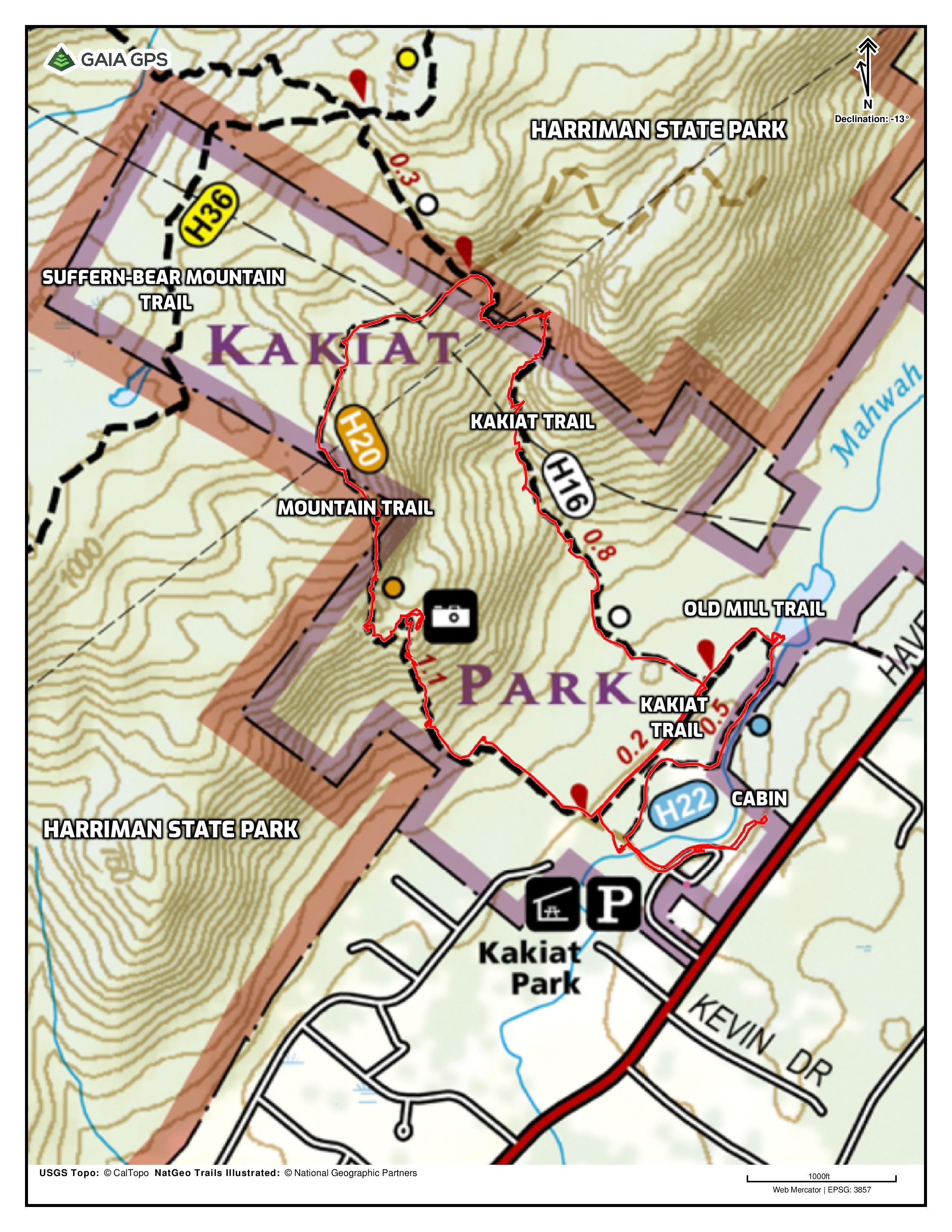
Length: approximately 3.6 miles
Max elevation: 978 ft.– total elevation gain approximately 732 ft.
Route type: Circuit
Map: Harriman-Bear Mountain Trails Map #118 – Kakiat Park Free Map
Trailhead parking: Kakiat Park – 668 Haverstraw Rd, Montebello, NY 10901
Rest Rooms: Yes
Park Overview:
Adjacent to the southeastern side of Harriman State Park, Kakiat Park is a minimally developed Rockland County park with a diverse topography, from flat wetlands to rolling hills, to steep mountainside. The Mahwah River flows southwesterly the length of the park approximately 2,500 feet. Times of heavy rains flood large areas along the river. The Ramapo fault runs through the park. Trees include Willow, Apple, Poplar, White Pine, Hemlock, Beech, Maple, White Ash, Oaks, and Dogwood.
Located off of Route 202 across from Viola School, this 376-acre park has approximately 3 miles of marked trails plus a network of unmarked woods roads that criss-cross the park. Kakiat is part of the Rockland County system of park and recreation facilities.
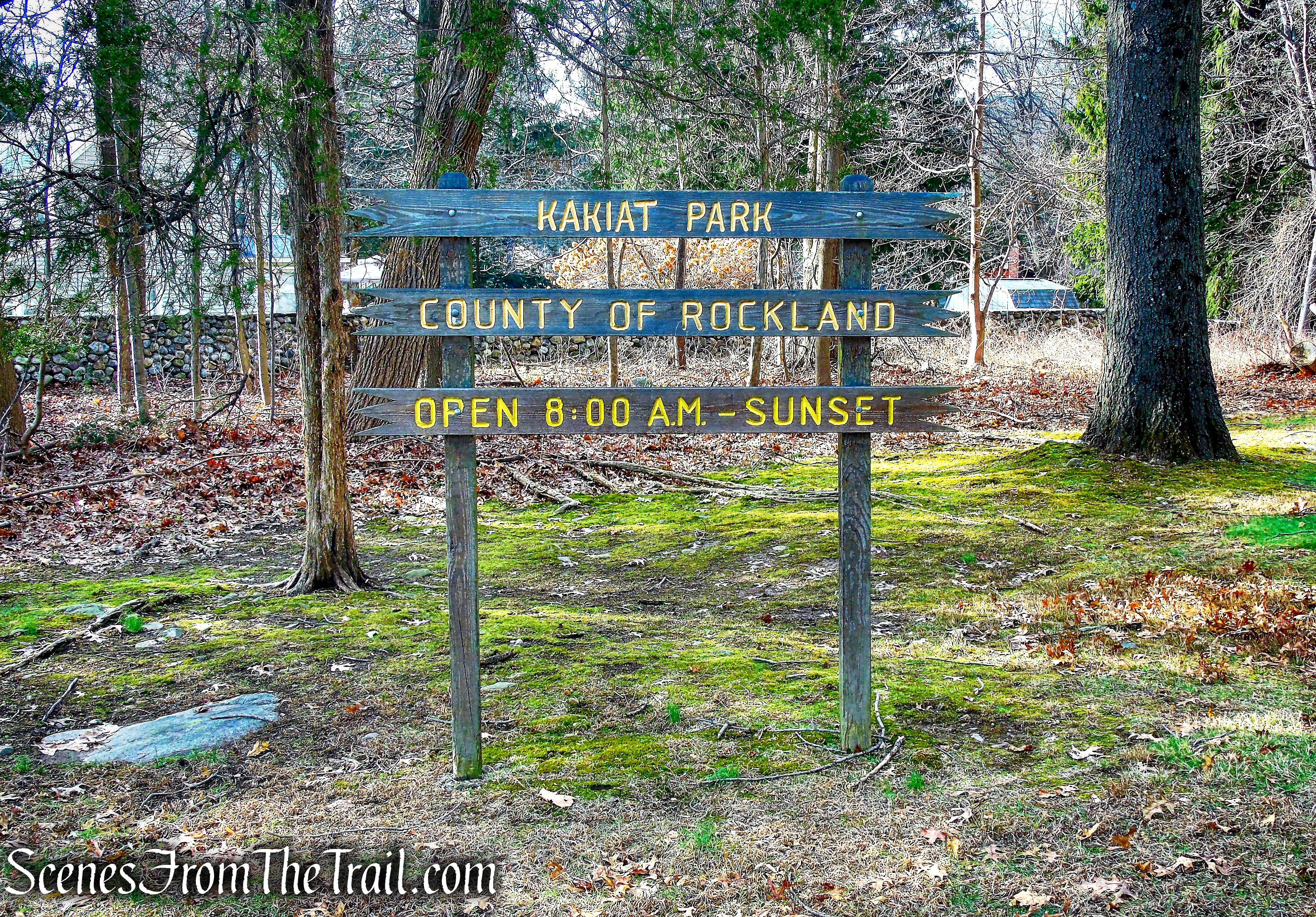
Kakiat County Park
Activities that are allowed in the park include:
Hiking (the Kakiat Trail starting from near the parking area passes through Harriman State Park and into Dater Mountain County Park), horseback riding, picnicking, and scenic lookouts. An off-leash dog area is located near the parking lot. A footbridge crosses the Mahwah River, which is stocked annually with trout; a picnic pavilion can be found near the river. Numerous winter activities exist along with active wildlife and forestry conservation projects. Guided tours are available by the Park Rangers.

Mahwah River – Kakiat County Park
Please note: During the spring and summer months, be observant when hiking. Both Timber Rattlesnakes and Copperheads are known to inhabit the area. Also, ticks are common and they may carry Lyme Disease.

Kakiat County Park
History:
Kakiat, in the original Algonquin tongue, means a neck of land between two hills. It was originally spelled Kackyacktaweke, but shortened for obvious reasons. Kakiat Park is part of the Harris patent, one of the original land patents from the King of England. Also known as Kakiat Farm, the home of the Blauvelt family who owned and farmed the land for over two hundred years, growing apples, peaches and cherries.
Also the site of the Blauvelt Mill, the foundation of which still remains. Originally the farm included over 1,800-acres. An 1854 map shows the present park property as the “Blauvelt works” which was a foundry and a saw mill.

Blauvelt Mill ruins – Kakiat Park
This region, once known as Kakiat, was later named New Hempstead by settlers from Long Island. Eventually it became the Town of Ramapo.
A log cabin constructed in 1922 stands as a mute reminder of the simple life of 100 years ago.

1922 Log Cabin – Kakiat Park
The National Recreation Association in 1961 recommended its purchase to the County Board of Supervisors. As a result a formally appointed Park Commission was installed and the process of acquiring land for park purposes began. The property officially became county parkland in 1972.
Trails Overview:
The Kakiat Trail (white 1.1 miles in Kakiat Park) begins just northwest of the parking area and climbs the escarpment, where it enters Harriman State Park, on its way to Dater Mountain Nature Park and Tuxedo.

Kakiat Trail – Kakiat County Park
There are two other short trails in the park: the Old Mill Trail (blue 0.5 mile), which runs along the Mahwah River to the ruins of the Blauvelt Mill,
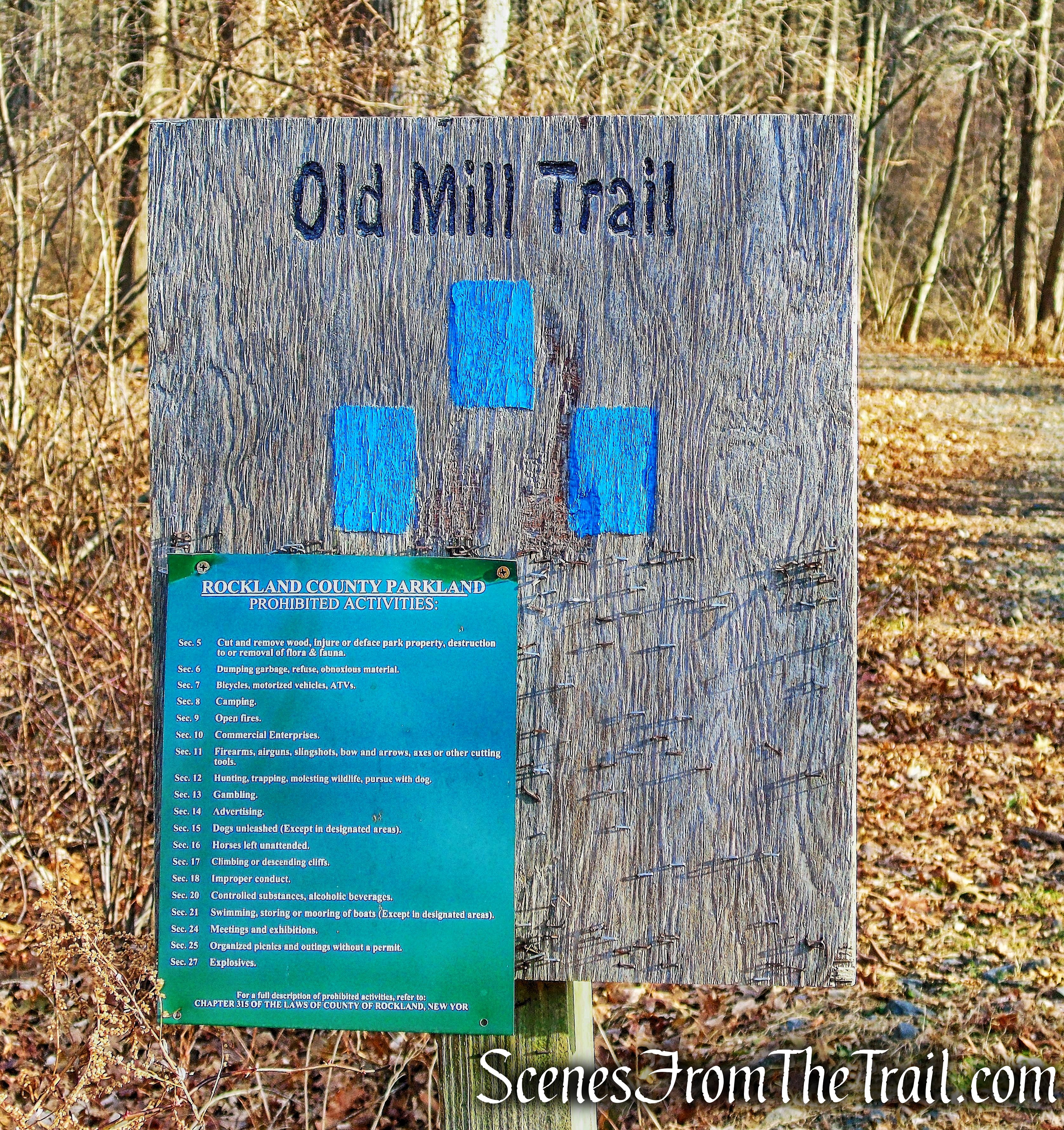
Old Mill Trail – Kakiat County Park
and the Mountain Trail (orange 1.1 miles), which ascends the escarpment to a panoramic viewpoint from where the Manhattan skyline is visible.

Mountain Trail – Kakiat County Park
A short section of the Suffern-Bear Mountain Trail (yellow) crosses the western portion of Kakiat County Park. There are a number of unmarked woods roads that criss-cross the park which are not on the NY-NJ Trail Conference map, but are shown on the free web map. Several utility easements traverse the park as well.

Kakiat County Park
Hike Overview:
There is ample parking and restrooms available on site. This hike covers most if not all of the points of interest in the park. The blazed trails that climb the escarpment are a combination of rocky footpaths and eroded woods roads that after heavy or prolonged rain, have standing or running water on them. Apart from the section nearest the parking area, the park does not seem to be heavily used. We encountered a lone hiker with their dog at the first viewpoint and no one else on any of the trails until we stopped by the river, near the end of the hike.
Kakiat County Park
The Hike:
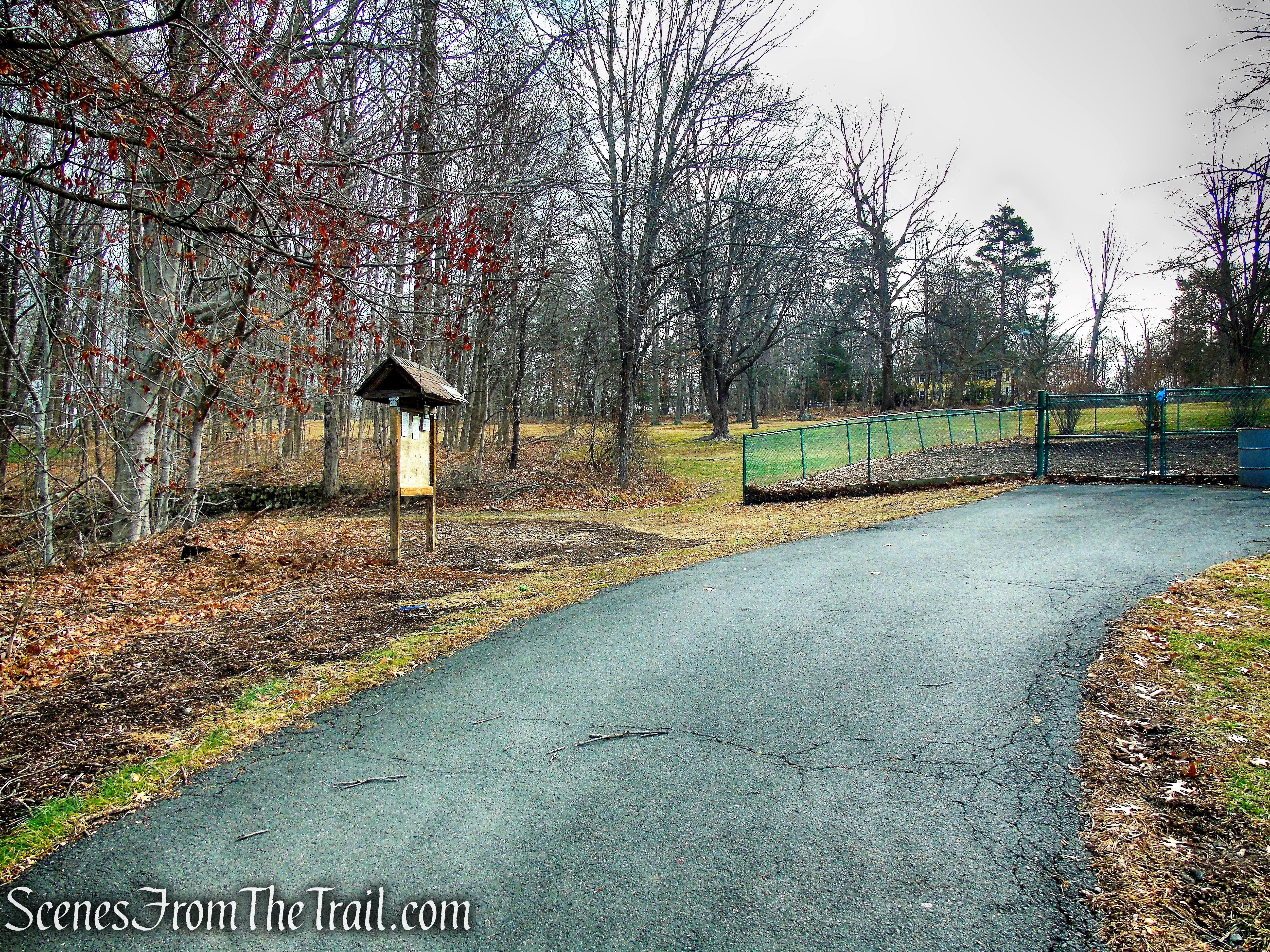
At the northeast end of the parking lot, between a kiosk and the dog park, there is an old woods road. Follow the unmarked road which runs alongside the Mahwah River for about 300 feet, a log cabin that was built in 1922, sits just uphill from the road. When you are done checking out this historic cabin, return to the woods road and retrace your steps back to the parking lot.
Kakiat County Park

unmarked woods road – Kakiat County Park

walk uphill to the 1922 Log Cabin – Kakiat Park

1922 Log Cabin – Kakiat Park
1922 Log Cabin – Kakiat Park

Kakiat County Park
Walk across the parking lot towards the entrance road. Turn right onto a park road with a decorative metal gate. Walk around the gate and proceed ahead on the paved park road, soon crossing a footbridge over the Mahwah River. In a short distance, turn right on the first gravel road.
bear right at the southwest end of the parking lot
Proceed on the paved walk past the metal gate
Kakiat County Park

cross the footbridge over the Mahwah River
Mahwah River – Kakiat Park
turn right on the Old Mill Trail
This is the start of the blue-blazed Old Mill Trail. Follow the blue blazes along the gravel road which run parallel to the river. Soon the gravel road ends and the trail becomes a dirt road. The trail curves along the contour of the river, turns right approaching the river then turns left, hugging the shoreline and crosses a stream that flows into the Mahwah River.
Old Mill Trail – Kakiat Park

Old Mill Trail – Kakiat Park
Old Mill Trail – Kakiat Park

Old Mill Trail – Kakiat Park
Old Mill Trail – Kakiat Park
In about 500 feet, the trail passes by the Blauvelt Mill Ruins. This was the site of a foundry and a saw mill. You may want to take a little time to explore these interesting ruins.

Blauvelt Mill Ruins – Kakiat Park
Blauvelt Mill Ruins – Kakiat Park
Blauvelt Mill Ruins – Kakiat Park
Blauvelt Mill Ruins – Kakiat Park

Blauvelt Mill Ruins – Kakiat Park
Blauvelt Mill Ruins – Kakiat Park
When you are ready to continue, proceed ahead on Old Mill Trail as it heads away from the river and then turns left. The trail now heads southwest and crosses a wooden footbridge recrossing the same stream from earlier. Just ahead, the blue-blazed Old Mill Trail ends as the white-blazed Kakiat Trail comes in from the right.
Old Mill Trail – Kakiat County Park

Old Mill Trail – Kakiat County Park

Old Mill Trail – Kakiat County Park
terminus of Old Mill Trail
Continue straight ahead on the level woods road, now following the white blazes. In about 375 yards, the white-blazed Kakiat Trail ends at a T-intersection with a gravel park road, also the route of the orange-blazed Mountain Trail. Turn right here, now following the orange blazes as they head in a westerly direction.
Kakiat Trail – Kakiat County Park
terminus of Kakiat Trail
Keep your eyes on the orange blazes as there are several woods roads that branch off the main trail. In about 365 yards, the orange-blazed Mountain Trail crosses a Gasline Connection Road, climbs several stone steps and begins a steep and rocky ascent.
Mountain Trail – Kakiat County Park

Mountain Trail – Kakiat County Park
Mountain Trail – Kakiat County Park
Mountain Trail – Kakiat County Park

Mountain Trail – Kakiat County Park
The trail climbs steeply over rocky terrain and soon passes a large cliff face on the right. As the trail passes the cliff, the orange blazes turn left. Turn right here, leaving the trail and ascending to the top of the cliff face you just passed. You have just gained about 350 ft. of elevation in less than 1/4 of a mile. This is a good spot to take a break and enjoy the view.
Mountain Trail – Kakiat County Park
Mountain Trail – Kakiat County Park

unmarked trail to viewpoint – Kakiat County Park

first viewpoint just off the Mountain Trail

first viewpoint just off the Mountain Trail
When you are ready to continue, head back to the Mountain Trail and follow the orange blazes as the trail levels off briefly. The Mountain Trail soon turns right and continues its steep ascent of Kakiat Mountain, at times climbing over rock formations. As the trail nears the top of the ridge, views of the surrounding area start to open up.
Mountain Trail – Kakiat County Park
Mountain Trail – Kakiat County Park
Mountain Trail – Kakiat County Park
Mountain Trail – Kakiat County Park

Mountain Trail – Kakiat County Park

Mountain Trail – Kakiat County Park
large estate on Haverstraw Rd (Route 202)
Mountain Trail – Kakiat County Park

Mountain Trail – Kakiat County Park
Mountain Trail – Kakiat County Park
When the Mountain Trail reaches the top of the rise, there is a large boulder in an open area with spectacular views. This is a great spot to catch your breath and take in the views.
Mountain Trail – Kakiat County Park
The view east over Rockland and Westchester counties.

Mountain Trail – Kakiat County Park
To the south, the Manhattan skyline can be seen on a clear day.

Mountain Trail – Kakiat County Park
Looking northeast, Cobus Mountain, in Harriman State Park, is the peak on the left.

Mountain Trail – Kakiat County Park
The orange-blazed Mountain Trail continues to climb, now more gradually. The trail then briefly leaves Kakiat County Park and enters Harriman State Park, crossing under some power lines. The Mountain Trail now descends on a power line service road. Keep your eyes open for the orange blazes as the Mountain Trail turns right on a gas pipeline right of way and immediately turns left, continuing on the service road.
Mountain Trail – Kakiat County Park

Mountain Trail – Kakiat County Park

Mountain Trail – Kakiat County Park

Mountain Trail – Kakiat County Park

Mountain Trail – Kakiat County Park

Mountain Trail – Kakiat County Park
Mountain Trail – Kakiat County Park
In another 500 feet, the Mountain Trail ends at a junction with the white-blazed Kakiat Trail, once again entering Harriman State Park. Turn right and follow the white blazes as they lead downhill. After crossing under the power line, the trail descends more steeply, then enters and leaves Kakiat County Park.
terminus of Mountain Trail – Kakiat County Park

turn right on Kakiat Trail

Kakiat Trail – Kakiat County Park
Kakiat Trail – Kakiat County Park
The trail approaches a small stream, turns right and follows that stream, with some lovely cascades, down the mountain, once again entering Kakiat County Park.
Kakiat Trail – Kakiat County Park
Kakiat Trail – Kakiat County Park

Kakiat Trail – Kakiat County Park

Kakiat Trail – Kakiat County Park

Kakiat Trail – Kakiat County Park
The Kakiat Trail continues downhill on an old woods road and crosses a stream.
Kakiat Trail – Kakiat County Park
Kakiat Trail – Kakiat County Park

Kakiat Trail – Kakiat County Park
The Kakiat Trail turns right onto a gas pipeline and almost immediately turns left (look carefully here for the blazes).

Kakiat Trail – Kakiat County Park

Kakiat Trail – Kakiat County Park
The Kakiat Trail now follows a footpath and after almost a mile from when you first started following the white blazes, the trail turns right onto the woods road at the junction with the Old Mill Trail. Turn right and follow the white blazes on the same woods road that you walked earlier in the hike.
Kakiat Trail – Kakiat County Park

Kakiat Trail – Kakiat County Park
In another 375 yards the Kakiat Trail ends at a T-intersection with a gravel park road, also the route of the orange-blazed Mountain Trail. Turn left here and follow the gravel road southeast, crossing the footbridge over the Mahwah River, past the metal gate and back to the parking lot, where the hike began.

terminus of Kakiat Trail – Kakiat County Park

terminus of Mountain Trail – Kakiat County Park
bridge over the Mahwah River – Kakiat County Park

Kakiat County Park
Kakiat County Park
Review:
A good mix of woods roads and rugged trails over rocky terrain. The views from the Mountain Trail are worth the steep climb. The trails are well blazed except for some sections in the area of the power lines, where there are no trees. There, the blazes are painted on the occasional boulder or on the ground. These may be difficult to see when there is snow. The Kakiat Trail was wet in some sections, but that could be a seasonal issue. The Blauvelt Mill Ruins are quite interesting and should not be missed. Only saw one hiker at the first viewpoint and none after that, until the end of the hike, near the Mahwah River.
Pros:
Historical features, Blauvelt Mill Ruins, 1922 cabin, scenic views, well blazed trails, lesser traveled area, rugged landscape.
Cons:
Area near the Mahwah River attracts crowds.
Take a hike!

Kakiat County Park
Sources:
- Myles, William J.. Harriman Trails: A Guide and History . New York – New Jersey Trail Conference. Kindle Edition
- NY-NJ Trail Conference
- County of Rockland, NY – Kakiat Park
