January 1, 2020 – Garrison, NY
Difficulty: Moderate
Length: Approximately 3 miles
Max elevation: 910 ft. – total elevation gain: approximately 808 ft.
Route type: Out and back
Map: East Hudson Trails Map #101
Trailhead parking: Anthony’s Nose Trailhead – 171-143 Bear Mountain-Beacon Hwy, Garrison, NY 10524
Please Note: Parking is along the side of Route 9D, which at times is very busy. Please make sure that you park with all four tires off the pavement or you may get ticketed. Use caution while walking alongside the road to and from the trailhead.
Details on hikes to Anthony’s Nose via different routes:
- Anthony’s Nose via Military Road
- Camp Smith Trail
- Anthony’s Nose Rock Scramble
- Anthony’s Nose from South Mountain Pass
- Anthony’s Nose from Route 202
Overview:
Anthony’s Nose is a peak along the Hudson River at the north end of Westchester County, New York. Together with Dunderberg Mountain, it comprises the South Gate of the Hudson Highlands. The 910 ft. peak has been known as Anthony’s Nose since at least 1697, when the name appears on a grant patent. Pierre Van Cortlandt, who owned this mountain, said it was named for a pre-Revolutionary War sea captain, Anthony Hogan. This captain was reputed to have a Cyrano de Bergerac type nose.

Anthony’s Nose as viewed from Bear Mountain
Anthony’s Nose is one of the more popular hikes in the Hudson Valley and on weekends the cars are lined up along Route 9D as a testament to its popularity. The short, but steep hike to the summit offers some spectacular views up and down the Hudson River. There are several approaches to the summit with varying degrees of difficulty, but none are easy due to the sometimes rough terrain and/or sudden elevation gain. Due to the crowds, this is a hike better done on weekdays.
Hike Overview:
Although there are several routes that one could take to reach the summit of Anthony’s Nose, this one seems to be the most popular. This is a straightforward out and back hike using the Appalachian Trail and the Camp Smith Trail. Both trails are well marked and easy to follow. The spectacular Hudson River Valley views is what makes this hike so popular and it is a good idea to get an early start if you don’t want to share the summit with hordes of people.

Anthony’s Nose from Route 9D

elevation graph – Anthony’s Nose
The Hike:
The trailhead for this hike is right near the green Putnam County sign on the mountain side of the road. Proceed past the wooden kiosk and begin following the white blazes of the Appalachian Trail (AT). The trail immediately starts its steep ascent of Anthony’s Nose. Pay attention to the white blazes as there are several unmarked footpaths that branch off of the AT.

Route 9D trailhead – Anthony’s Nose

Appalachian Trail – Anthony’s Nose

Appalachian Trail – Anthony’s Nose

Appalachian Trail – Anthony’s Nose

Appalachian Trail – Anthony’s Nose

Appalachian Trail – Anthony’s Nose
The rocky footpath heads northeast up the mountain with occasional stone steps to make the footing a little easier. As the AT continues to climb steeply, it threads its way through a boulder field.

Appalachian Trail – Anthony’s Nose

Appalachian Trail – Anthony’s Nose

Appalachian Trail – Anthony’s Nose

Appalachian Trail – Anthony’s Nose

Appalachian Trail – Anthony’s Nose

Appalachian Trail – Anthony’s Nose
In about 0.4 mile from Route 9D and almost 400 feet of elevation gain, the white blazes of the Appalachian Trail turn left on a woods road and the Camp Smith Trail begins on the right. Turn RIGHT on the woods road, now following the blue blazes of the Camp Smith Trail.

turn right onto Camp Smith Trail
The blue-blazed Camp Smith Trail continues to climb, but on a more moderate grade. Continue along this woods road following the blue blazes, now heading southwest. In about 0.2 mile you’ll pass a small pond on the left.

Camp Smith Trail – Anthony’s Nose

Camp Smith Trail – Anthony’s Nose

Camp Smith Trail – Anthony’s Nose

Camp Smith Trail – Anthony’s Nose

Camp Smith Trail – Anthony’s Nose
In just over a 1/2 a mile from the junction with the AT, the Camp Smith Trail turns left. There is a short spur trail on the right that is blazed blue as well. Turn right and follow the trail to a large rock outcrop, marked by a flagpole, with expansive views over the Hudson River.

turn right towards the summit of Anthony’s Nose
Update: A sign is now in place at this junction, pointing the way to the overlook.
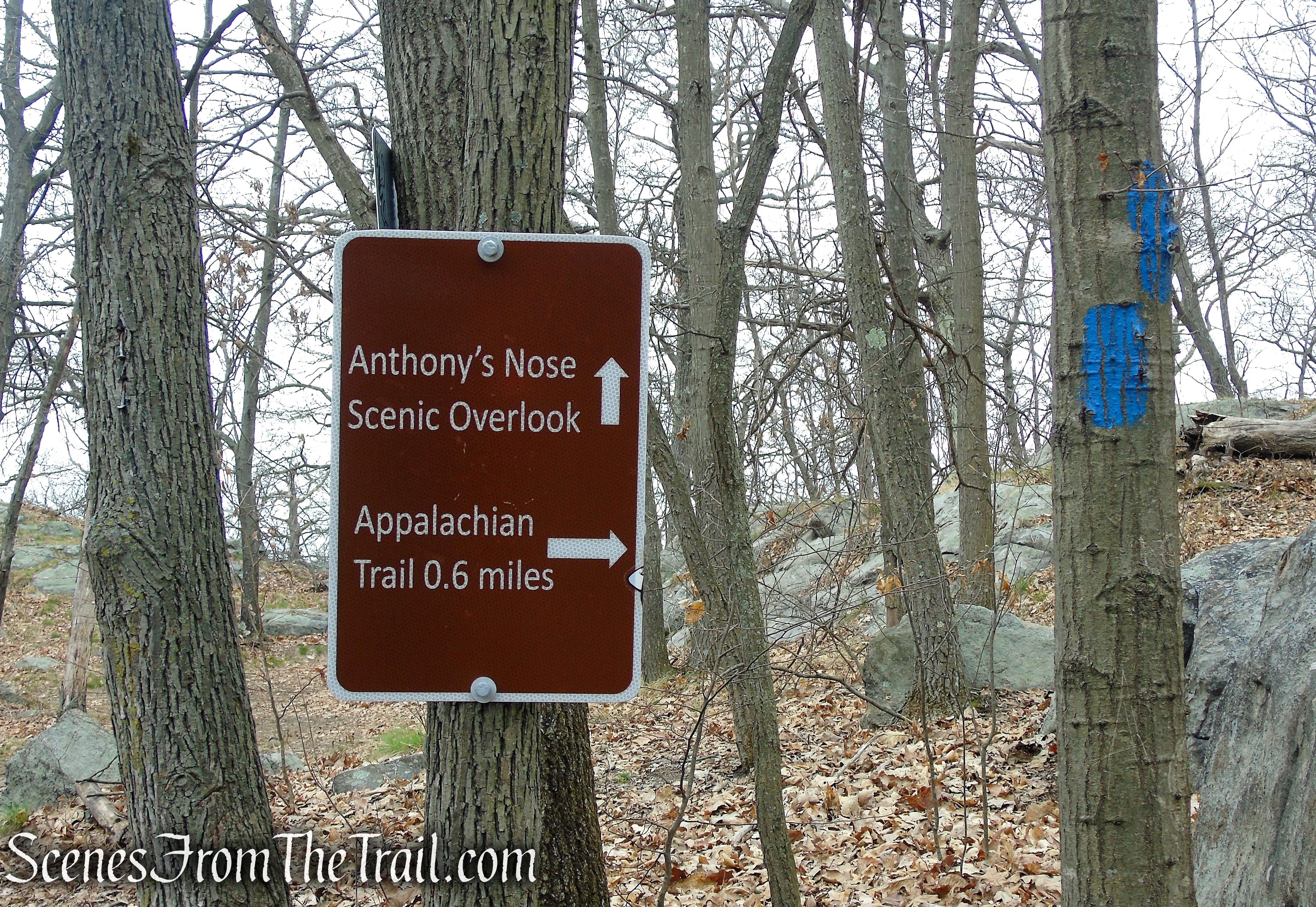
turn right to Anthony’s Nose Overlook
Directly across the Hudson River is Bear Mountain with Hessian Lake visible at its base.

Anthony’s Nose – East Hudson Highlands
To the South, Iona Island can be seen down below with Dunderberg, Bald, The Timp and West Mountains just beyond.

Anthony’s Nose – East Hudson Highlands
A memorial for the fallen at the base of the flagpole.

Anthony’s Nose – East Hudson Highlands
The Bear Mountain Bridge just below to the right.

Anthony’s Nose – East Hudson Highlands
A more southward view of the Hudson River with Dunderberg Mountain seemingly jutting out of the river.

Anthony’s Nose – East Hudson Highlands
When you are done enjoying the Hudson River Valley views, retrace your steps to the Camp Smith Trail. Proceed ahead towards the large rock formation in front of you. Follow the blue blazes as they climb to the true summit of Anthony’s Nose.

Camp Smith Trail – Anthony’s Nose

Camp Smith Trail – Anthony’s Nose
There is a south-facing view from the summit, albeit not as good as from the lookout, but you can see past Dunderberg Mountain farther down the Hudson River.

Camp Smith Trail – Anthony’s Nose
When you are done checking out this view, retrace your steps back towards the first lookout, but turn right on the woods road (Camp Smith Trail), now heading northeast. In about 400 feet or so, look for an unmarked footpath on the left. This trail leads to the site of an old Airway Beacon that once stood guard on Anthony’s Nose. The concrete footings along with two survey markers are still there.

Air Beacon Trail – Anthony’s Nose

Air Beacon Trail – Anthony’s Nose

Air Beacon Trail – Anthony’s Nose

survey marker – Anthony’s Nose
Proceed past the concrete footings a short distance to a large slanted rock slab, with views to the north of the Hudson River.

north-facing viewpoint – Anthony’s Nose

north-facing viewpoint – Anthony’s Nose
The third survey marker.

survey marker – Anthony’s Nose
When you are ready to proceed, retrace your steps along the unmarked footpath, back to the blue-blazed Camp Smith Trail and turn left. Follow the woods road as it descends, now retracing your steps.

Air Beacon Trail – Anthony’s Nose

Camp Smith Trail – Anthony’s Nose
Follow the blue blazes for about another 1/2 mile, where the Camp Smith Trail ends at the junction with the Appalachian Trail. TURN LEFT and follow the white blazes of the AT as they lead steeply downhill. If you find yourself walking uphill on the woods road, you have missed the turn. Keep an eye out for this turn otherwise you will continue going north on the AT and wind up on South Mountain Pass Road, far from where you parked your vehicle.

turn left on Appalachian Trail
Follow the white blazes as they lead steeply downhill back to Route 9D, where the hike began.

Appalachian Trail – Anthony’s Nose
Review:
This is a fun hike to do, with outstanding views of the Hudson River Valley as the payoff. The flagpole area at the summit is a popular spot for hikers, so if you’re looking for solitude, this may not be the hike for you. This hike is best done on a weekday when there are less people on the trails. Nevertheless it’s worth the time and effort. For a slightly longer hike, you can park near Hessian Lake in Bear Mountain and follow the Appalachian Trail as it winds it’s way through the Trailside Museums & Zoo, across the Bear Mountain Bridge, to Anthony’s Nose.
Pros:
Anthony’s Nose, American Flag, Hudson Valley views, Hudson River.
Cons:
Popular spot that does get crowded.
Take a hike!

Anthony’s Nose from Route 9D
