April 5, 2020 – Irvington, NY
Rehiked: November 16, 2025
Difficulty: Moderate
Length: Approximately 5.5 miles
Max elevation: 528 ft. – total elevation gain: approximately 763 ft.
Route type: Out and Back
Map: Taxter Ridge Park Preserve Trail Map
Trailhead parking: Taxter Ridge Preserve Parking – Irvington, NY 10533
Update:
I rehiked the preserve on November 16, 2025, and noticed that the trails are no longer well-marked. Many of the blazes have faded and could use some fresh paint. Since I’ve been here before, I’m familiar with the layout and didn’t have much difficulty navigating.
Park Overview:
The unique horseshoe shaped park is located south of Interstate 287 on the Tarrytown-Irvington border and is the largest tract of undeveloped land in Westchester County. Considered the “Gateway to Westchester,” the 199-acre property has a stunning topography. The ridge, a natural rock ledge, is a prominent geographical feature in the land that is protected as open space. Taxter Ridge Park Preserve’s landscape features rock ledges, woodlands, streams, wetlands and old growth forest. Previously considered for development, the site links 400 acres of existing municipal parkland and another 45 acres in the Town of Irvington.
Taxter Ridge Park Preserve is operated and managed by the Town of Greenburgh.
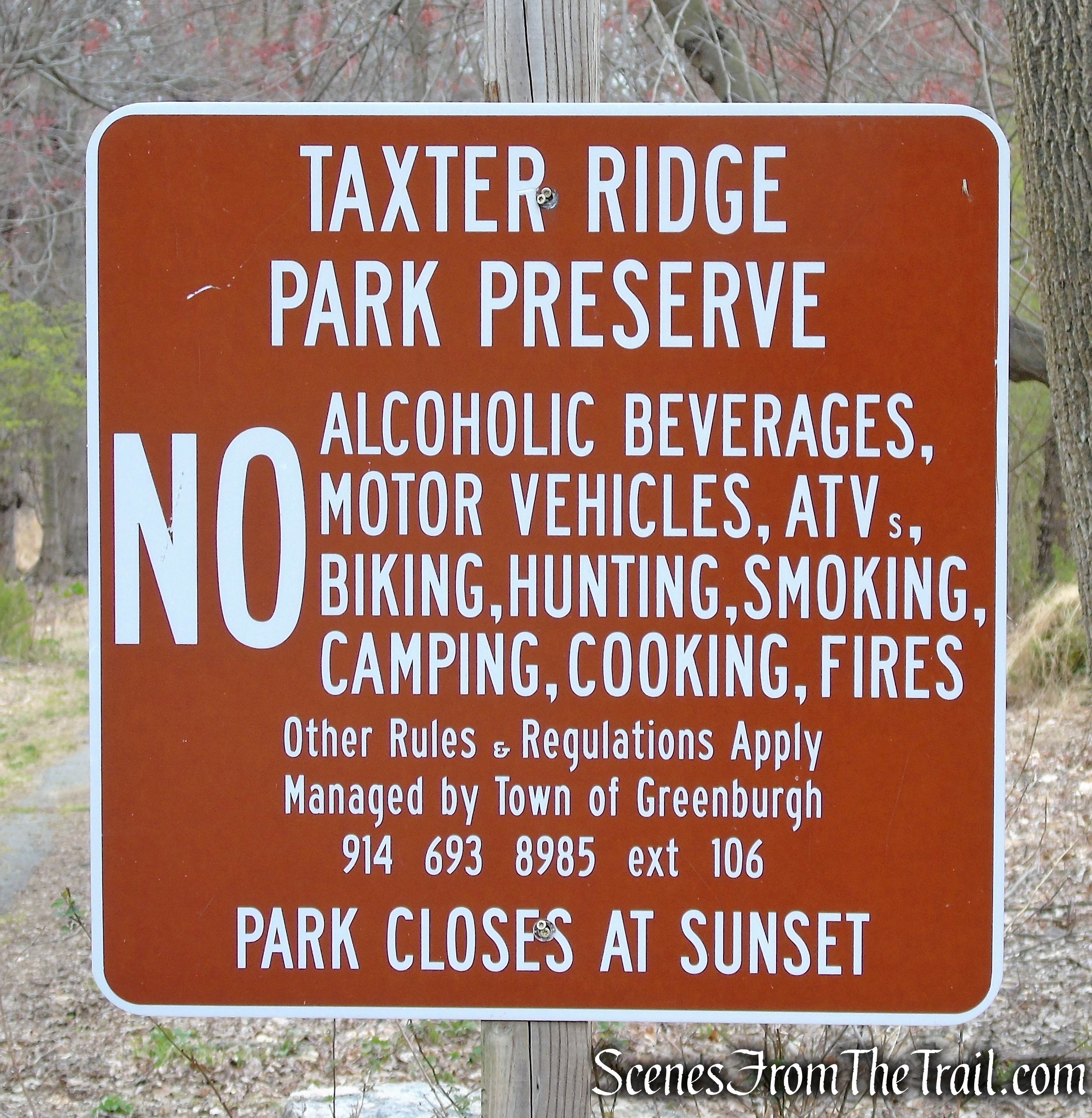
Taxter Ridge Park Preserve
History:
On the northern section of the property was Helen Gould’s (1868-1938) “Woody Crest” (sometimes spelled Woodycrest), a charming old colonial place near her own country home at Lyndhurst. The first-born daughter of Jay Gould, she was involved in numerous philanthropic works during her lifetime. Woody Crest was a collection of fields and orchards, set aside by the young heiress as a Fresh Air Farm for crippled children. There she cared for the little ones year round.
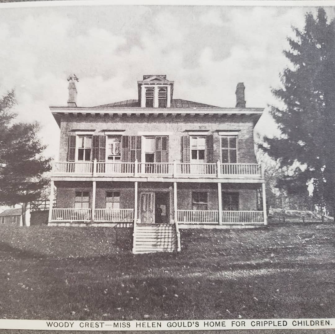
Woody Crest
From July 1st to October 1st it received for two weeks, children sent by various missions, hospitals, societies, etc. of New York City. From October to July it received convalescent crippled children for longer periods as they may require. Capacity was 17 beds in summer and 15 beds in winter.

Woody Crest Boulder
Woody Crest stood on the crest of a wooded hill about two miles from the Hudson River to the west and the Saw Mill River to the east. The front porch overlooked a tract of low-lying land green with grass and springing wheat, and shaded by groves. In the distance was the flow of the Hudson River with dark mountains for a background. Miss Gould bought the house, with thirteen acres of land surrounding it in 1893 and operated Woody Crest from about 1900 to about 1920.

Woody Crest
Taxter Ridge was once part of the hundreds of acres owned by Rev. Sun Myung Moon’s Unification Church. In 2004, the Trust for Public Land (TPL) negotiated the purchase agreement among New York State, Westchester County and the Town of Greenburgh, with each contributing one-third of the purchase price. The Village of Tarrytown also acquired a 17-acre portion as part of the agreement. The state’s share of the total $10.9 million purchase was $3.6 million, which was provided through the State’s Environmental Protection Fund (EPF). This is the largest acquisition of open space in Greenburgh history. The purchase of Taxter Ridge was the culmination of a three-year effort that included lobbying by a group of area citizens, the Committee to Preserve Taxter Ridge, that fought to preserve the land.
Trails Overview:
There are three official access points to Taxter Ridge Park Preserve. The newly built parking lot on Taxter Road (2017), Sheldon Avenue and Mt. Pleasant Lane.
There are four blazed trails in the preserve that meander their way through the hilly terrain and old growth forest. Some interesting features include: deep ravines, glacial rock formations, wetlands, stone walls and several brick walls and foundations.
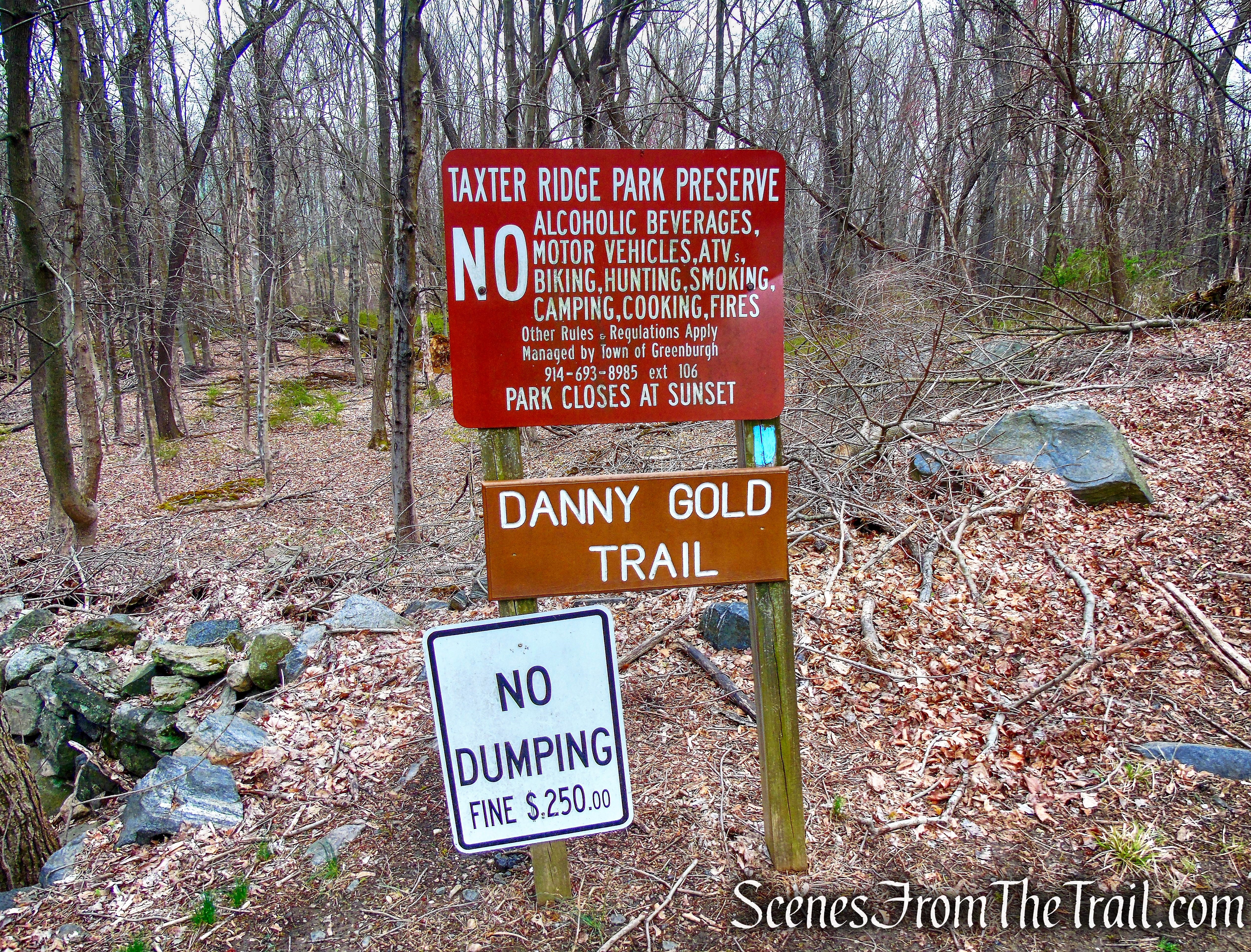
When the Yellow Trail ends at the junction with the Blue Trail, The Blue Trail goes both left and right, it is somewhat misleading. It gives the impression that the Blue Trail is a loop. It is not. There are two legs to the Blue Trail if coming from the Taxter Road Trailhead. The left leg ends at Mt. Pleasant Lane and the right leg runs for about a 1/4 mile, then abruptly ends where the Orange Trail begins. In my opinion, the right leg of the Blue Trail should be reblazed in orange to better distinguish that it is not a loop trail.
The Yellow Trail (0.2 mile) is accessible from Taxter Road Trailhead parking lot (7 spaces) and is used to connect to the Blue Trail.
Taxter Road Trailhead
From Mt. Pleasant Lane (street parking) follow the Blue Trail (Danny Gold Trail) through the woods for 1.5 miles. The trail passes by a 250 year-old oak tree and a deep ravine. From this direction, the Blue Trail passes junctions with the Pink Trail and the Yellow Trail, ending at the Orange Trail.
Mt. Pleasant Lane Trailhead
From the end of Sheldon Avenue (dead end street) in Tarrytown, the Orange Trail (1 mile) meanders up and down hills. Initially it is on a graded woods road. A bit after it becomes a single track, until it meets the blue-blazed trail from Mt Pleasant Lane. Sections away from the NYS Thruway are quiet.
Sheldon Avenue Trailhead
The Pink Trail (0.2 mile) serves as a connector between two sections of the Blue Trail at the top of the ridge near Taxter Road. The Pink Trail is not shown on the current trail map.
Pink Trail
Hike Overview:
Since the property is horseshoe shaped, the only way to do a true loop hike is to utilize public streets. I wanted to remain in the preserve and hit every marked trail. So from the Taxter Road Trailhead, we took the short Yellow Trail uphill to the ridge to the T-intersection with the Danny Gold Blue Trail. Here the Blue Trail goes both left and right. We hiked the left leg first, taking it all the way to Mt. Pleasant Lane then retracing our steps back on Blue, turning left on the Pink Trail, then Left on Blue. We then took the Blue Trail until it meets the Orange Trail and took that all the way to Sheldon Avenue. From there we retraced our steps on Orange to Blue and then left on Yellow returning to the parking area. This hike also includes some off trail exploration.

Taxter Ridge Park Preserve
The Hike:
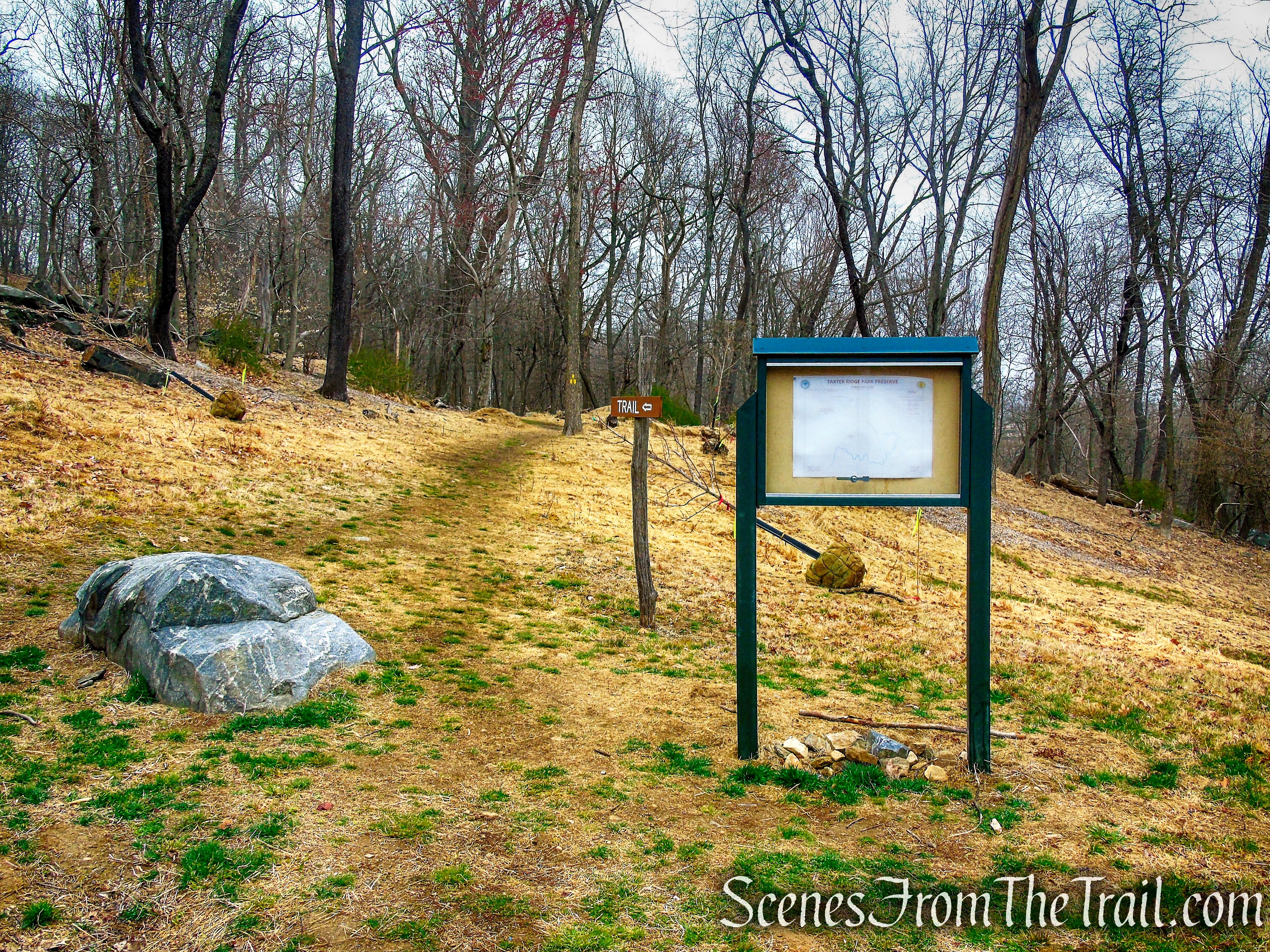
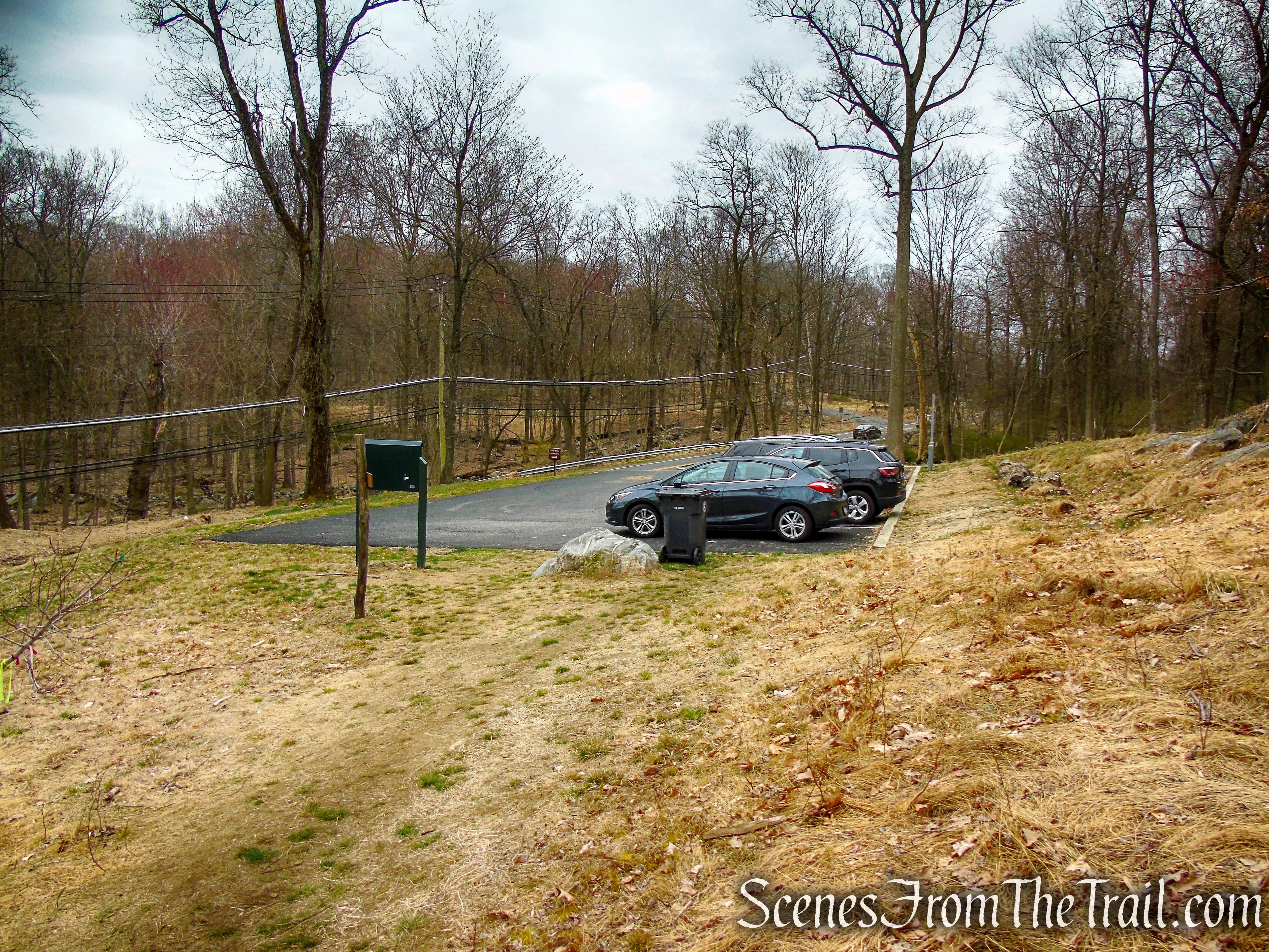
This hike begins at the Taxter Road Trailhead. The parking lot has 6 spaces plus 1 handicapped spot.
Taxter Road Trailhead
At the far end of the parking area, walk between a rock and the kiosk. You may want to take a look at the faded map at the kiosk and photograph it for later reference, but it does not include the Pink Trail and where the Blue and Orange Trails connect may be slightly off. Walk along the grass and look for three yellow blazes on a tree at the edge of the woods. Follow the yellow blazes as they head downhill briefly then climbs on switchbacks towards the top of the ridge.
Taxter Road Trailhead
Yellow Trail – Taxter Ridge Park Preserve
Yellow Trail – Taxter Ridge Park Preserve
Yellow Trail – Taxter Ridge Park Preserve
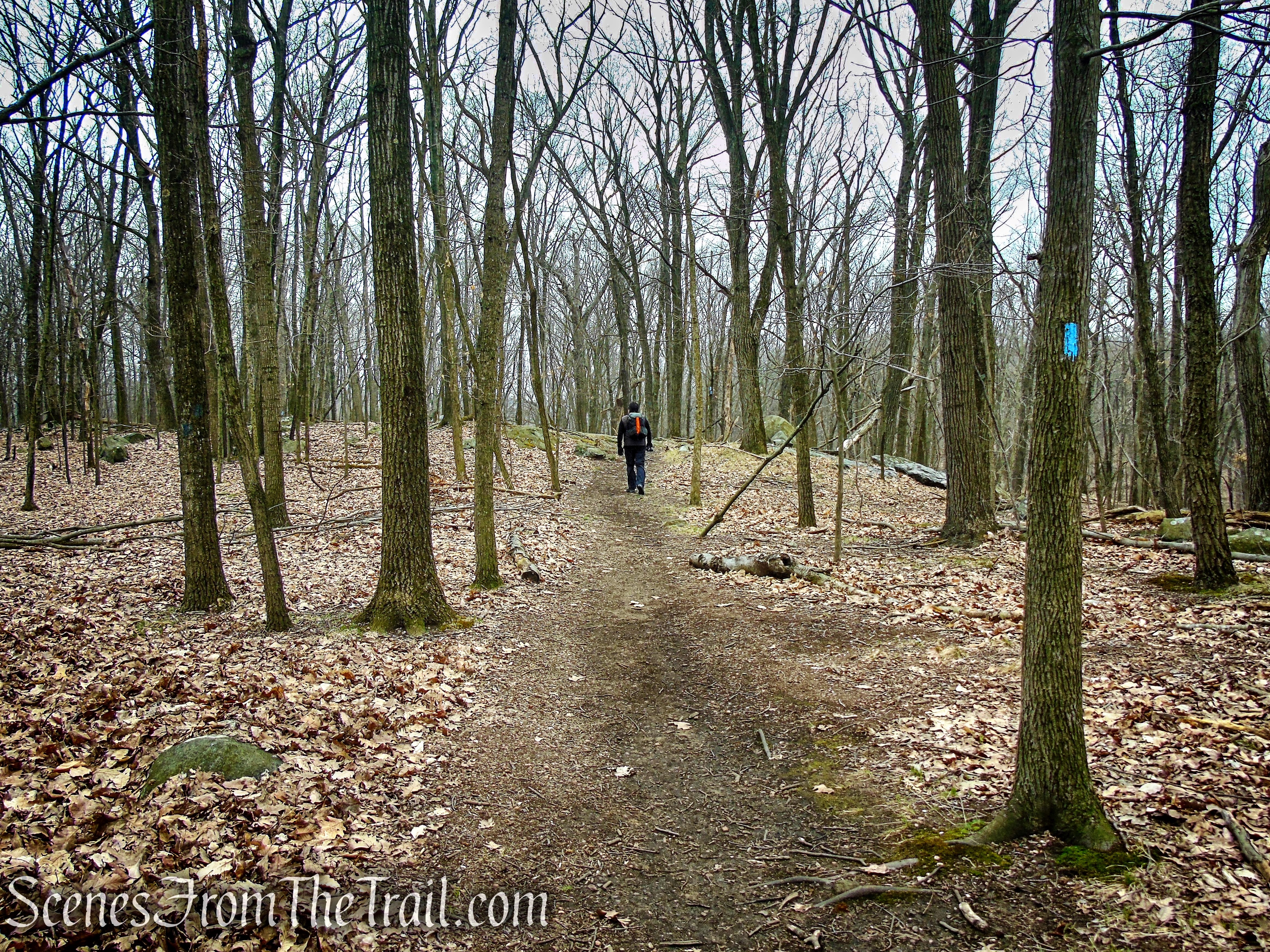
In about 0.2 mile, the Yellow Trail ends at a T-intersection with the Blue Trail. Turn left, now following the blue blazes as they head southwest just below the ridge. You will be following the blue blazes for approximately the next two miles (there and back). In a short distance the Blue Trail turns right and goes around a rock ledge, ascending to the top of the ridge.
terminus of Yellow Trail
turn left on Blue Trail
Blue Trail – Taxter Ridge Park Preserve
Blue Trail – Taxter Ridge Park Preserve
Blue Trail – Taxter Ridge Park Preserve
Blue Trail – Taxter Ridge Park Preserve
The Blue Trail continues southwest, passing a split boulder with a tree sticking out of it then the junction with the Pink Trail. Continue following the blue blazes as the trail snakes its way through the woods. Soon the trail descends a little, turns right then descends more steeply into a ravine. At the base of the descent there is a wet area just below the rock face that the trail descended from.
Blue Trail – Taxter Ridge Park Preserve
Blue Trail – Taxter Ridge Park Preserve
Blue Trail – Taxter Ridge Park Preserve
Blue Trail – Taxter Ridge Park Preserve
Blue Trail – Taxter Ridge Park Preserve
Blue Trail – Taxter Ridge Park Preserve
The Blue Trail passes through a stone wall with houses visible in the distance to the left. The trail then climbs slightly, levels off then descends slightly and borders private property. The luxury homes that can be seen on the other side of the black fence are in the Greystone On Hudson development. The trail soon veers left and heads south, ending at Mt. Pleasant Lane.
Blue Trail – Taxter Ridge Park Preserve
Mt Pleasant Lane Trailhead
Now retracing our steps on Blue, we turned left on the paved road and made a short detour up to the water tower. As we neared the water tower an Opossum crossed the paved road in front of us and scurried into the woods. We then walked back down the paved road and returned to the Blue Trail, once again retracing our steps.
village of Tarrytown water tank
The four million gallon high-service water tank has been a reservoir for the needs of village of Tarrytown residents and businesses for about 50 years.
village of Tarrytown water tank
Blue Trail – Taxter Ridge Park Preserve
Blue Trail – Taxter Ridge Park Preserve
Blue Trail – Taxter Ridge Park Preserve
After the trail descends to the wet area and ascends steeply around the large rock face, it continues to climb more gradually. A short distance later, in the woods to the right (south), I spotted some ruined structures and we left the trail to take a look.
Blue Trail – Taxter Ridge Park Preserve
off trail ruins – Taxter Ridge Park Preserve
off trail ruins – Taxter Ridge Park Preserve
off trail ruins – Taxter Ridge Park Preserve
off trail ruins – Taxter Ridge Park Preserve
off trail ruins – Taxter Ridge Park Preserve
Returning to the Blue Trail, we continued retracing our steps until we came to the Y-intersection with the Pink Trail and turned left. The Pink Trail parallels the Blue Trail, but a little farther down the west side of the hill. In about 0.2 mile, The Pink Trail ends at a T-intersection with the Blue Trail, near a stone wall. Turning left, now following the blue blazes.
Blue Trail – Taxter Ridge Park Preserve
Blue Trail – Taxter Ridge Park Preserve
turn left on Pink Trail
Pink Trail – Taxter Ridge Park Preserve
Pink Trail – Taxter Ridge Park Preserve
terminus of Pink Trail
The Blue Trail descends gradually at first, then more steeply into a valley. At the base of the descent, the Blue Trail ends and the Orange Trail begins.
Blue Trail – Taxter Ridge Park Preserve
Blue Trail – Taxter Ridge Park Preserve
Blue Trail – Taxter Ridge Park Preserve
terminus of Blue Trail
The Orange Trail climbs out of the valley, levels off then climbs again and goes around some large rock formations. As the trail levels off again, it becomes a well graded dirt road and just to the right of the trail is a brick chimney.
Orange Trail – Taxter Ridge Park Preserve
Orange Trail – Taxter Ridge Park Preserve
Orange Trail – Taxter Ridge Park Preserve
Orange Trail – Taxter Ridge Park Preserve
Orange Trail – Taxter Ridge Park Preserve
Take a closer look in the vicinity of this sign, and you may discover remnants of Woody Crest quietly scattered throughout the woods.
Woody Crest sign

Orange Trail – Taxter Ridge Park Preserve
This is what’s left of “Woody Crest,” Helen Gould’s home for handicapped children from about 1900 to about 1920. You may want to take a little time to explore the area.
Woody Crest ruins – Taxter Ridge Park Preserve
Just below the road (south) is a brick structure.
Woody Crest ruins – Taxter Ridge Park Preserve
You can see the chimney in the background in the center of the image below.
Woody Crest ruins – Taxter Ridge Park Preserve
There are what appear to be some old and rusted wash basins resting among the bricks.
Woody Crest ruins – Taxter Ridge Park Preserve
An old stone lined well that is nearby.
Woody Crest ruins – Taxter Ridge Park Preserve
When you are ready to proceed, continue following the orange blazes on the graded road, keeping your eyes open for remnants of the former home on either side of the trail.
Orange Trail – Taxter Ridge Park Preserve
Orange Trail – Taxter Ridge Park Preserve
“The Boulder” is depicted in a photograph from 1905 (see History section above) with Miss Gould and the children posing alongside it.
The Boulder – Taxter Ridge Park Preserve
A stone and brick foundation nearby.
Woody Crest ruins – Taxter Ridge Park Preserve
Woody Crest ruins – Taxter Ridge Park Preserve

Woody Crest ruins – Taxter Ridge Park Preserve
The Orange Trail continues downhill along the road that was once the entrance to Woody Crest. The big looping switchbacks were created to reduce the steepness of the road in order to make it easier for vehicles and/or carriages to ascend and descend the hill.
Orange Trail – Taxter Ridge Park Preserve
Orange Trail – Taxter Ridge Park Preserve
The Boulder rests precariously up above.
Orange Trail – Taxter Ridge Park Preserve
As the Orange Trail loops around, it heads north towards Interstate 287, passing wetlands on the left. The trail turns left as it approaches the thruway and heads in a westerly direction until its terminus at Sheldon Avenue.
Orange Trail – Taxter Ridge Park Preserve
terminus of Orange Trail at Sheldon Ave.
Retracing steps back up towards Woody Crest and continued on the Orange Trail until its terminus at the Blue Trail. Following the Blue Trail back up the hill, past the junction with the Pink Trail, through a stone wall. There the Blue Trail turns right and crosses another stone wall. In a short distance the Blue Trail comes to the junction with the Yellow Trail, turning left there and following the yellow blazes.
Orange Trail – Taxter Ridge Park Preserve
Orange Trail – Taxter Ridge Park Preserve
Orange Trail – Taxter Ridge Park Preserve
terminus of Orange Trail – Taxter Ridge Park Preserve
Blue Trail – Taxter Ridge Park Preserve
Blue Trail – Taxter Ridge Park Preserve
Blue Trail – Taxter Ridge Park Preserve
Blue Trail – Taxter Ridge Park Preserve
The Yellow Trail heads downhill and in 0.2 miles returns to the Taxter Road Trailhead, where the hike began.
Yellow Trail – Taxter Ridge Park Preserve
terminus of Yellow Trail – Taxter Ridge Park Preserve
Taxter Road Trailhead
Review:
A truly enjoyable hike through some beautiful woods. Despite being surrounded by civilization and highways, it was surprisingly peaceful and quiet. Only encountered several people as we were finishing up our hike. The ruins are not that spectacular, but the historical nature made them interesting to explore. Definitely worth a visit.
Wildlife seen:
Opossum, Black Squirrels, Chipmunks, numerous Blue Jays, heard a hawk, but did not see it, lots of bird activity.
Pros:
Historical features, Woody Crest ruins, rock formations, well blazed trails, well groomed trails, quiet and peaceful place to hike.
Cons:
No views.
Take a hike!
Taxter Ridge Park Preserve
Sources:
