January 5, 2020 – Oakland, NJ
Difficulty: Moderate
Length: Approximately 4.2 miles
Max elevation: 869 ft.– total elevation gain approximately 671 ft.
Route type: Circuit
Map: North Jersey Trails Map #115 – Ramapo Mountain State Forest Trail Map – Ramapo Mountain State Forest Trails Brochure
Trailhead parking: Upper Parking Lot – 265 Skyline Drive, Oakland, NJ 07436
Please Note: An updated version of this hike is available here: Castle Loop Trail.
Park Overview:
A rugged 4,269-acre area, Ramapo Mountain State Forest, with elevations ranging from about 200 to 1,100 feet, is a sanctuary for wildlife. Birders are attracted to the forest for its ponds, streams, marshes and one fairly large lake that provide the perfect habitat for bird and other wildlife species. The Ramapo Mountain State Forest, which includes wild lands in the municipalities of Oakland (Bergen County), Pompton Lakes, Ringwood and Wanaque, borders Ringwood State Park and the Ramapo Valley County Reservation, a part of the Bergen County Park System.

Ramapo Mountain State Forest
The 1,417-acre Ramapo Lake Natural Area within the park, offers spectacular views from numerous rock outcroppings and ledges, and rewards those who accept the challenge of the winding hiking trails and rocky terrain that comprise most of the site. A 120-acre clearwater mountain lake provides an excellent spot for fishing and birdwatching. There is no swimming permitted in Ramapo Lake. The area is open every day from 8 am to 8 pm.

Ramapo Lake
History:
In 1910 stock broker William Porter built the colossal granite mansion “Foxcroft” on the top of Fox Hill, selected for the commanding views it afforded. In 1911, while traveling back to New York after a weekend at Foxcroft, Porter was killed in an automobile accident. He was survived by his wife Ruth Halliwell Porter, who was returning from a European vacation aboard the Lusitania at the time of the crash.
In 1913, Ruth married Warren Van Slyke and renamed their part-time retreat the Van Slyke Castle. When Warren died in 1925, Ruth moved to the castle permanently and remained there until her death in 1940. On March 1, 1949, the Castle was purchased by Celeste and Robin MacFadden, who subsequently sold to Suzanne S. Christie on July 2, 1951. Between 1951 and 1962, Suzanne S. Christie was to become Suzanne S. O’Sullivan then Suzanne Noyes Brussel. As strange as it may seem, Suzanne (who was the sole owner) abandoned the mansion between husbands, and left it to the mercy of the elements. In 1959, the magnificent structure was reduced to ruins in a fire of undetermined origin.
On August 18, 1978, Suzanne Brussel sold the ruins to Bruce Ademski of the Ademski and Van Saun Home Improvement Company. Ademski then subdivided the 15.9 acre parcel into three 5 acre lots. On February 22, 1980 the State of New Jersey filed a “Declaration of Taking;” which informed Ademski that his lots would soon be seized by the NJDEP at a non-negotiable price. Shortly after the receipt of this document, Ademski’s lots became part of Ramapo Mountain State Forest.
In the early part of the 20th century, Clifford MacEvoy purchased about 2600-acres of what would become Ramapo Mountain State Forest. In 1976 the area became state lands using Green Acres and federal funds. The majority of Park acreage was conveyed by the trustee of the Clifford MacEvoy estate to the State of New Jersey to be included as part of the existing Ramapo State Forest.
Trails Overview:
The state forest built a network of hiking trails with the help of the New Jersey Youth Conservation Corps in 1978, some of which are still in use today. The forest was unfortunately sliced in two by the controversial extension of Route 287 in the early 1990’s by the NJ Department of Transportation. A footbridge was built over the highway along the Cannonball Trail to mitigate this issue.
Ramapo Mountain State Forest includes 14 official trails, totaling more than 28 miles. Trails vary in length from less than 1 mile to 10 miles and many trails continue beyond Ramapo Mountain State Forest into adjacent County and State lands. Many multi-use trails are suitable for hiking, mountain biking, horseback riding, and cross-country skiing. Please obey all designated uses of the trails posted at trailheads and trail crossings.
Please Note: As of July 20, 2020, several trail improvements, which aim to make the trails easier to follow, are in progress throughout Ramapo Mountain State Forest. The improvements will include changing blaze colors and creating new trails.
The changes being made to the trail system In Ramapo Mountain State Forest were sparked by a rise in visitation, which has been accompanied by a rise in lost hikers, leading to a persistent need for the services of local search and rescue.
The improved trail options at this very popular day-hike destination will consist of the white-blazed Castle Loop, the purple-blazed Tamarack Loop, the blue-blazed Ramapo Lake Loop, and the green-blazed Todd Loop.
Please see: Trail Improvements in Ramapo Mountain State Forest for more info and updated trail map.
Hike Overview:
There are two parking areas on Skyline Drive. This hike begins from the upper parking lot, located between Rye Cliff and Tamarack Roads. This hike was done clockwise and begins directly across the road after crossing Skyline Drive.

Van Slyke Castle Loop – Ramapo Mountain State Forest
The Hike:
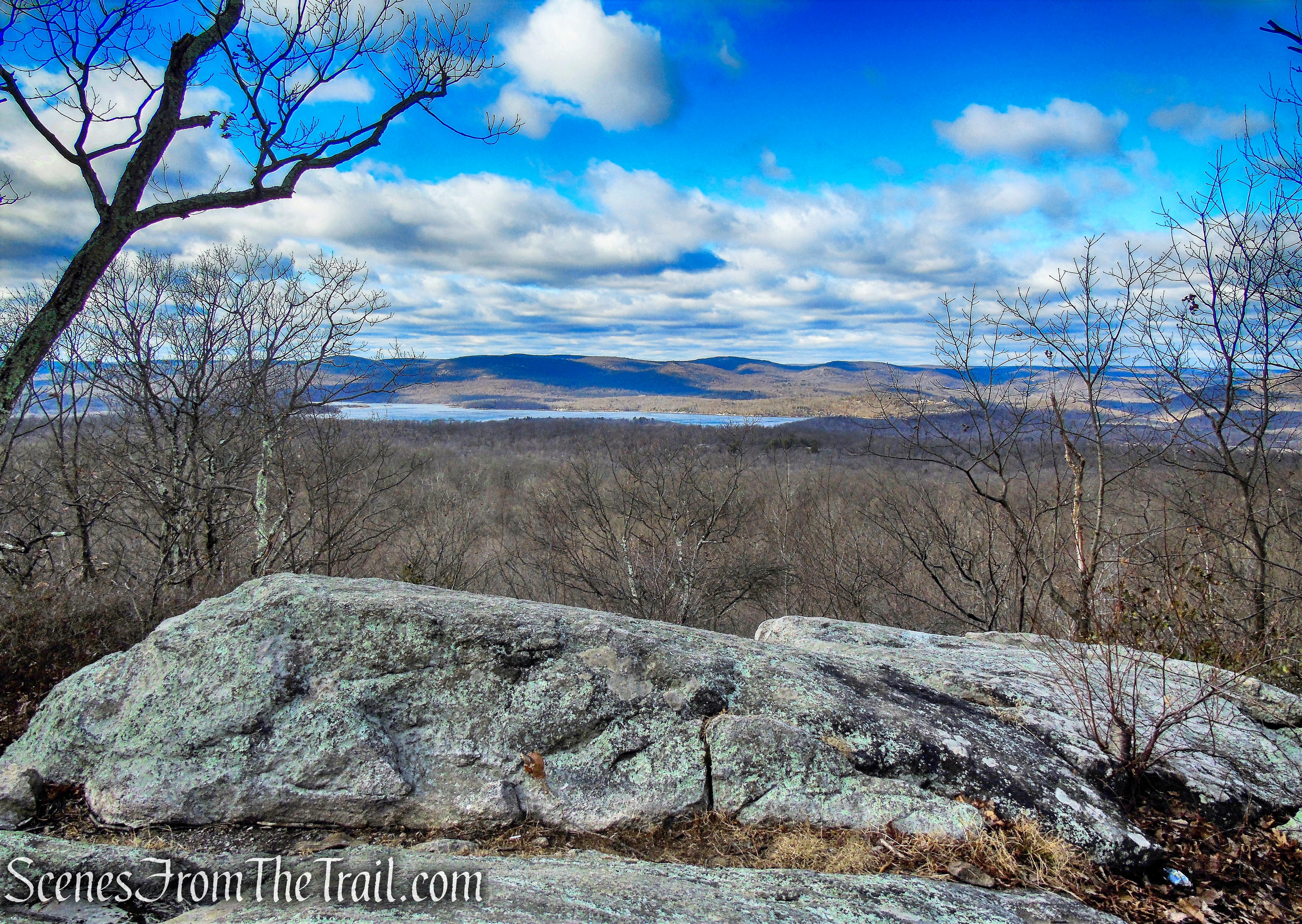
Cross to the east side of Skyline Drive, where a triple-white blaze on a telephone pole opposite the parking area marks the start of the Todd Trail. Follow this white-blazed trail as it winds downhill on a rocky footpath and then ascends from a shallow ravine. In half a mile, the trail turns right onto a woods road. Follow the white blazes as they bear left onto another woods road, soon passing the trailhead for the Yellow Trail on the left, and then turn right into the woods. The Todd Trail ascends to a grassy knoll, which affords a panoramic view over Oakland (on the left), with Crystal Lake in the foreground.

Skyline Drive

Todd Trail

Todd Trail

Todd Trail

Todd Trail
Todd Trail

Todd Trail
Todd Trail

Todd Trail

Todd Trail

NYC view – Todd Trail
From the viewpoint, the trail turns sharply right, makes a short, steep descent and follows along the side of a hill. After descending and crossing an old paved road, the trail turns left onto a woods road. Continue to follow the white blazes as the trail passes several intersecting woods roads, then turns left, leaving the road, and climbs to cross Skyline Drive, a mile and a half from the start of the hike.
Todd Trail

Todd Trail

Todd Trail

Todd Trail

Todd Trail
On the other side of Skyline Drive, the Todd Trail crosses a wooden footbridge and ascends a knoll, then descends through a mountain-laurel thicket. After a level stretch, the Todd Trail ends at a junction with the blue-blazed MacEvoy Trail. Turn right, cross a stream, and follow the blue blazes along a wide woods road towards Ramapo Lake. Soon, the yellow-blazed Hoeferlin Memorial Trail joins from the right. Continue ahead, now following both blue and yellow blazes.

Todd Trail

Todd Trail

Todd Trail

Todd Trail

Todd Trail

stream crossing – MacEvoy Trail
MacEvoy Trail

MacEvoy Trail
Soon, the trail bears left and descends a short pitch to the dam of Ramapo Lake (just to the left). Here, the yellow-blazed Hoeferlin Memorial Trail turns left, crossing the dam, but you should continue ahead onto North Shore Drive, following the blue blazes of the MacEvoy Trail. The MacEvoy Trail follows a gravel road along the northeast shore of the lake, passing a private home on the right and then crossing a small stream on a stone-arch bridge, with an attractive cascade to the right.

turn right on MacEvoy Trail

Ramapo Lake

Ramapo Lake Natural Area
Ramapo Lake
MacEvoy Trail

MacEvoy Trail
A short distance beyond, you’ll come to a rock ledge on the left that overlooks the lake. This is a good place to take a break. Once known as Rotten Pond, and later as Lake LeGrande, Ramapo Lake is the centerpiece of Ramapo Mountain State Forest. It was formerly surrounded by private property, but most of the land around the lake was acquired by the state in the 1970’s.

Ramapo Lake
Ramapo Lake

abandoned stone building – Ramapo Lake
Just beyond, the trail reaches the northern tip of Ramapo Lake. Here, a triple-white blaze marks the start of the Castle Point Trail. Bear right at the fork in the road, now following both white and blue blazes, and pass between two concrete pillars. A short distance ahead, the blue-blazed MacEvoy Trail leaves to the left, but you should continue ahead on the road, now following only the white blazes of the Castle Point Trail. Just beyond, as the road curves sharply to the right, turn left, leaving the road, and follow the white-blazed trail as it climbs steadily and rather steeply.

Bear right at the fork in the road

Castle Point Trail

Castle Point Trail

Castle Point Trail

Castle Point Trail

Castle Point Trail

Castle Point Trail
Castle Point Trail

Castle Point Trail
As you approach the top of the climb, bear left onto a rock ledge that offers a spectacular view. Directly below you is Ramapo Lake, with the Wanaque Reservoir to the right (west). On a clear day, you can see the New York City skyline on the horizon to the left. You’ll want to pause here to rest from the steep climb and enjoy the view.
view of Ramapo Lake

NYC view from Castle Point Trail
When you’re ready to continue, follow the white trail uphill. After climbing over a stone wall on a step-stile, you’ll reach the ruins of a mansion. Known as Foxcroft, it was built around 1910 by William Porter, a stockbroker. His widow occupied it until her death in 1940, and it fell into ruin in the late 1950’s. Use caution if you wish to explore the remains of this once-elegant stone structure.
Castle Point Trail

Van Slyke Castle

Van Slyke Castle

Van Slyke Castle

Van Slyke Castle
Van Slyke Castle

Van Slyke Castle

Van Slyke Castle
Van Slyke Castle

Van Slyke Castle

Van Slyke Castle
The trail continues to the north, passing the remains of a concrete swimming pool. Just beyond, the trail bears left and soon reaches an unobstructed west-facing viewpoint over the Wanaque Reservoir and the Wyanokie Mountains.

pool – Castle Point Trail
pool – Castle Point Trail
view west – Castle Point Trail
Continue on the white trail, which climbs to a stone tower. Contrary to what one might think at first glance, this was not a lookout tower; rather, it held a cistern that supplied water to the mansion (note the rusted pipes adjacent to the tower). Just beyond, there is another view from an open rock ledge to the left of the trail over the Wanaque Reservoir to the west. The trail now begins to descend.

Castle Point Trail
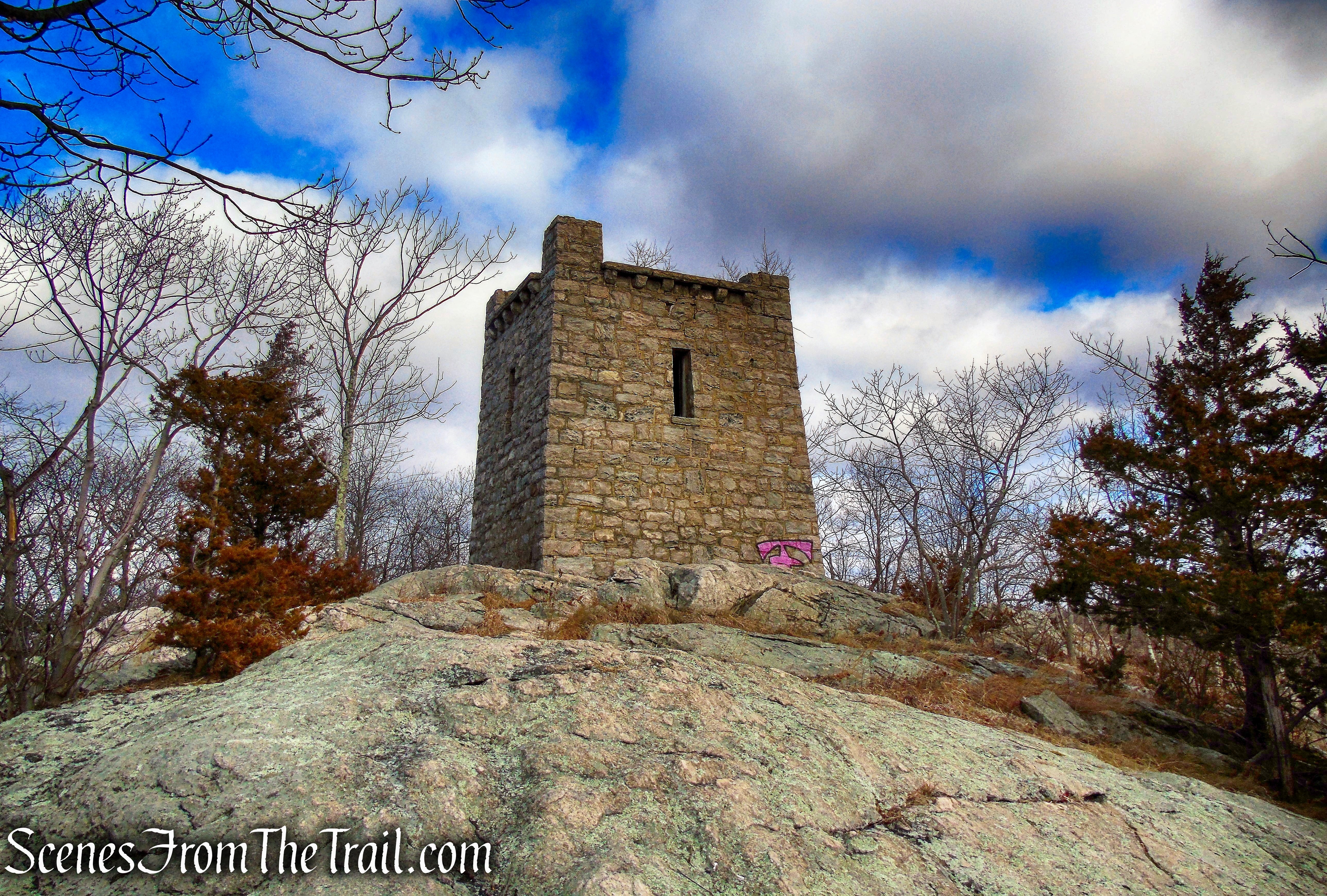
cistern – Castle Point Trail

cistern – Castle Point Trail

view west – Castle Point Trail

Castle Point Trail

Castle Point Trail
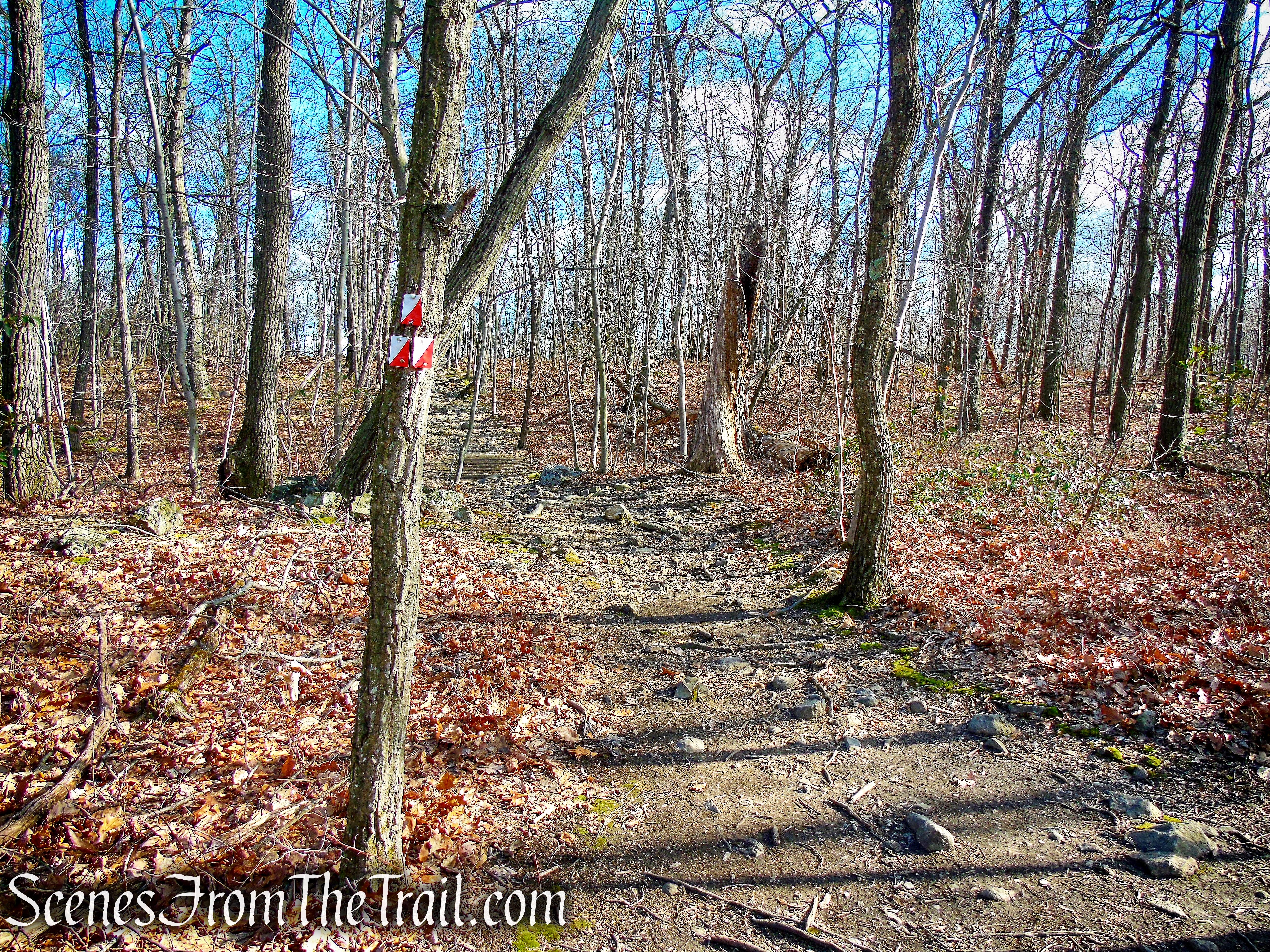
Watch carefully as the Castle Point Trail briefly turns left onto a woods road, then immediately turns right before reaching the route of a gas pipeline. It turns right again onto a woods road, turns left onto a footpath before reaching a wide gravel road, then turns right and follows the gas pipeline for 350 feet. After turning right and leaving the pipeline, the trail crosses a stream and climbs, first gradually, then rather steeply through mountain laurel, to a rock ledge with a broad view. From the ledge, you may be able to see the stone tower you passed about half a mile back.

Castle Point Trail

Castle Point Trail

Castle Point Trail

Castle Point Trail

Castle Point Trail
A short distance beyond, the Castle Point Trail reaches a paved road, with Skyline Drive just to the left. Here, the Castle Point Trail ends, and you turn right to continue along the Cannonball Trail (white-“C”-on-red blazes). The trail follows the road for 200 feet, then turns left onto a footpath through the woods. Soon, you’ll reach a junction where the red/white-blazed Skyline Connector Trail begins on the left. Turn left and follow this red/white trail along a footpath roughly parallel to Skyline Drive until you reach the parking area where the hike began.

terminus of Castle Point Trail

Cannonball Trail

Cannonball Trail
Skyline Connector Trail

Skyline Connector Trail

terminus of Skyline Connector Trail

Upper Parking Lot Trailhead
Review:
The highlight of this hike is the Van Slyke Castle ruins, but the trails are enjoyable as well. Slightly challenging, but doable by the average hiker. On a cold windy day, the trails were mostly deserted except for the area around the lake and at the castle ruins. The first view on the Todd Trail and the last view on the Castle Point Trail are not that impressive, but the other views are quite nice. There are several stream crossings on this hike that are fun and in times of high water, could be a little challenging. Overall, a very good hike that I would recommend.
Although the trails are well marked, there are a significant amount of blazes painted on rock slabs in areas that are devoid of trees. This may cause a problem when there is snow cover.
Pros:
Van Slyke Castle ruins, Ramapo Lake, scenic views, scenic landscape, well blazed trails.
Cons:
Crossing Skyline Drive.
Take a hike!

Van Slyke Castle Loop – Ramapo Mountain State Forest
Sources:

Is Foxcroft the same as the Van Slyke Castle? The pictures all seem to say “Van Slyke Castle”. I used to hike up there from the lake (and over to the cleared space for the power or pipe lines and down the road/driveway) in the early ’80s. I only remember the one ruined mansion with the pools and tower, and heard that it had burned in the late ’50s and early ’60s while the [MacEvoy] family was in Europe That, of course, could very well be a conflation of several events (I heard a conflated story that contained different pieces of events over 400 years from a booth attendant at Dunboy Castle in Ireland once). A ranger who was coming down the trail when I was going up circa 1983 warned me to stay out of the foundation because there were copperheads in it.
LikeLike
Yes, Van Slyke Castle and Foxcroft Mansion are one and the same. Read the “History” section of this post which explains the name change.
LikeLike