July 15, 2017 – Southfields, NY
Difficulty: Moderate
Length: Approximately 7 miles
Max elevation: 1,260 ft.– total elevation gain approximately 769 ft.
Route type: Circuit
Map: Harriman-Bear Mountain Trails Map 118
Trailhead parking: 1184-1340 Kanawauke Rd, Southfields, NY 10975
At 310 acres, Lake Sebago is the largest lake in Harriman State Park. The name is Algonquian for “big water.” The lake was created in 1925 by the Palisades Interstate Park Commission under William A. Welch by building a dam across Stony Brook. The lake filled the former site of Johnsontown, a pre-revolutionary logging settlement founded in the mid-1700’s in the Stony Brook valley. By the early 1900’s, Johnsontown was the largest mountain settlement in the western part of the Ramapos. In 1916-17, the PIP condemned the land, on the grounds that the settlement was built on swampland (“the great Emmetfield Swamp”). Many homeowner’s resettled in nearby Sloatsburg. The PIP took possession of the land and the homes, stores, school and church were torn down before the Stony Brook valley was flooded to create the new lake. Remnants of the Johnsontown sawmill is still visible to scuba divers.
In 1931, a beach area was constructed on the southeastern side of the lake. Two rustic buildings were erected, and 70 concrete tables and benches were installed. That “Old Sebago Beach” served until 1952 when “New Sebago Beach” was opened at the north end of the lake, where Johnsontown had once stood. Damage caused by Hurricane Irene in 2011 closed the beach indefinitely and from the looks of it today, it doesn’t appear as it will ever be reopened. Left in a state of abandonment, it has begun to be reclaimed by nature.
I faintly recall visiting Sebago Beach as a child on those hot summer days when we would load up the car and cross the Tappan Zee Bridge to go swimming and grilling. Lake Welch was our destination of choice back then, but I do recall several excursions to “New Sebago Beach.” I decided to map out a hike to Sebago Beach and loop around the western shore of Lake Skenonto. I also included the Tom Jones Shelter as it was not too far from the designated route and to also add some mountain views. The hike was done clockwise from County Road 106 (the top of the map), visiting Tom Jones Shelter, Lake Sebago Beach then passing Lake Skenonto on our return.

hike route
A new feature that I have added is the Google Earth Fly-Through. It follows the path that we hiked and it gives you a good idea of the terrain, layout, amount of parking etc. Check it out, it’s pretty cool.
View the Google Earth Fly-Through video of the hike below.
A fair amount of rain fell from Friday night into Saturday morning, but the forecast was promising. With all that rain, I knew that the trails would be muddy and the rocks slick in the early morning hours, but we had to get out to the trails early due to limited roadside parking at the trailhead. We were the first car in the area where we parked, but upon our return at approximately 4:00 pm, every available space was taken. We crossed the road and walked east for about 350 feet to the beginning of the blue-V-on white blazed Victory Trail.
Victory Trail
This section of the Victory Trail was blazed in 1949, the trail was extended from the fireplace at the foot of Tom Jones Mountain out to Route 210 (now Route 106). This section of the trail travels the notch between Parker Cabin and Tom Jones Mountains.
Victory Trail
The trail was a little swampy at the outset, but considering all the rain just hours earlier, it wasn’t too bad.
Victory Trail
We were able to circumvent the swampy area at times and at others just walked right through them as we headed southeast on the Victory Trail.
Victory Trail
In about 1/3 of a mile, we came to a junction with the red-dot-on-white blazed Ramapo-Dunderberg (R-D) Trail. To the right, the R-D Trail goes up to Parker Cabin Mountain. We turned left and headed towards Tom Jones Shelter.
junction with the Ramapo-Dunderberg Trail
The Ramapo-Dunderberg Trail (R-D) was the first trail in Harriman State Park to be built and is just over 23 miles long. Here the trail climbs the western slope of Tom Jones Mountain on rocks.
Ramapo-Dunderberg Trail
The mountain was named after one of the members of the Claudius Smith gang. The R-D Trail climbs rather steeply at first then levels off somewhat.
Ramapo-Dunderberg Trail
The R-D Trail then resumes its steep climb over rocks as it nears the top.
Ramapo-Dunderberg Trail
The R-D trail then climbs more moderately. I saw an unmarked side trail that went to the right and seemed to wrap around the the side of a rock formation, but I ignored it and kept going up the R-D Trail onto open rocks. I saw a hiker approaching from the opposite direction and asked him if he knew where the Tom Jones Shelter was. He indicated that is was just below us. So that side trail that I ignored probably led right to it. Nevertheless, we descended down the side of some rock formations and we were there.
Tom Jones Shelter
The Tom Jones Shelter, built in 1927, was the first trail shelter built in Harriman State Park. The plans were drawn by Major Welch and built by John Tamsen, supervisor of construction, along with some old timers that were handy with rocks and logs. It is eighteen feet long, fourteen feet deep and nine feet high at the pitch of the roof. It also has two fireplaces with chimneys.
Tom Jones Shelter
This was a nice place for a break to enjoy a nice view of the Harriman hills and Lake Sebago in the distance.
view from Tom Jones Shelter
Knowing we had to make our way back to the Victory Trail in order to head towards Lake Sebago, I made an executive decision to bushwack south and meet up with the Victory Trail further down rather than retrace our steps back on the R-D Trail and have to tackle a steep descent on wet rocks. At first we descended on a footpath which I thought might lead us down where we wanted to go.
unmarked path
The path led to a rock outcrop and several campsites, but also provided a gorgeous view of Lake Sebago and the surrounding hills.
view of Lake Sebago and surrounding hills
The unmarked trail seemed to lead north so we walked around the west side of the rock outcrop and descended a somewhat steep rocky slope.
steep rocky slope
The hike down the rocky slope was short lived and wasn’t too difficult, but it knocked off the mileage we would have gained if we had back tracked. The image below is looking up from the base of the descent.
base of the descent
This turned out to be a good shortcut as the rest of the way to the Victory Trail was a gradual descent through the tree lined forest.
tree lined forest
On this hike we encountered many cave-like openings that were big enough for a family of bears. I love the geological features of Harriman and I am always wowed by its beauty. On many of the hikes that I do here, It’s like passing through areas that time forgot.
cave
The Victory Trail is fairly level in this area, with some gentle ups and downs. We encountered quite a few stream crossings on this hike. That may be due to all the recent rain, but I always find them fun.
Victory Trail – stream crossing
The Victory Trail comes to a junction with a paved park road and turns right.
Victory Trail
A short distance later, we came to a fork in the road, veered left and bid adieu to the Victory Trail……for now.
veering left at the fork in the road
The park road passes by several corrugated metal buildings that lay in ruins.
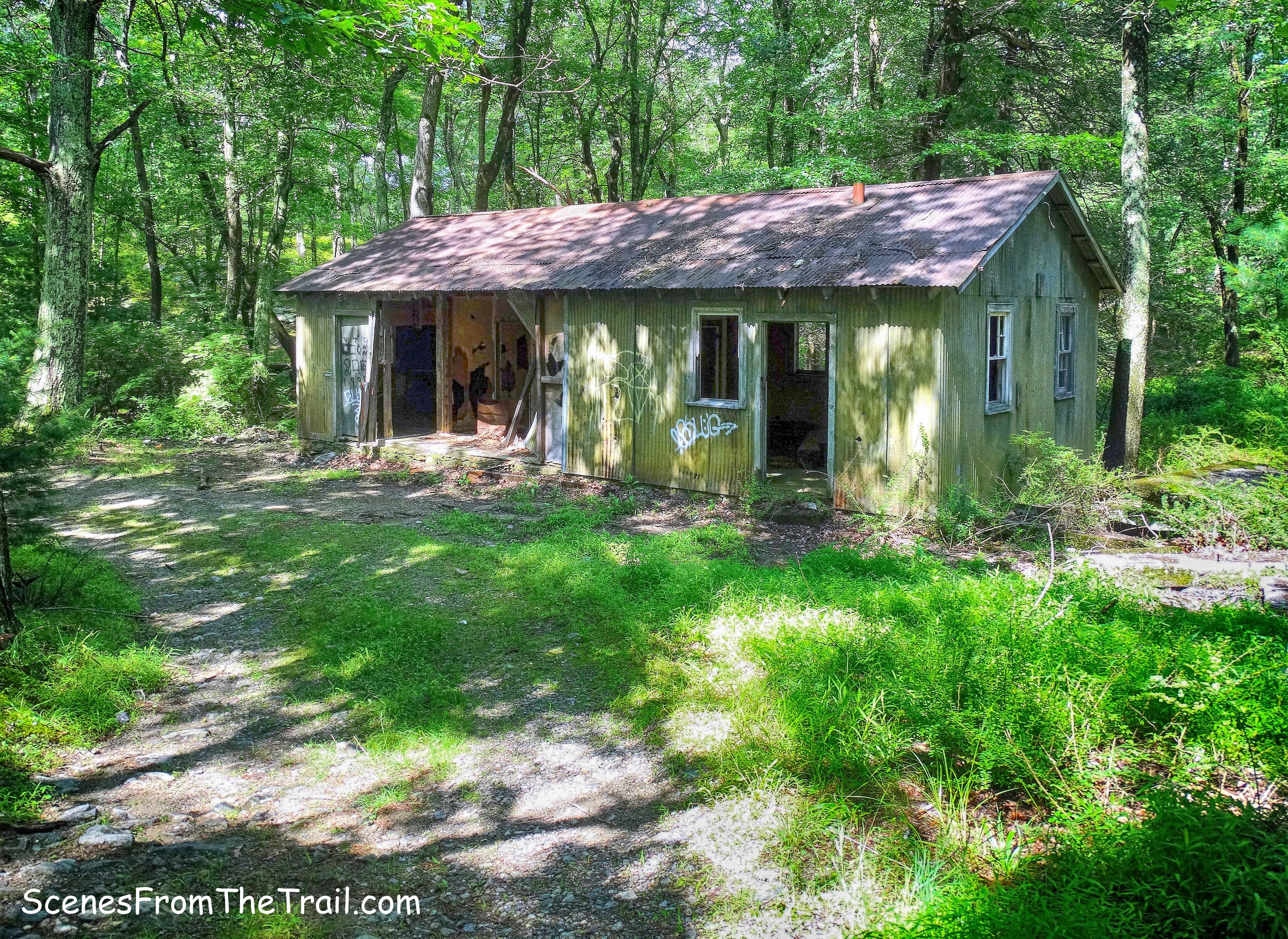
corrugated metal building
Shortly after passing the metal buildings we arrived at the northwestern shore of Lake Sebago. The first thing we saw was the building that housed the restrooms for the picnic area.
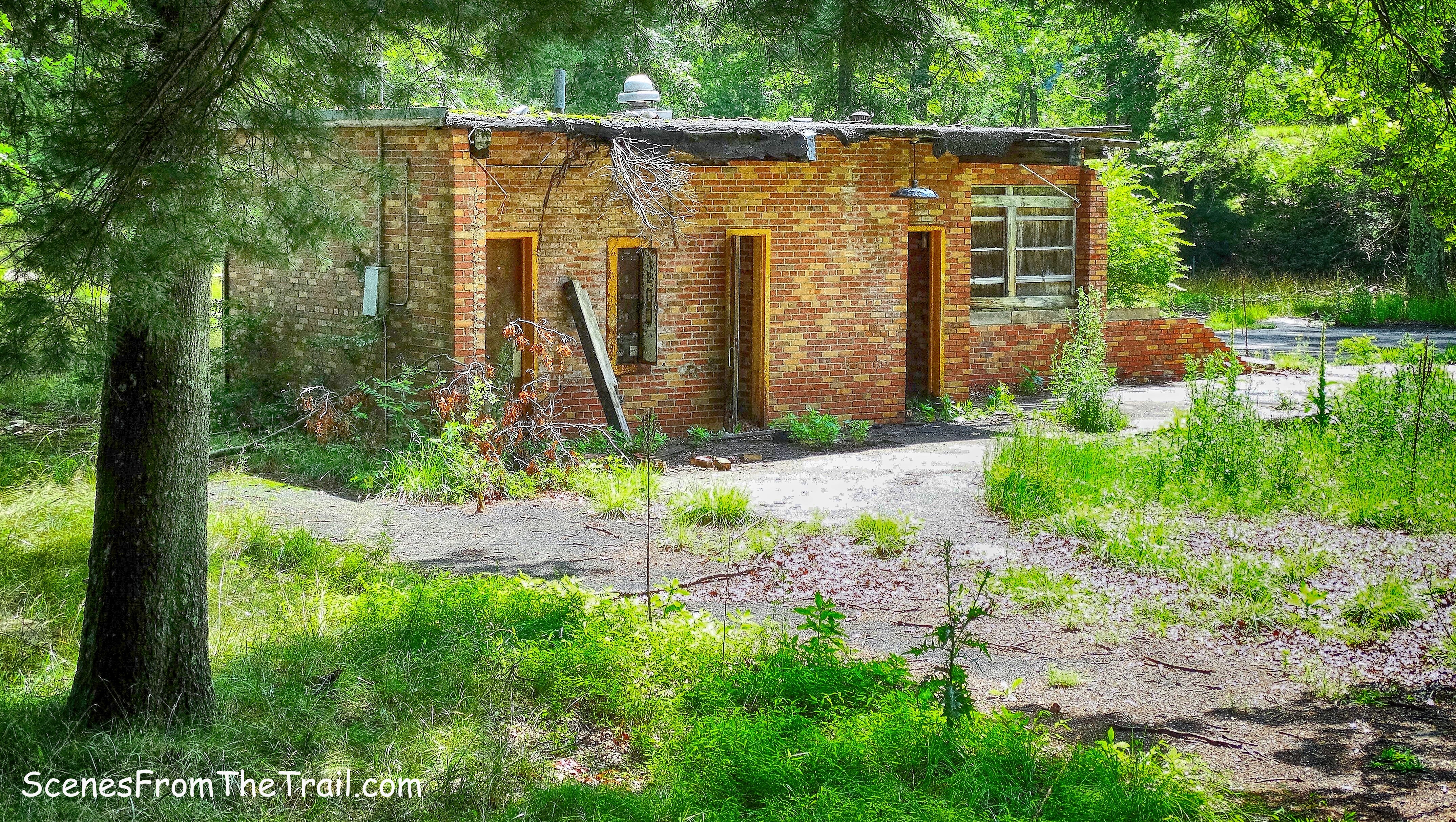
restrooms
We then headed for the shore of the lake, passing a stone building on the way.
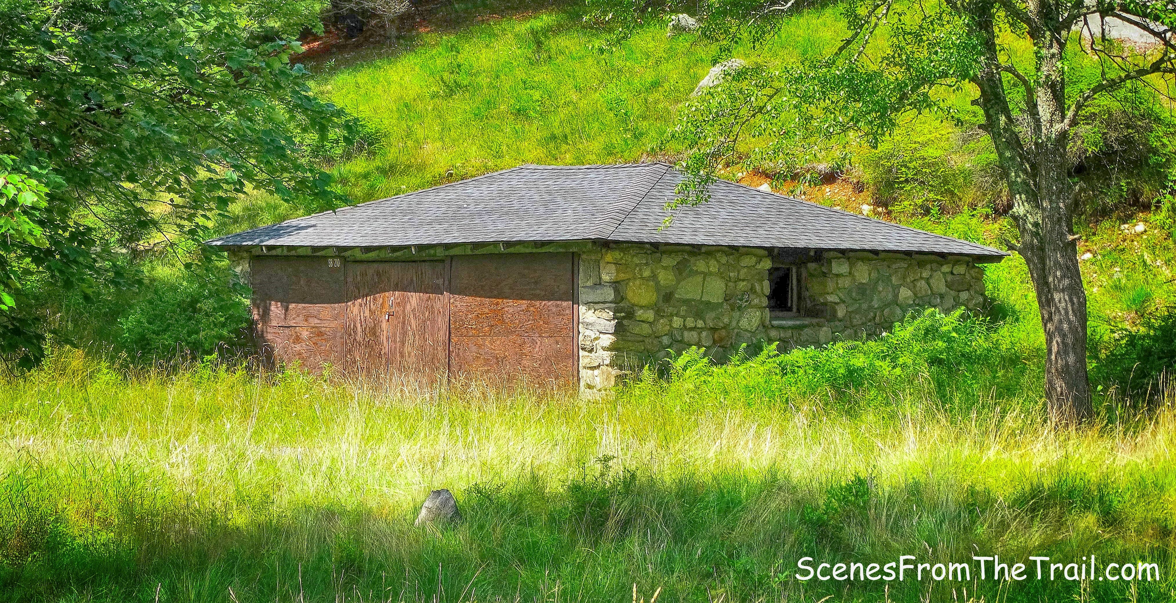
stone building
We got to the shore of Lake Sebago and it was quite a sight. Not a soul around and the view wasn’t bad either.
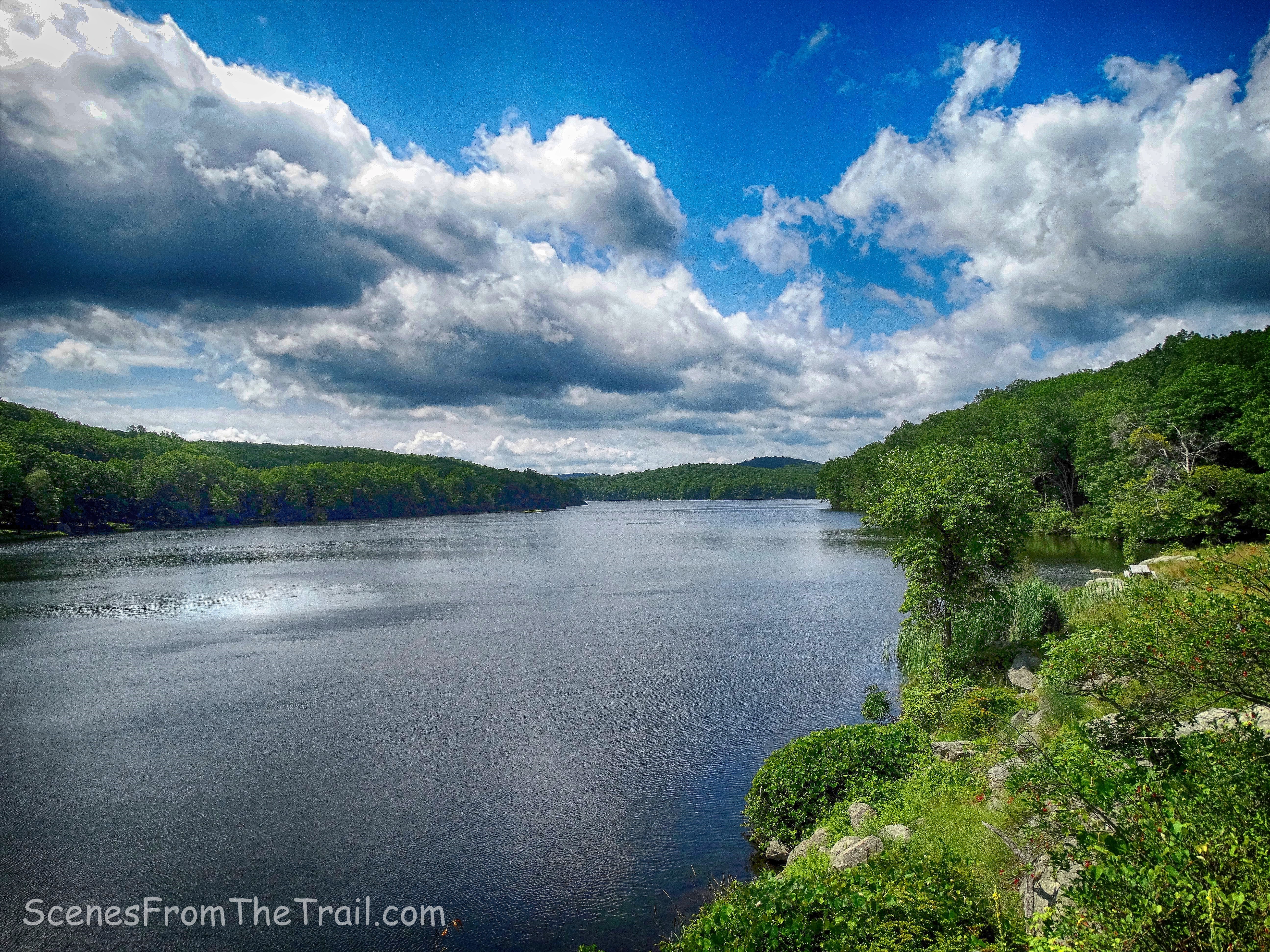
Lake Sebago looking south
Looking north towards the beach, our next stop, the view was just as splendid.
Lake Sebago looking north
A closeup shows what was once a sandy beach, now heavily eroded and filled with weeds. The buildings now fallen into disrepair.
Lake Sebago Beach
We walked along the crumbling road and walkway to the once bustling promenade. The benches that overlook the beach, now swallowed by nature.
promenade
What was once a soft sandy beach crowded with sun worshipers, beach chairs and umbrellas is now filled with rocks and weeds.
Lake Sebago Beach
The long tree lined walkway from the parking lot to the beach brought back memories. Back then, when I was a kid, it seemed like it took forever to get to the sand from the vehicle.
tree lined walkway
The beach was eerily quiet while we were there. Not even the birds made a sound. With the exception of a few Turkey Vultures hovering up above, there were no signs of life in the area, with the exception of us of course. It is still a scenic place to visit even though it seems to have been forgotten by those that oversaw it.
picnic table
We relaxed there for quite some time then headed back to northwestern side of the lake, and walked up a hill that overlooks the lake that leads to a picnic area. While walking and taking photographs, I almost stepped on this Rat Snake that was hiding in the tall grass.

Rat Snake
We passed an old picnic shelter that in its heyday was probably a well sought-after spot.
picnic shelter
We then walked down a short gravel road and turned left. Now heading south along the western shore of Lake Sebago on the unmarked Sloatsburg Trail that mostly hugs the shoreline. The trail is faint at first, but then becomes more discernable.
unmarked Sloatsburg Trail
Before the lake was made in 1925, the Sloatsburg Trail was a road along the edge of Emmetsfield Swamp. The old road here has now been covered by the lake, so the present-day trail is a relatively level footpath which parallels the old road.
Myles, William J.. Harriman Trails: A Guide and History (Kindle Locations 4718-4720). New York – New Jersey Trail Conference. Kindle Edition.
unmarked Sloatsburg Trail
This was my favorite trail on this hike. It is almost entirely level, with the hillside to the right and Harriman’s gorgeous rock formations dotting the landscape.
rock formation
At times the trail follows the very edge of the shoreline……
Sloatsburg Trail
which provides splendiferous views of the lake.
Lake Sebago looking northeast from the Sloatsburg Trail
We came to a stream that flows from Lake Skenonto to Lake Sebago. This proved to be the most difficult stream crossing of the hike. It was wider and deeper than the others, but manageable nonetheless.
stream crossing on the Sloatsburg Trail
A short distance later we came to a junction with the yellow-blazed Triangle Trail. We turned right on the Triangle Trail, now heading northwest, which begins a gradual ascent.
Triangle Trail
The Triangle Trail was first marked in 1939 as the Yellow Bar Trail, with yellow bands around the trees, using already existing roads and trails. Early in 1942, the Trail Conference marked a Yellow Triangle Trail from Parker Cabin Mountain to the arm of Lake Sebago and continuing to ADK Camp Nawakwa.
Triangle Trail
The Triangle Trail skirts a swamp at the southern end of Lake Skenonto with a view from open rocks.
view from Triangle Trail
The Triangle Trail curves towards the western shore of Lake Skenonto and then briefly joins the Victory Trail which comes in from the left. The Triangle Trail then turns left, but we stayed on the Victory Trail which parallels the western shore of Lake Skenonto. There are numerous spur trails that lead to viewpoints over the lake. After Lake Sebago was finished in 1926, there was still a “Big Swamp” just over the hill on the western side. This swamp became Lake Skenonto.
Lake Skenonto
The dam was built in 1934 and the lake was filled with water by 1936. Looking east, the dam is visible in the distance.
Lake Skenonto
We began to follow a trail at the edge of the lake that quickly fizzled out. We then bushwacked west back to the Victory Trail which is now a woods road.
Victory Trail
Along this trail, we encountered numerous groups of people that were heading to or from the lake. It’s such a beautiful spot and located near several trails which makes it relatively easy to get to.
view from the northern shore of Lake Skenonto
We continued to follow the Victory Trail west. It goes from woods road…..
Victory Trail
to a paved road……
Victory Trail
to a footpath.
Victory Trail
A few more stream crossings and we made our way back to County Road 106 and the parking area where our hike began. We were pretty tired at this point and even though the hike was not strenuous by any means, the length of it wore us down. I truly enjoyed the hike and would recommend it to others. I hope that you enjoyed the hike and please don’t forget to follow my blog. Now get out there and take a hike!
Pros: Tom Jones Shelter, Lake Sebago, Lake Skenonto, scenic views, rock formations, woods roads, abandoned beach, ruins, lesser traveled trails.
Cons: Crowds near Lake Skenonto.
Take a hike!

another beauty ! such great documentation of the trail – thanks for a great idea !
LikeLiked by 1 person
Thanks for reading, but you really should be hiking, LOL.
LikeLike