June 12, 2022 – Pawling, NY
Difficulty: Moderate
Length: Approximately 2.3 miles
Max elevation: 1171 ft. – total elevation gain approximately 683 ft.
Route type: Out-and-back
Map: Appalachian Trail Map – Dutchess County
Free Avenza App Map: Appalachian Trail – Dutchess & Putnam Counties, NY
Trailhead parking: West Dover Road, Pawling, NY 12564
No toilets on site – No entrance or parking fees
Pull-off parking on shoulder for about 10-12 cars
Overview:
Cat Rocks is an eastern facing rock outcrop on West Mountain in Pawling, NY about 1,171 feet above sea level. It provides a birds’ eye view of the Harlem Valley, Litchfield County, Connecticut and beyond.

Cat Rocks – Pawling, NY
The Harlem Valley comprises the towns and hamlets of Pawling, Wingdale, Dover Plains, Wassaic, Millerton, Millbrook, and Beekman. The valley is part of the 2,190-mile-long Appalachian Mountain landscape known as the Wild East. Only an hour train ride from New York City, visitors can explore 16 miles of the A.T. through Dover and Pawling, with hikes ranging in ability from easy rolling terrain to rock scrambles.
Dover and Pawling were designated as an A.T. Community in 2013, known collectively as the Harlem Valley A.T. Community (HVATC).
History:
In 1921, Forester, conservationist and regional planner Benton MacKaye proposed a hiking trail from Georgia to Maine, primarily through the Appalachian and Berkshire mountains, envisioning the Trail as a utopian refuge from urban life. Less than two years later, work began on the great trail, with the first completed section being the stretch from Bear Mountain to its present-day crossing with I-87. It was fully finished in 1937, and though it’s been tweaked in the decades since, it’s essentially the same trek that was envisioned by MacKaye himself.
What began as a vision of Benton MacKaye, was developed by volunteers, and opened as a continuous trail in 1937. It was designated as the first National Scenic Trail by the National Trails System Act of 1968. The Trail is currently protected along more than 99 percent of its course by federal or state ownership of the land or by rights-of-way. Annually, more than 4,000 volunteers contribute more than 185,000 hours of effort on the Appalachian Trail.
Spanning 14 states, from Springer Mountain, Georgia to Mount Katahdin, Maine, the 2,190 mile-plus hiking trail is the longest hiking-only trail in the world. More than three million people hike segments of the trail each year.
Trails Overview:
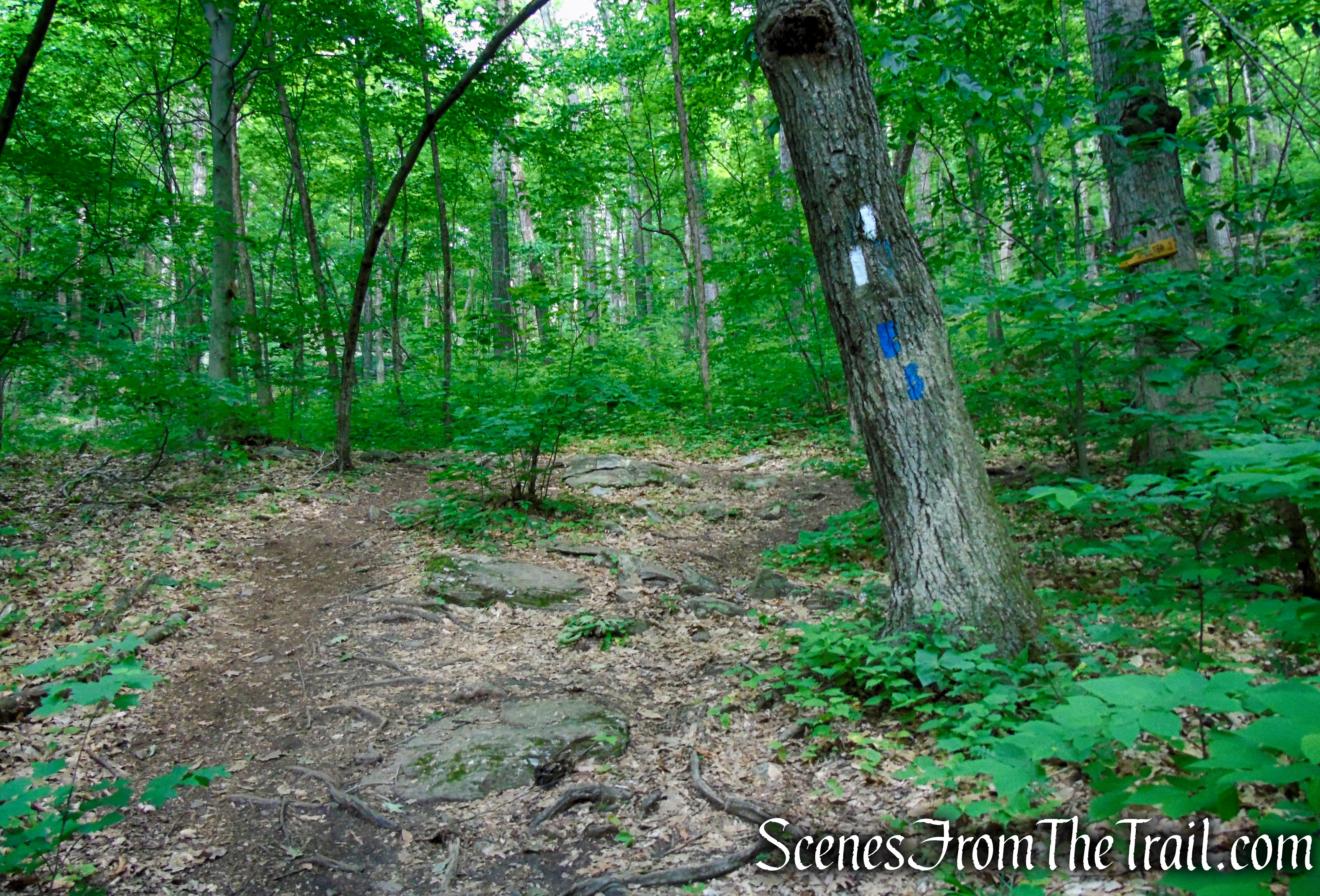
Throughout its entire length, the AT is marked by white paint blazes that are 2 by 6 inches. Side trails to shelters, viewpoints and parking areas use similarly shaped blue blazes. The Appalachian Trail “AT” Logo is the “A” with the dropdown “T.”

Appalachian Trail – Pawling, NY
The trail is well marked in this section with many fresh white blazes. A brief rock scramble near the beginning can be bypassed via an unmarked footpath to the left, at the base of the steep section.
There is a short section near West Dover Road that is a little overgrown. Near Cat Rocks, where the trail levels off, the underbrush overlaps the narrow footpath. Long pants or some kind of tick repellant is recommended.
Hike Overview:
Cat Rocks in Pawling, the subject of this hike, is not to be confused with Cat Rocks in Warwick, NY. They are both on the Appalachian Trail in NY, but in different towns and counties.
With threats of thunder storms in the forecast, I was looking for a shorter hike than previously planned. The hike to Cat Rocks fit the bill perfectly. There is pull-off parking along the shoulder of West Dover Road (County Route 20), right by the Dover Oak.
Please note: The Appalachian Trail crosses West Dover Road right where the Dover Oak is, but the hike begins on the opposite side of the road from the massive oak tree.
On the day of this hike, we only encountered a handful of people, including two thru-hikers. It was very quiet along the trail with only the sound of birds and the occasional roar of a Harley rolling by on West Dover Road.
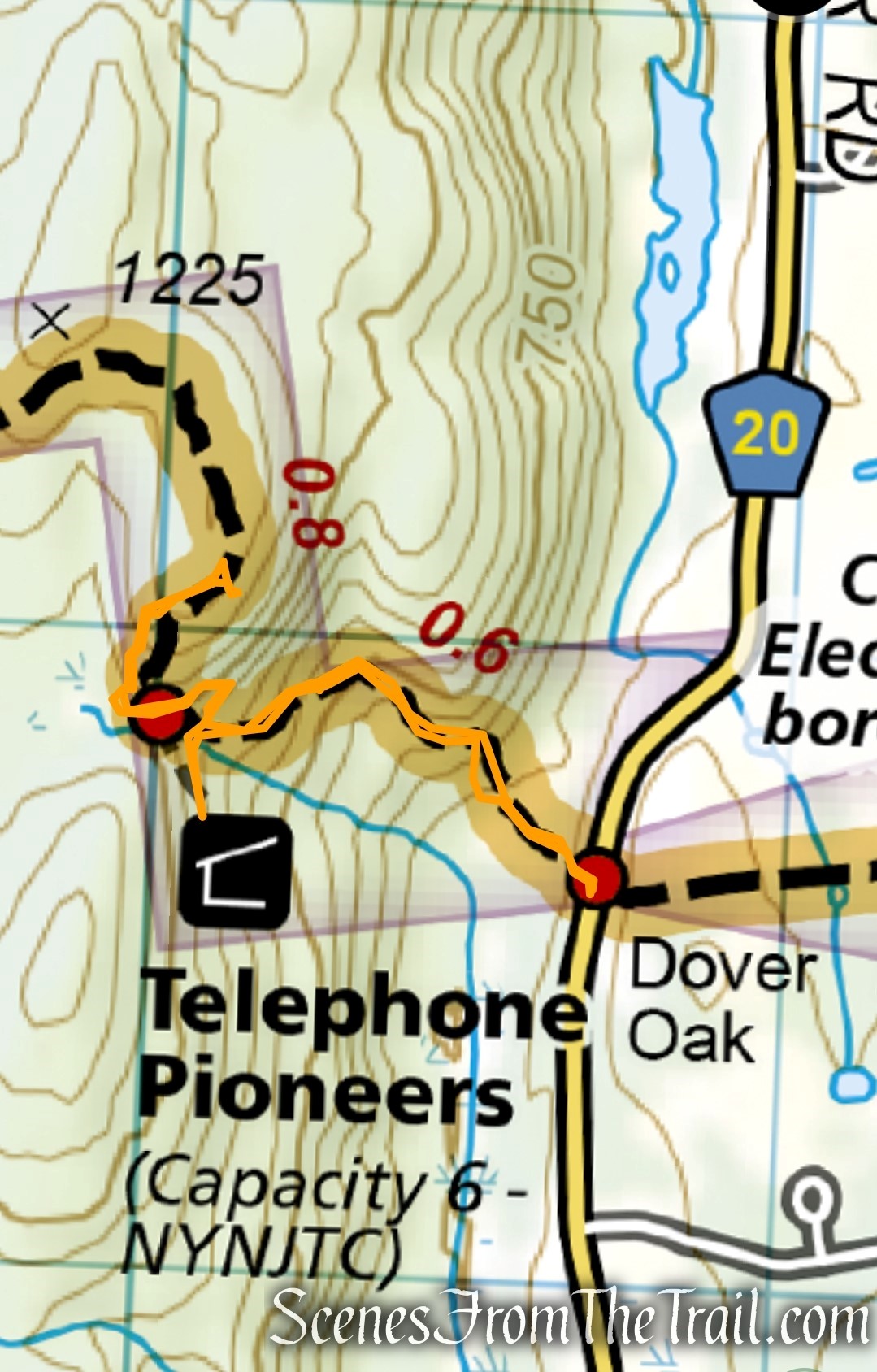
This hike is a simple out and back with a stop at the Telephone Pioneers Shelter on the way down.
Dover Oak to Cat Rocks
The majority of the elevation gain is in the first mile on the way to Cat Rocks.
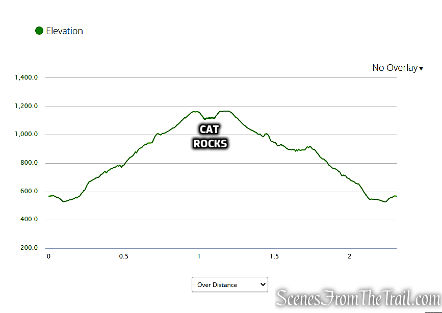
elevation profile – Cat Rocks
The Hike:
The Appalachian Trail crosses the road right at the Dover Oak. This white oak, estimated to be about 300 years old, has a circumference of over 20 feet, and is believed to be the largest blazed tree along the entire AT from Maine to Georgia.

Dover Oak – Pawling, NY
On the other side of the road from the Dover Oak, the trail descends to cross a wet area on rocks and puncheons. A short distance beyond, the trail climbs a jagged rock formation and begins its steady ascent of West Mountain, crossing a stream on a wooden bridge along the way.

Appalachian Trail – Pawling, NY

Appalachian Trail – Pawling, NY

Appalachian Trail – Pawling, NY

Appalachian Trail – Pawling, NY

Appalachian Trail – Pawling, NY

Appalachian Trail – Pawling, NY

Appalachian Trail – Pawling, NY

Appalachian Trail – Pawling, NY

Appalachian Trail – Pawling, NY

Appalachian Trail – Pawling, NY

Appalachian Trail – Pawling, NY

Appalachian Trail – Pawling, NY

Appalachian Trail – Pawling, NY
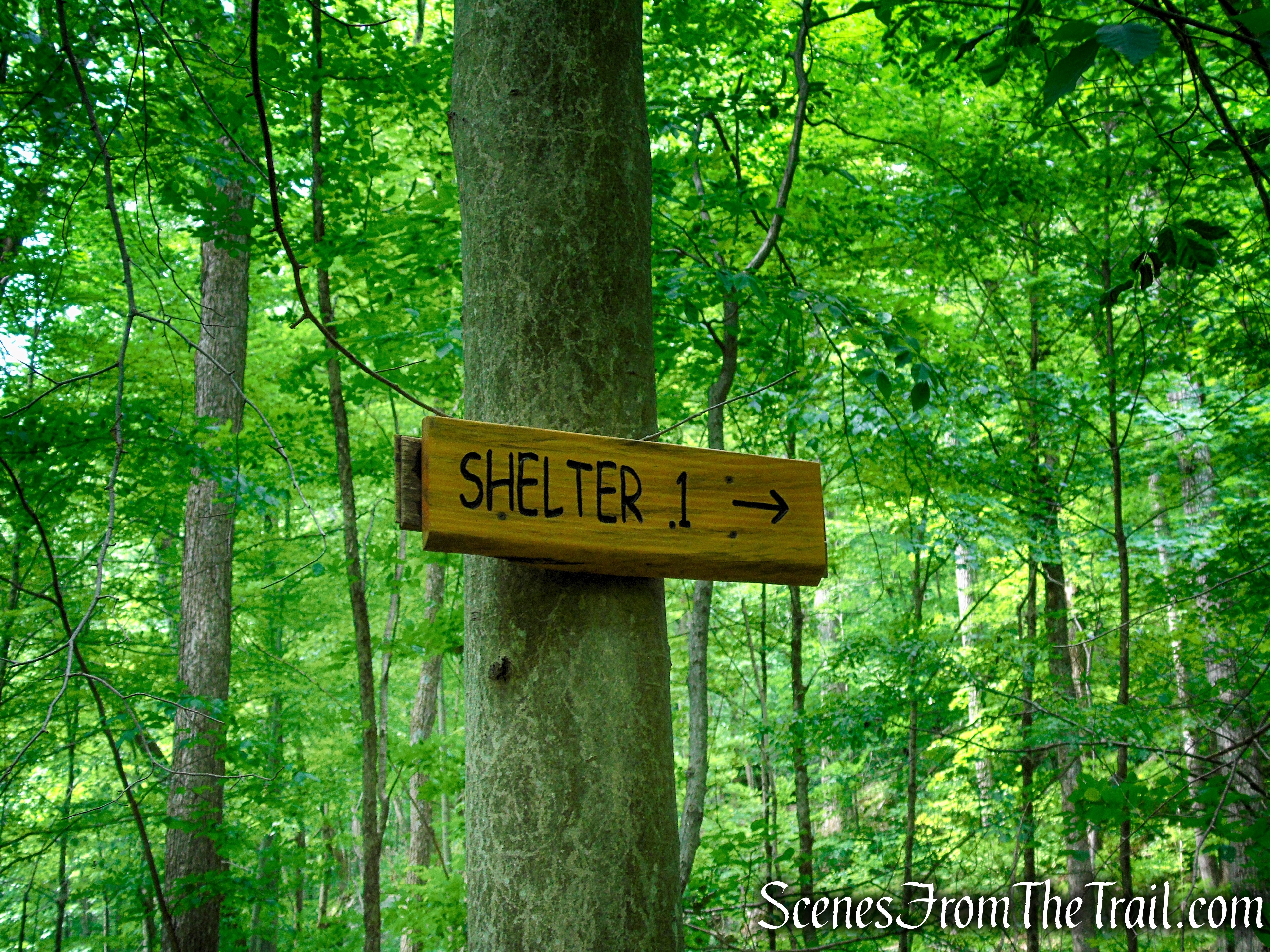
After climbing for about half a mile, you’ll come to a junction on the left, where a blue-blazed side trail leads to the Telephone Pioneers Shelter. Bear right at the intersection and continue following the white blazes of the AT.

Appalachian Trail – Pawling, NY

Appalachian Trail – Pawling, NY

Appalachian Trail – Pawling, NY
turn right on Appalachian Trail

turn right on Appalachian Trail
The AT climbs some more, turning left at an interesting looking mass of rock. A short distance later, the trail approaches the grass-covered summit ridge of West Mountain. Just below the summit, a side trail on the right leads a short distance to Cat Rocks – a panoramic east-facing viewpoint from an open rock outcrop. Down below, you can see West Dover Road, with fields beyond.

Appalachian Trail – Pawling, NY

Appalachian Trail – Pawling, NY

Appalachian Trail – Pawling, NY

Appalachian Trail – Pawling, NY

Appalachian Trail – Pawling, NY

Appalachian Trail – Pawling, NY

turn right on unmarked footpath

Cat Rocks – Pawling, NY

Cat Rocks – Pawling, NY
Please exercise caution on this slanted rock outcrop, especially if the ground is wet. In May 2021 a hiker fell more than 50 feet from this location and had to be rescued by the Pawling Fire Department in what was described as “one of the toughest rescues anyone in our firehouse has ever done.”

Cat Rocks – Pawling, NY
Cat Rocks – Pawling, NY

Cat Rocks – Pawling, NY

Cat Rocks – Pawling, NY
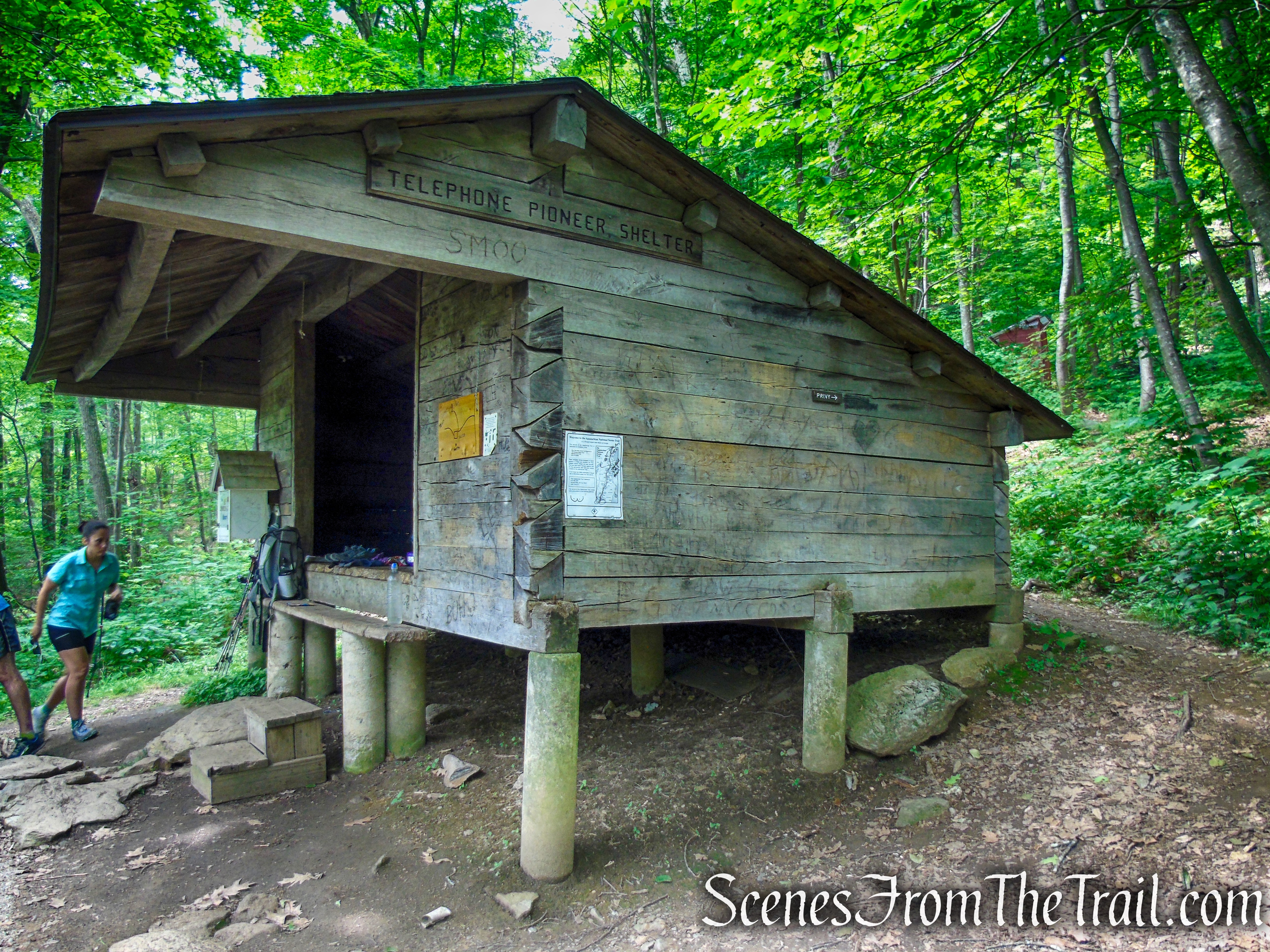
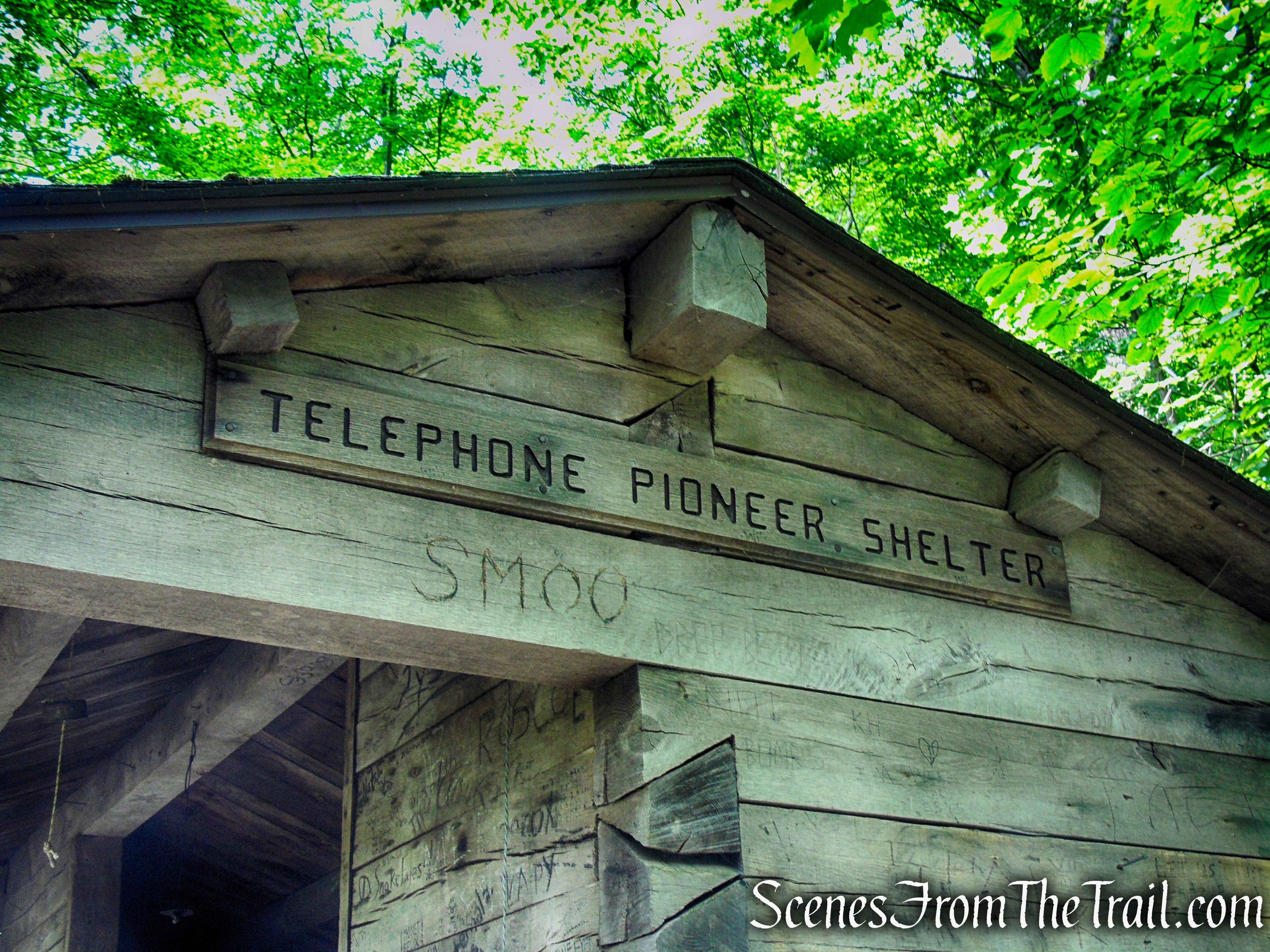
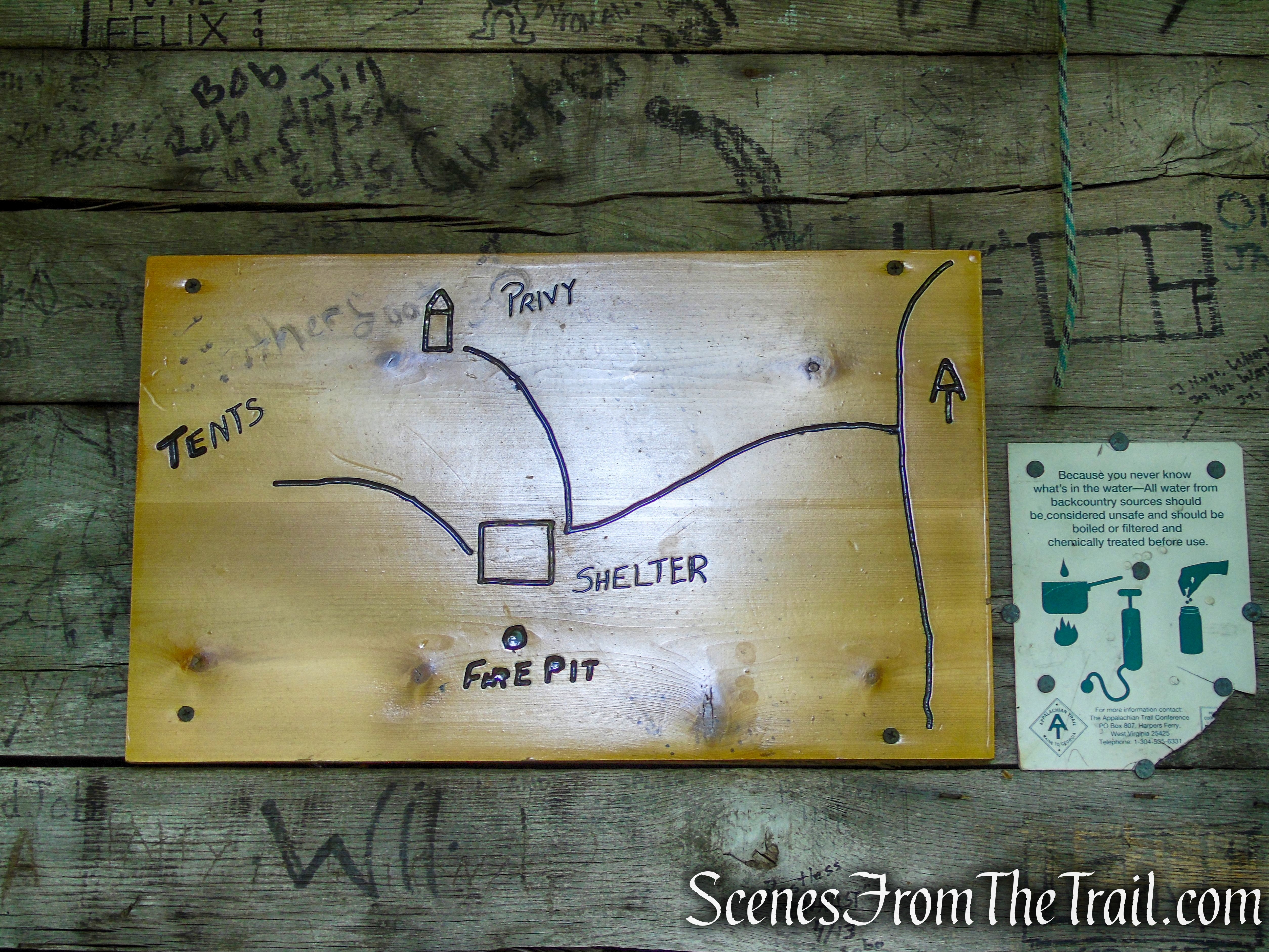
When you are done enjoying the view, retrace your steps back up to the Appalachian Trail and turn left, retracing your steps down West Mountain. When you reach the junction where the side trail leads to the Telephone Pioneers Shelter, bear right and follow the blue-blazed trail, which crosses a stream on rocks and leads in 500 feet to the shelter, constructed by the White Plains Council of the Telephone Pioneers of America in 1988. The picnic table in front of the shelter is a great spot to eat lunch or just take a break.

continue ahead to the Telephone Pioneers Shelter
Telephone Pioneers Shelter – Appalachian Trail

Telephone Pioneers Shelter – Appalachian Trail

Telephone Pioneers Shelter – Appalachian Trail
The materials to build this shelter were helicoptered in, via a giant Connecticut Army/Air National Guard Sikorsky S-64 Skycrane. The Pioneers took care of a lot of the advance work, but many local volunteers assisted the Pioneers in this massive 1988 undertaking, including the Pawling Boy Scout troop and Dutchess AT volunteers.
Telephone Pioneers Shelter – Appalachian Trail
The total materials cost for the project (mostly donated) was about $4,000. The wood was not cut in advance, all the notching work was done right on the site.
Telephone Pioneers Shelter – Appalachian Trail
AT Guide: “Built in 1988, with assistance from the White Plains Council of the Telephone Pioneers of America…0.1 mile from A.T. on side trail; accommodates 6; water from stream crossed by side trail to shelter; privy 200 feet from shelter on side trail.”
Telephone Pioneers Shelter – Appalachian Trail
When you’re ready to continue, retrace your steps back to the A.T. and bear right at the junction and continue descending West Mountain on the Appalachian Trail. Just before reaching the rock scramble, turn right on the unmarked bypass trail (unless you want to scramble down) and follow the footpath as it runs parallel to the towering rock formation that you scrambled over earlier.

Appalachian Trail – Pawling, NY

Appalachian Trail – Pawling, NY

Appalachian Trail – Pawling, NY
Turn right on the unmarked bypass trail which descends steeply around the base of the rock formation. At the base of the descent, the unmarked footpath climbs to a T-intersection with the Appalachian Trail. Turn right and follow the white blazes back to West Dover Road, where the hike began.

turn right on unmarked bypass trail

unmarked bypass trail

unmarked bypass trail

unmarked bypass trail

unmarked bypass trail

unmarked bypass trail

unmarked bypass trail

Appalachian Trail – Pawling, NY

Appalachian Trail at West Dover Road – Pawling, NY
Review:
A short but sweet hike on the Appalachian Trail. The far reaching views are outstanding and a great way to spend a few hours outdoors. The initial climb will get your heart pumping, but the reward is worth every step. This is one of those must do hikes in the area. I highly recommend it. The hike could be made longer by continuing on the AT past Cat Rocks or by using a different starting point.
Pros:
Appalachian Trail, well marked and maintained trail, lesser foot traffic than other places with great views, scenic landscape, Dover Oak.
Cons:
Some road noise can be heard.
Take a hike!

Cat Rocks – Pawling, NY
Sources:
- New York-New Jersey Trail Conference
- Hiking: Materials airlifted for Pioneers Shelter
- Appalachian Trail Conservancy
- Firefighters rescue hiker who fell more than 50 feet

thanks this was very cool reading and info very nice pic’s. thanks for reminding me of what a great area in live in here Westchester NY,
LikeLike