April 17, 2020 – Sleepy Hollow, NY
Difficulty: Easy – Moderate (distance)
Length: approximately 6.5 miles
Max elevation: 314 ft. – total elevation gain: approximately 590 ft.
Route type: Circuit
Map: 2020 Westchester Trails Map – Rockefeller State Park Preserve Free Map
Trailhead parking: Gory Brook Rd, Sleepy Hollow, NY 10591
Park Overview:
Rockefeller State Park Preserve offers quiet countryside walks of all lengths through forested hills and valleys surrounding sunlit pastoral fields. Managed by New York State Office of Parks, Recreation, and Historic Preservation, the Preserve is open to the public year-round, sunrise to sunset. The trails of the Preserve are crushed stone carriage roads laid out by John D. Rockefeller Sr. and Jr. in the first half of the 20th century. Designed to compliment the landscape, the 55 miles of scenic carriage roads are wide and easy to walk. Popular for walking, riding, jogging, and carriage driving, combinations of trails lead through varied landscapes and past natural and historical features, such as Swan Lake, the Pocantico River with its wood and stone bridges, gurgling streams, colonial stone walls and rock outcroppings. The carriage roads are the constant feature in what is otherwise a diverse and complex natural landscape of seemingly innumerable characteristics.

Rockefeller State Park Preserve
History:
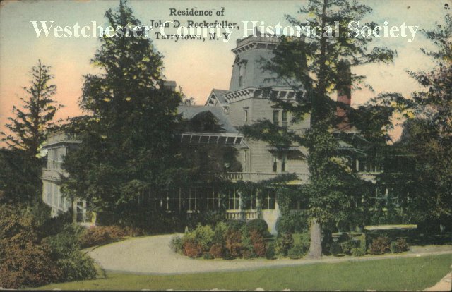
In 1886, William Rockefeller bought the 200-acre estate and castle, Rockwood, from the heirs of William Henry Aspinwall. Seven years later, John D. Rockefeller bought land in 1893 at Pocantico Hills.

Rockwood Hall
That same year, John D. Rockefeller Sr. and Jr. started purchasing land immediately around the family home, Kykuit, forming an enclosed estate of approximately 300 acres. Gradually, more than 3,000 acres of the surrounding rolling farmlands and woods were also acquired. During the summer of 1902, the first Rockefeller home at Kykuit, the Parsons-Wentworth House, burned down.
Parsons-Wentworth House
Kykuit, derived from the Dutch word Kijkuit meaning “lookout,” is situated on the highest point in Pocantico Hills, overlooking the Hudson River. The family estate was rebuilt and completed in 1913 in its present four-story Classical Revival Georgian form. The imposing structure, of local stone topped with the Rockefeller emblem, is located centrally in a 250-acres inner compound (referred to as “the Park”) within the larger Rockefeller family estate. This gated compound is guarded at all times. Save family residences, the rest of the estate (known as the open space) is open to the public for recreational purposes, as it always has been.
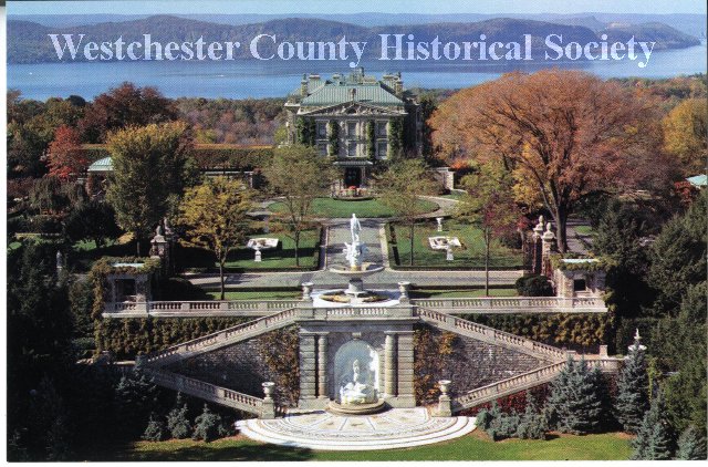
Kykuit
Beginning in 1910, John D. Rockefeller Sr. and Jr. worked together to lay out a system of broken stone roads surrounding Kykuit. As the system of carriage roads extended into outlying family properties, Junior assumed the lead role in overseeing their construction. Junior made a commitment to a social compact by ensuring that the roads were open to the public for walking, riding, and carriage driving as soon as they were built.
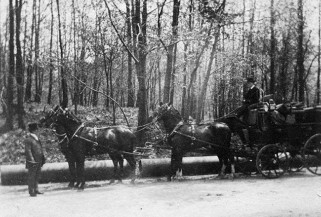
John D. Rockefeller Sr.
Rockefeller State Park Preserve has been made possible by the farsighted and generous gift of the Rockefeller family. Since 1983, over 1,600 acres have been deeded over to the State of New York to protect the scenic and natural beauty of the area for the public to enjoy.
Trails Overview:
Rockefeller State Park Preserve’s network of carriage roads are not blazed. There are signposts with trail names at most major junctions. This can be a little confusing at times and even though I have been there numerous times, I have taken a wrong turn on occasion.
My advice is to print out the trail map and download the Avenza Maps app (FREE). You can then download the free Rockefeller State Park Preserve map through the app or purchase the NY-NJ Trail Conference Westchester Trails Map for Avenza (more detailed), which can be purchased as a bundle ($11.95) or just a single map ($3.99). This will tell you exactly where you are on the trail and you can record your track and mileage.
Hike Overview:
With all the social distancing and parks being overcrowded lately, it’s put a damper on my hiking plans. Trying to stay local, recently I’ve been hitting some places that I would normally reserve for cold weather and/or when there is snow on the ground.
Growing up in the area, I have been hiking the Rockefeller woods since I was a kid. We didn’t call it hiking back then, we would just say “let’s go for a walk in the woods” or “let’s go up to Rockefeller’s.” We spent many a day exploring these woods without hiking boots, maps or carrying water. We sipped from the streams and only headed home when we were hungry. Even as a young adult, we had plenty of keg parties and bonfires in those woods, Gory Brook Road being our favorite point of entry. We used to drive down that road, evading potholes along the way and drinking warm and foamy beer along the banks of Gory Brook and the Pocantico River.
This hike revisits some of the areas that I explored in my youth and at the same time avoids some of the more heavily trafficked areas of the preserve. We started out on Gory Brook Road with no real plan and just improvised.
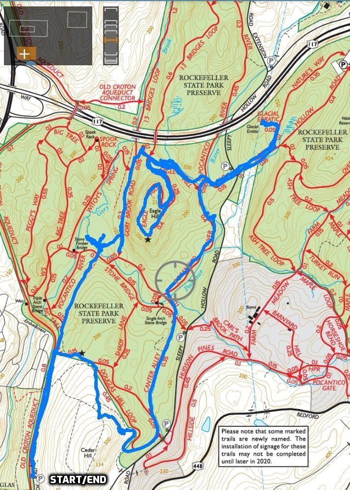
Rockefeller State Park Preserve via Gory Brook Road
The Hike:
Wanting to take a walk down memory lane, we started at the end of the paved section of Gory Brook Road. We started at about 8:45 am on a Friday morning and there were no cars when we arrived. We walked past the chain strung across the road, leaving the pavement and began walking on the gravel road which closely parallels the Old Croton Aqueduct, which would be our return route.
Gory Brook Road
Gory Brook Road
Gory Brook Road
The chained off section of Gory Brook Road is an abandoned Village-owned roadbed that runs north from the main built area of Sleepy Hollow through the Rockefeller State Park Preserve to Sleepy Hollow Road in the Town of Mount Pleasant. This informal trail links the Village of Sleepy Hollow (North Tarrytown until 1996) with the network of Trails in the Rockefeller State Park Preserve.
Gory Brook Road

Gory Brook Road
This stone entranceway used to lead to Long View, the thirty-eight-acre estate of Henry L. Douglas, that stood on Cedar Hill east of the Old Croton Aqueduct. Douglas first came to this area in 1868. Douglas Park was named for stockbroker John Douglas (d. 1883). John Douglas was the brother of Henry L. Douglas, who owned the adjoining land in the 1880’s. The Douglas mansion stood on the hill above the park. Henry L. Douglas occupied the mansion from the 1880’s until about 1900.

Gory Brook Road

Black Squirrel – Gory Brook Road
When the gravel road turns left (Big Tree Trail) we continued ahead to remain on Gory Brook Road.
continue straight on Gory Brook Road

Gory Brook Road
After about 0.8 mile, Gory Brook Road crosses the Pocantico River Trail. Just ahead is the Gory Brook Road Bridge that carries the old road over the Gory Brook.
Gory Brook Road
Gory Brook Road
Gory Brook – Three theories are offered for this brook’s name: (1) local bloody encounters during the Revolution; (2) hogs were once butchered nearby; (3) the name has been shortened from the name Gregory. Take your pick. Gory Brook runs south into the Pocantico River near Gory Brook Road, four-tenths of a mile from Route 9.

Gory Brook
Gory Brook Road Bridge

White-tailed deer – Rockefeller State Park Preserve
White-tailed deer – Rockefeller State Park Preserve
We spent a little time exploring this area that we used to frequent as kids.
Gory Brook
Gory Brook
Old Gory Brook Road becomes hard to follow after the bridge so we bushwacked across the field to the Gory Brook Road Trail, a carriage road. It runs just above the old road which becomes discernible at times just below this carriage road. We followed this carriage road past the junction with the Witch’s Spring Trail and just before reaching Rt. 117 that runs overhead, we turned right towards the Eagle Hill Trail.

Gory Brook Road Trail
Eagle Hill:
The carriage road ascends to a three way junction where the Eagle Hill Trail splits. Stay right at the junction and follow it uphill. In a short distance, the road comes to a fork. Either way is fine because the Eagle Hill Trail loops around and comes back to that spot.

Eagle Hill Trail – Rockefeller State Park Preserve
Eagle Hill Trail – Rockefeller State Park Preserve
At the top of the rise you will have arrived at the summit of Eagle Hill. Us locals always called it Eagle Mountain and I never heard it referred to as Eagle Hill until they installed the trail signs. To the southeast on the highest point, is Kykuit, the Rockefeller family estate.
Eagle Hill Trail – Rockefeller State Park Preserve
You may need binoculars or a decent zoom lens to get a better view of it.
Eagle Hill Trail – Rockefeller State Park Preserve
As you continue along the road, there are openings in the trees where you can see the Hudson River and the Tappan Zee Bridge.
Eagle Hill Trail – Rockefeller State Park Preserve
The Eagle Hill Trail curves around the summit, descends to the fork, turns left and returns to the 3-way junction. Turn right at the junction to continue following the Eagle Hill Trail. The trail heads downhill and soon ends at a T-intersection with the Pocantico River Trail. Turn left and almost immediately turn right on the Old Sleepy Hollow Trail.
Eagle Hill Trail – Rockefeller State Park Preserve
Eagle Hill Trail – Rockefeller State Park Preserve
Glacial Erratic:
Follow the Old Sleepy Hollow Trail as it crosses the Pocantico River on a footbridge and ascends to crosses Sleepy Hollow Road. This is a busy road at times so take care crossing.
Old Sleepy Hollow Trail – Rockefeller State Park Preserve

Pocantico River upstream – Rockefeller State Park Preserve
Pocantico River downstream – Rockefeller State Park Preserve
Old Sleepy Hollow Trail – Rockefeller State Park Preserve
Continued to follow the Old Sleepy Hollow Trail as it ascends more steeply. In about 250 yards, look for the Nature’s Way Trail that begins on the left. Follow this trail for about 160 yards then turn left on the Glacial Erratic Trail.

Old Sleepy Hollow Trail – Rockefeller State Park Preserve
At almost 20 feet high and 65 feet in circumference, it is probably the largest glacial erratic to be found anywhere in Westchester County.

Glacial Erratic – Rockefeller State Park Preserve
There is a good article about its discovery in 1987 in the New York Times. It is 600 million years old and was carried and dropped here by the Late Wisconsin continental glacier from some mountaintop in the Hudson Highlands.
Glacial Erratic – Rockefeller State Park Preserve
A side view of this massive boulder resembles a hawk, in my opinion.
Glacial Erratic – Rockefeller State Park Preserve
Here’s how I see it. The orange line traces around the lower body and tail. The purple lines shows its wings partially spread as it’s about to take off.
Glacial Erratic – Rockefeller State Park Preserve
Pocantico River Trail:
When you are done marveling at the massive boulder, retrace your steps back to the footbridge (don’t forget to look both ways before crossing the road!) and turn left after crossing the bridge.

Old Sleepy Hollow Trail – Rockefeller State Park Preserve
You are now following the Pocantico River Trail which winds along the edge of the Pocantico River. Take time to enjoy the stroll along this carriage road, stopping to view the cascades as they tumble over the rocks.

Pocantico River Trail – Rockefeller State Park Preserve

Pocantico River Trail – Rockefeller State Park Preserve

Pocantico River Trail – Rockefeller State Park Preserve

Pocantico River Trail – Rockefeller State Park Preserve
Just ahead is a single arch stone bridge. There are several ways to go here. We stayed left and crossed a small footbridge that connects to the Canter Alley Trail.
Pocantico River Trail – Rockefeller State Park Preserve
Canter Alley Trail:
The view of the stone bridge and the Pocantico River is nice from the simple footbridge.
Canter Alley Trail – Rockefeller State Park Preserve
The Canter Alley Trail parallels Sleepy Hollow Road (the road that you crossed earlier) and a small stream, and crosses several footbridges. Soon it passes open fields that are lined with trees.

Canter Alley Trail – Rockefeller State Park Preserve
Canter Alley Trail – Rockefeller State Park Preserve
View west from the Canter Alley Trail.

Canter Alley Trail – Rockefeller State Park Preserve
The trail heads south and you may encounter walkers or runners as the trail runs fairly close to Sleepy Hollow Road and several access points.

Canter Alley Trail – Rockefeller State Park Preserve
View west from the Canter Alley Trail.

Canter Alley Trail – Rockefeller State Park Preserve
Turning around, Eagle Hill is visible to the north.
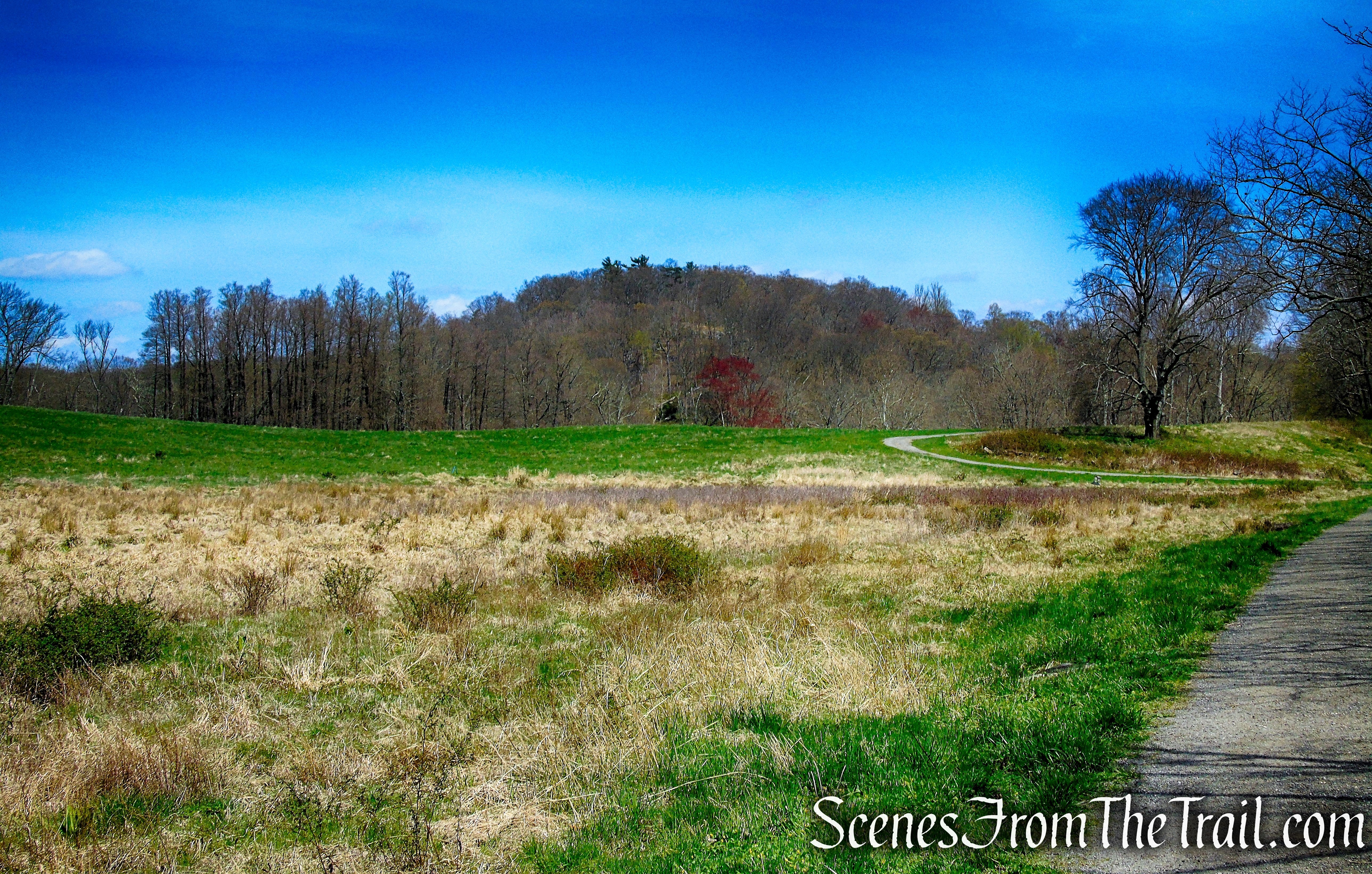
Canter Alley Trail – Rockefeller State Park Preserve
The Canter Alley Trail ends at a T-intersection with the Douglas Hill Loop Trail. Turn left and continue in a southerly direction. A short distance later the trail comes to a fork, bear right to stay on the Douglas Hill Loop Trail. The trail that goes under the bridge, leads to Stone Barns.
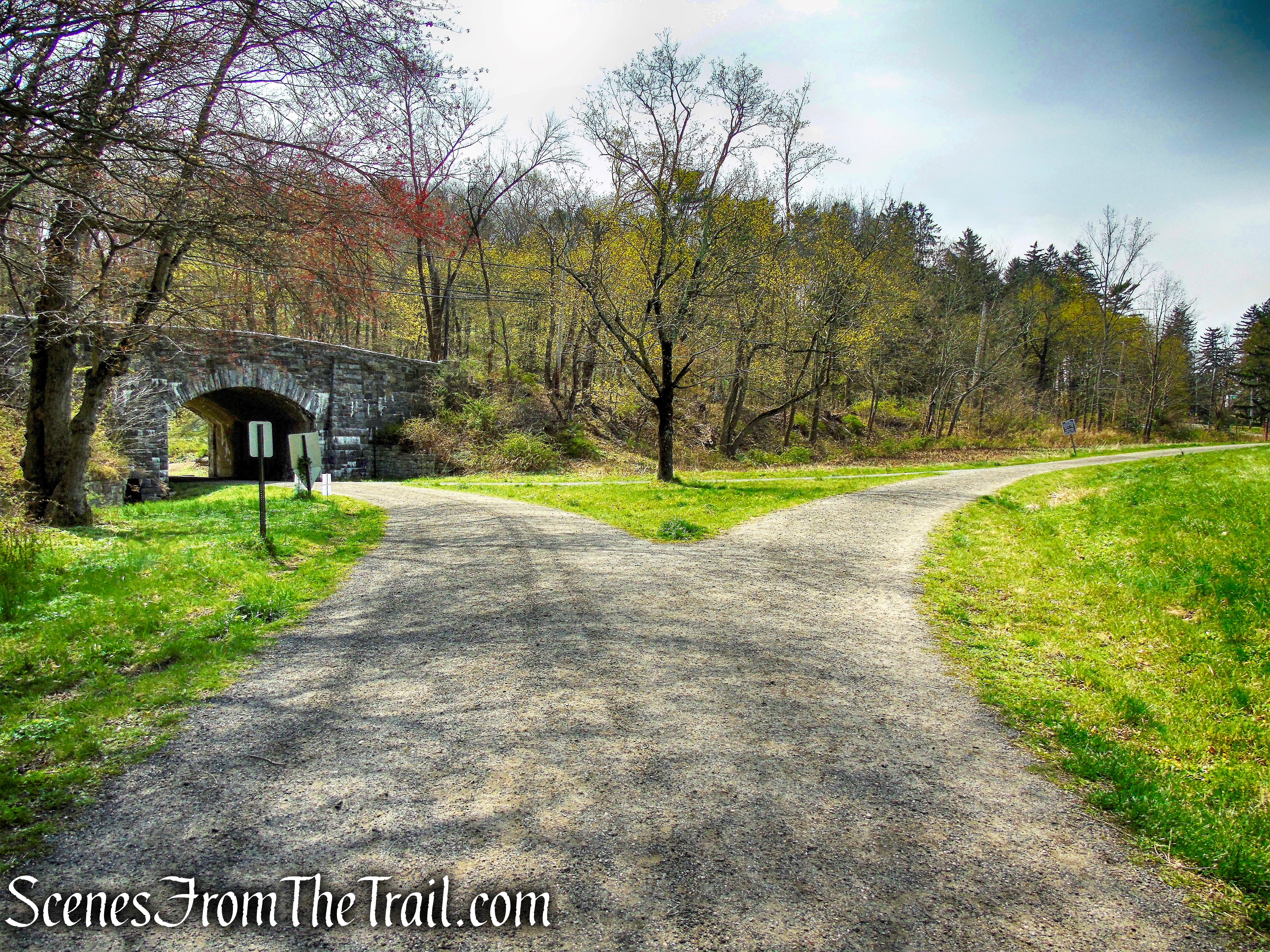
Douglas Hill Loop Trail – Rockefeller State Park Preserve
Cedar Hill:
This section is not technically part of Rockefeller State Park Preserve, but I eyed a lovely lunch spot from afar and decided to make a slight detour. This carriage road is just above the Douglas Hill Loop Trail and offers some fine views of the area we just traveled through.
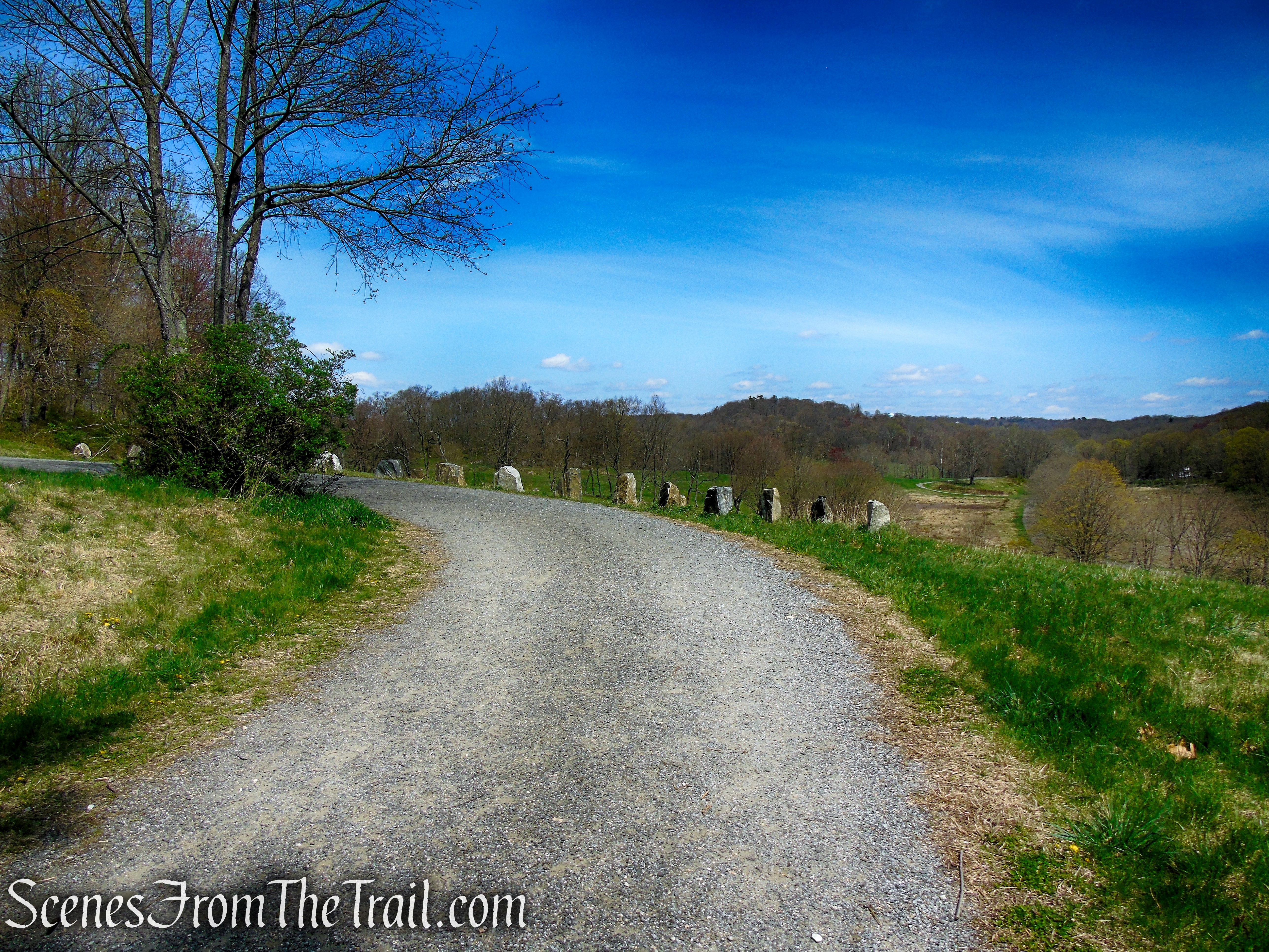
Cedar Hill – Rockefeller State Park Preserve

Cedar Hill – Rockefeller State Park Preserve
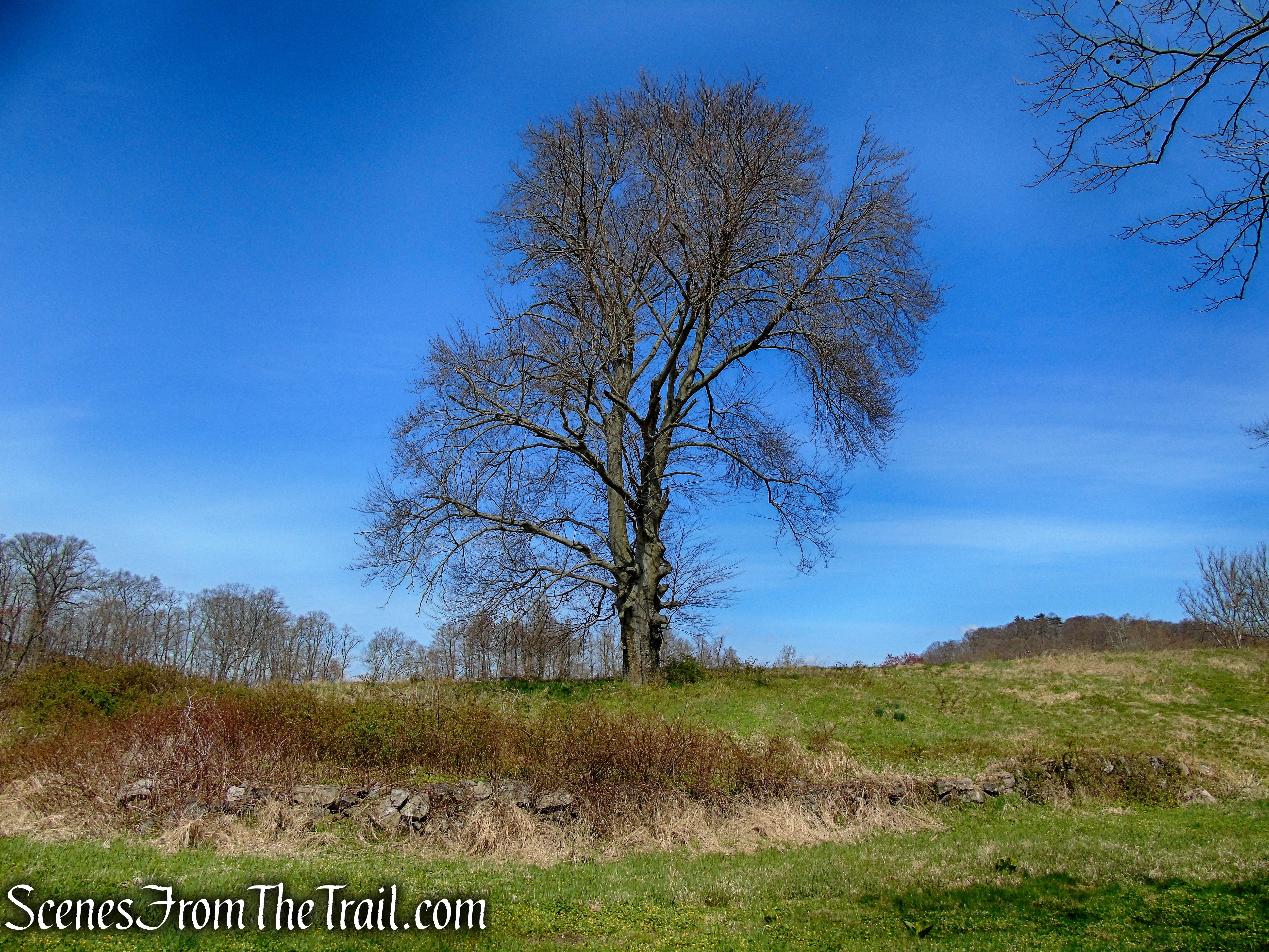
The carriage road climbs Cedar Hill and we veered off it to a nice rock formation near the summit that overlooks the fields below.
Cedar Hill – Rockefeller State Park Preserve
We sat here and enjoyed a nice roast beef wedge from the Tarrytown Deli, they make their own roast beef and it’s delicious.
Cedar Hill – Rockefeller State Park Preserve
When we were done with lunch, we walked to the west side of Cedar Hill and were welcomed with a decent view of the Hudson River.
Cedar Hill – Rockefeller State Park Preserve
Since we weren’t sure if we were allowed to be there (no signs), we cut across the field and rejoined the Douglas Hill Loop Trail, just north of Cedar Hill.
Cedar Hill – Rockefeller State Park Preserve
Douglas Hill Loop Trail – Rockefeller State Park Preserve
On the way down there is a north-facing view across a field, with Eagle Hill visible in the distance.
Douglas Hill Loop Trail – Rockefeller State Park Preserve
Old Croton Aqueduct:
The Douglas Hill Loop Trail ends at Gory Brook Road. We crossed the road and walked a few feet to The Aqueduct and turned left. I didn’t feel like returning on the same road, plus I was searching for an engraved stone along The Aqueduct.

Old Croton Aqueduct
This stone engraved with initials and the year 1879, I have seen in the past and always wondered about it. Someone inquired about it recently so I did some digging. I am not sure if my findings are correct, but here goes. The thirty-eight-acre estate of Henry L. Douglas, stood on Cedar Hill just east of this spot. We passed the stone entrance-way at the start of the hike and it is close by. This stone retaining wall holds up Gory Brook Road. That tells me that this section of Gory Brook Road was either built or improved in 1879 and the initials probably belong to the worker(s). Henry L. Douglas occupied the mansion on Cedar Hill from the 1880’s until about 1900. Makes sense to me, but I could be wrong.

Old Croton Aqueduct
Old Croton Aqueduct

Old Croton Aqueduct
Old Croton Aqueduct
Review:
The allure of Rockefeller State Park Preserve comes from the carriage roads that take you through the diverse landscapes. Whether it be the meadows, streams, stone walls or rock formations, this park is scenic throughout. Walking along these historical carriage roads give you a sense of being out in the country. Most visitors have no idea that they are in a designed environment, which attests to the genius of John D. Rockefeller, Jr’s design and insight as a landscape architect and naturalist. Perfect for a tranquil walk in all seasons.
Pros:
Historical features, glacial erratic, Gory Brook, Pocantico River, scenic landscape.
Cons:
Highly trafficked near parking areas.
Take a hike!

Rockefeller State Park Preserve via Gory Brook Road
Sources:

Wondering who wrote this, loved the piece with fond memories of Rockwood, long before it was a “park” remembering keg parties and sleigh riding down laughing hill. SHHS graduate of 1971 and you?
On Thu, Apr 23, 2020 at 4:36 PM Scenes From The Trail wrote:
> Outlaw_Hiker posted: “April 17, 2020 – Sleepy Hollow, NY Difficulty: Easy > – Moderate (distance) Length: approximately 6.5 miles Max elevation: 314 > ft. – total elevation gain: approximately 590 ft. Route type: Circuit Map: > 2020 Westchester Trails Map – Rockefeller State Pa” >
LikeLike
I wrote it, SHHS class of ’79. Spent my youth in those woods and skipping class up at Rockwood.
LikeLike
You proved your bonfides my referring to “Eagle Mountain”, having a “wedge” for lunch and having keg parties. SHHS Class of 74
LikeLike
Enjoy the hike, been trying to go but now I did will come back again and will tell my friends
LikeLiked by 1 person