October 7, 2018 – Rosendale, NY
Difficulty: Easy – Moderate
Length: approximately 3.3 miles
Max elevation: 400 ft. – total elevation gain: 543 ft.
Route type: Out and back
Map: Wallkill Valley Rail Trail
Trailhead parking: Binnewater Kiln Parking Lot – Kingston, NY 12401
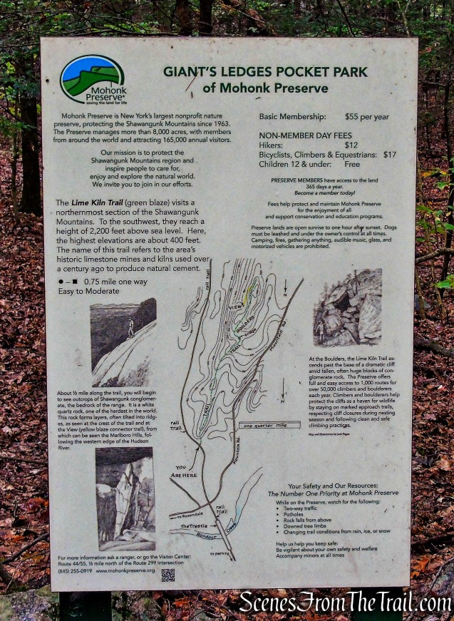
In 2011, Mohonk Preserve acquired Giant’s Ledges, an iconic 142.5 acre parcel in Rosendale, which extends permanent protection to the northernmost section of the Shawangunks. The massive ledge of Shawangunk Conglomerate stretches from Bonticou Crag north, all the way to the hamlet of Rosendale. Known locally as the “Giant’s Ledges” for its dramatic views, impressive boulders, and talus fields, made up of rock fragments, it links the Northern Preserve to the Wallkill Valley Rail Trail.
Giant’s Ledges Pocket Park
Having recently only just learned of this park, I was intrigued and decided to pay it a visit. Having planned a short hike on Joppenbergh Mountain, I was looking for elsewhere to hike in the immediate area to justify a 1-1/2 hour drive from Westchester County. Giant’s Ledge was a perfect fit and made the drive well worth it.

Giant’s Ledges Pocket Park
After completing the Joppenbergh Mountain Loop, we drove over to the Binnewater Kiln Parking Lot, which provides access to the Wallkill Valley Rail Trail. It is a large gravel parking area across from the entrance to the Wallkill Valley Rail Trail on Binnewater Road. It’s marked by a pedestrian crossing and “Rail Trail” signs.

Binnewater Kiln Parking Lot
At the rear of the parking area there is a wall of kilns that were used in the production of Rosendale Cement. The area quickly developed into the largest single production source of natural cements. By 1830, nearly 10 million pounds per year of natural cement were being produced, marking the beginning of its commercialization.
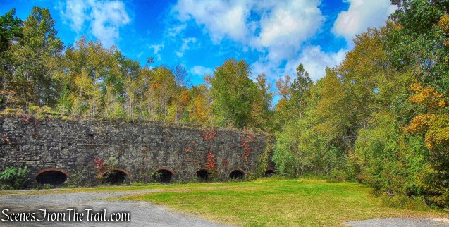
Binnewater Kiln Parking Lot

Binnewater Kiln Parking Lot
We crossed Binnewater Road and made our way to the Wallkill Valley Rail Trail.

Wallkill Valley Rail Trail
We turned right on the Rail Trail and began heading south, with the base of Joppenbergh Mountain to our left.

heading south on the Wallkill Valley Rail Trail
In a short distance we came to mile marker 15.5 of the Wallkill Valley Rail Trail. A large mine sits close by that gives off some cool air.

Wallkill Valley Rail Trail
We stopped here for a few minutes to examine the mine and suck up some free air conditioning.

Joppenbergh Mountain mine
The entrance to this mine is quite large.

Joppenbergh Mountain mine
The mine appears to undercut the Rail Trail.

Joppenbergh Mountain mine
As we continued south, we passed some old railroad ties that were removed from the trestle.

Wallkill Valley Rail Trail
We then reached the Rosendale Trestle.

Rosendale Trestle
The Rosendale Trestle is a 940-foot continuous truss bridge and former railroad trestle. Originally constructed by the Wallkill Valley Railroad to continue its rail line from New Paltz to Kingston, the bridge rises 150 ft. above Rondout Creek, spanning both Route 213 and the former Delaware and Hudson Canal. Construction on the trestle began in late 1870, and continued until early 1872. When it opened to rail traffic on April 6, 1872, the Rosendale Trestle was the highest span bridge in the United States.

Rosendale Trestle
The Wallkill Valley rail line was closed in 1977 and the trestle renovated as a pedestrian walkway for the Wallkill Valley Rail Trail. It opened to the public with a celebration on June 29, 2013.

Rosendale Trestle
Looking southwest at Rondout Creek.

Rosendale Trestle
Turning around, the scarred face of Joppenbergh Mountain, where we had just been a little earlier.

Joppenbergh Mountain
Looking east from the trestle.

Surprisingly, there were hardly any people on the trestle as we crossed. Normally there is quite a lot of foot traffic here.
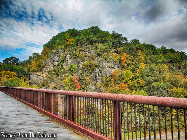
Joppenbergh Mountain as viewed from the Rosendale Trestle
We continued south on Wallkill Valley Rail Trail to the southern end of the trestle.

Rosendale Trestle
After crossing the trestle, we continued straight on the Rail Trail.

Wallkill Valley Rail Trail
In a short distance, we crossed Mountain Road and continued ahead on the Wallkill Valley Rail Trail.

Wallkill Valley Rail Trail
We then passed mile marker 15.

Wallkill Valley Rail Trail
Continuing south on the Rail Trail, we only saw several cyclists on such a beautiful day.

Wallkill Valley Rail Trail
About a 1/2 mile later, shortly before the 14.5 mile marker, the trailhead for the green-blazed Lime Kiln Trail in Giant’s Ledges Pocket Park, begins to the right.
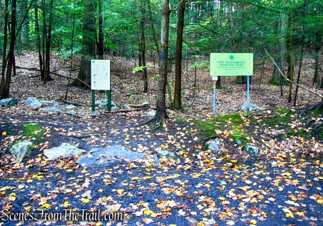
Giant’s Ledges Pocket Park

Giant’s Ledges Pocket Park
I could not find a map online, but the map on the sign is helpful. It isn’t quite accurate, as the Yellow Trail on the map ends at the view, but in reality continues heading north. I think that it connects with a woods road that leads back to the Lime Kiln Trail.
Giant’s Ledges Pocket Park
The green-blazed Lime Kiln Trail is 0.75 mile long (one way) and visits the northernmost section of the Shawangunk Mountains. To the southwest, they reach a height of 2,200 feet above sea level. Here, the highest elevations are about 400 feet.

Lime Kiln Trail – Giant’s Ledges Pocket Park
The name of the trail refers to the area’s historic limestone mines and kilns used over a century ago to produce natural cement. The dark green blazes are at times difficult to see, but the trail itself is discernible.

Lime Kiln Trail – Giant’s Ledges Pocket Park
The trail passes a woods road with a private property sign. I think that this is the road that links up with the Yellow Trail.

Lime Kiln Trail – Giant’s Ledges Pocket Park
I believe that “DO NOT ENTER” refers to cyclists and not hikers. The sign reads at the bottom: “Mohonk Preserve” and as long as you are a member or pay the hiking fee, there shouldn’t be an issue.

Lime Kiln Trail – Giant’s Ledges Pocket Park
The Lime Kiln Trail crosses a small wooden footbridge over a stream, then bears left.

Lime Kiln Trail – Giant’s Ledges Pocket Park
The trail then enters an area called “The Boulders.”

Lime Kiln Trail – Giant’s Ledges Pocket Park
As we passed by, a group of climbers were setting up. It must have been too wet for them because on our return, they were gone.

The Boulders – Giant’s Ledges Pocket Park
At The Boulders, the Lime Kiln Trail ascends past the base of a dramatic cliff amid fallen, often huge blocks of conglomerate rock.

Lime Kiln Trail – Giant’s Ledges Pocket Park
At the top of the rise, the Lime Kiln Trail ends at a junction with the start of the Yellow Trail. The Yellow Trail turns a sharp left, heads north and passes above the area of The Boulders. This turn can be easily missed because although the green blazes end here, the trail itself continues heading south, entering other areas of the Mohonk Preserve.

Yellow Trail – Giant’s Ledges Pocket Park
Now following the yellow blazes, the trail is carpeted with pine needles.

Yellow Trail – Giant’s Ledges Pocket Park
In a short distance we reached what I have seen referred to on several maps as the “White Dot” viewpoint.

Yellow Trail – Giant’s Ledges Pocket Park
The east-facing viewpoint from Giant’s Ledges.

Giant’s Ledges Pocket Park
The Marlboro Mountains are visible in the distance.

Giant’s Ledges Pocket Park

Giant’s Ledges Pocket Park
Past the viewpoint, the Yellow Trail descends and continues north. Being unsure at the time of where it leads, we did not go any farther than the viewpoint. We retraced our steps back to the Lime Kiln Trail where we turned right.

Lime Kiln Trail – Giant’s Ledges Pocket Park
Passing through The Boulders area again.

The Boulders – Giant’s Ledges Pocket Park
There are many crevices and cave like areas where one can explore.

The Boulders – Giant’s Ledges Pocket Park
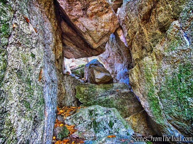
The Boulders – Giant’s Ledges Pocket Park
We then recrossed the small wooden footbridge and retraced our steps on the green-blazed Lime Kiln Trail all the way back to the Wallkill Valley Rail Trail, where we turned left and began heading north, back the way we came.

turn left onto the Wallkill Valley Rail Trail
We recrossed the Rosendale Trestle,

Rosendale Trestle
passing Joppenbergh Mountain along the way.

Joppenbergh Mountain as viewed from the Rosendale Trestle
We continued north on the Wallkill Valley Rail Trail and stopped at the mine for some free air conditioning again.

heading north on the Wallkill Valley Rail Trail
As the Wallkill Valley Rail Trail proceeds north to Kingston, we turned left to return back to the parking lot, where the hike began.

heading north on the Wallkill Valley Rail Trail

turn left to Binnewater Kiln Parking Lot
Cross Binnewater Road.

Binnewater Kiln Parking Lot
This was an excellent hike through a beautiful area that is not very well known. The Rosendale Trestle does attract crowds, but mixed in with Giant’s Ledges Pocket Park, it made for a really nice day on the trails.
Pros: Gorgeous scenery, historical features, Rosendale Trestle, Wallkill Valley Rail Trail, Giant’s Ledges Pocket Park.
Cons: A trail map of Giant’s Ledges Pocket Park would be very helpful.
Take a hike!

Giant’s Ledges Pocket Park – Mohonk Preserve
Sources:
- History of Rosendale Natural Cement
- A Celebration of the Rosendale Trestle
- Wallkill Valley Rail Trail
- Giant’s Ledges

With so many great free areas in the region to explore, I never considered Mohonk’s high fees to be “worth it”.
LikeLiked by 1 person