November 19, 2017 – Pound Ridge, NY
Difficulty: Moderate – strenuous
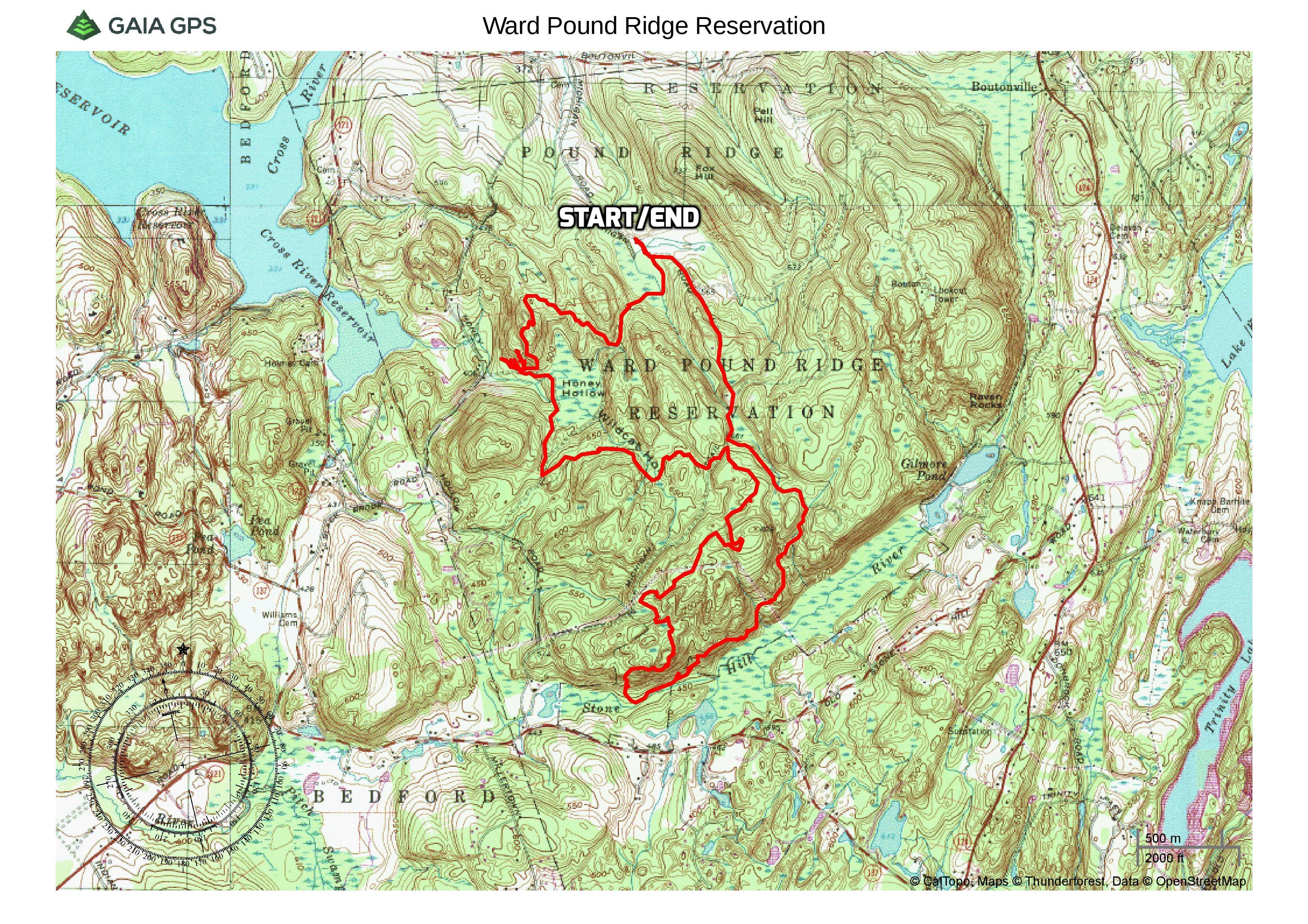
Length: Approximately 8.0 miles
Max elevation: 823 ft.– total elevation gain approximately 1,183 ft.
Route type: Circuit
Map: Web map – Map available at kiosk with admission
Parking fees: $5.00 with Westchester County Park Pass, $10.00 without Park Pass – daily May through mid-Oct; weekends only mid-Oct. through mid-May.
Trailhead parking: Michigan Road Parking Area – Pound Ridge, NY 10576
Ward Pound Ridge Reservation encompasses 4,315-acres and is Westchester County’s largest park. The name Pound Ridge is credited to the Indians who originally lived in the area. They had a local pound in which they kept game on the hoof until they needed it for food. The Indians built an enclosure of saplings driven into the ground and drove their game into the pound. The name was spelled “Poundridge” until 1938.
The reservation features 35 plus miles of hiking trails through various habitats. The many carriage road trails and stone walls meandering through the park are a testament to farming days gone by. More than thirty farms once existed within the park’s boundaries. The secondary trails are often less conspicuous and fun to explore.
Most trail intersections are marked by numbered signs posted on trees. These numbers are shown on the park map. Since the trail system in the park is complex, hikers should obtain a free park map before beginning the hike.
When I was a kid, we would go to Pound Ridge, as it was known then, and spend the night in one of the many lean-tos, with a bonfire and drinking warm beer until daylight. Away from the watchful eyes of adults, we were in heaven. Since those bygone days, I have never returned to the area. Fast forward many years later, I decided to map out a hike and revisit the park. If only it was that easy to revisit my youth, but I digress. I wanted to pack in as many points of interest as possible on the hike, but with its network of trails, I knew that I could bailout and shorten the hike if necessary. Having just done Breakneck Ridge and Sugarloaf Mountain two days earlier, I was not sure if I could do the entire loop that I had planned.
From the Michigan Road picnic area, the red trail offers access to the greatest variety of scenery along its 5.6 mile loop. The Leatherman’s Loop Trail travels to an overlook over the Cross River Reservoir and passes near the legendary Leatherman’s Cave on its 1.25 mile loop. The Rocks Trail takes hikers on a 4.9-mile circuit into the heart of Ward Pound Ridge to pass Indian Rock Shelter, Raven Rock, Castle Rock, Spy Rock, Bear Rock and Dancing Rock. Combining portions of these three main trails, along with some secondary trails (connector trails), this hike covers a good portion of the southwest section of the park.
Ward Pound Ridge Reservation
From the circle at the end of the Michigan Road parking area, we turned right and followed a road blocked by a wooden gate.
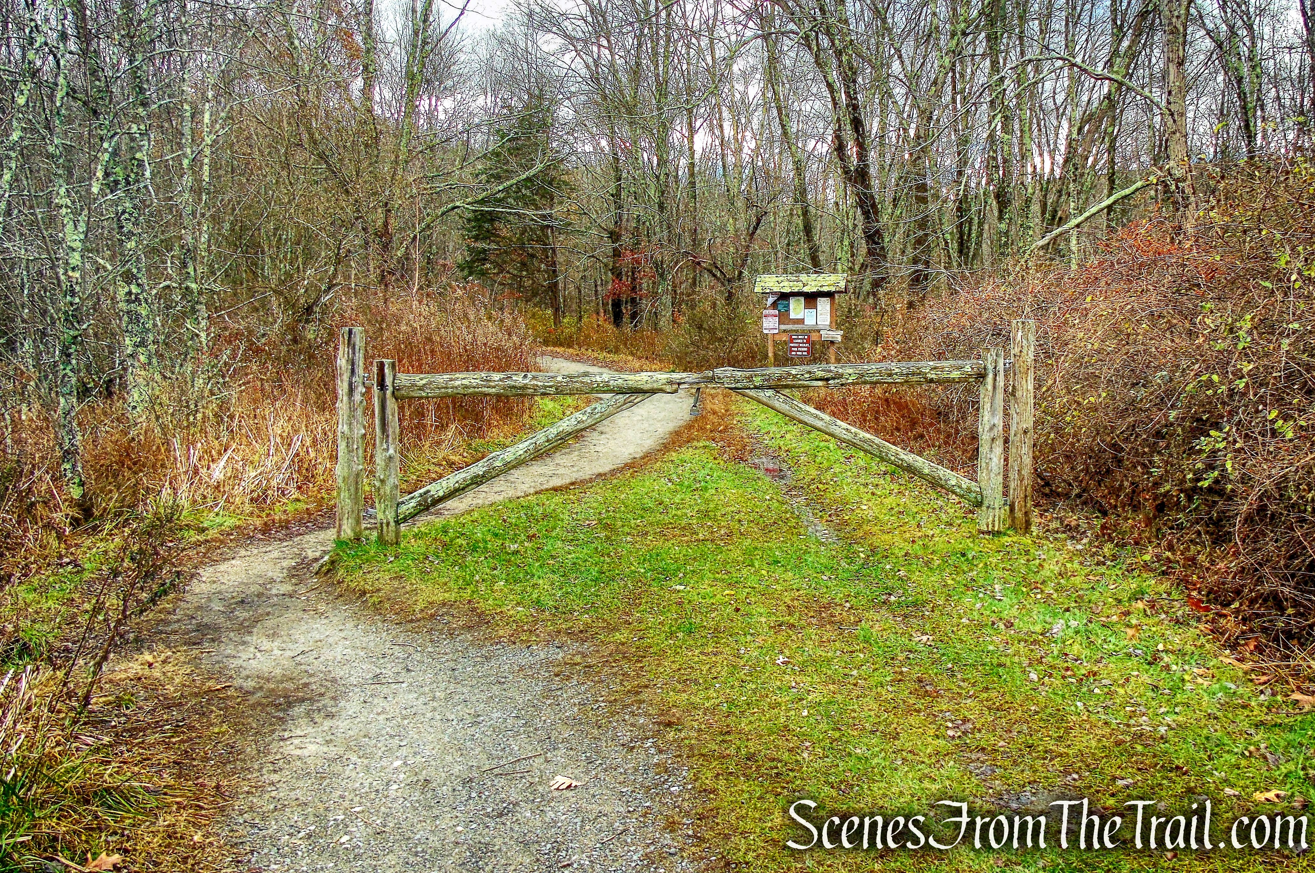
road blocked by a wooden gate
There are numerous junctions and intersections, but we ignored them and focused on the red and green blazes. The numbered intersections are quite useful and help to determine where exactly you are on the map. Hiking without a map and a compass in this park would be unwise. After passing the kiosk, we came to a fork, junction 70, and veered right, following the red and green blazes.
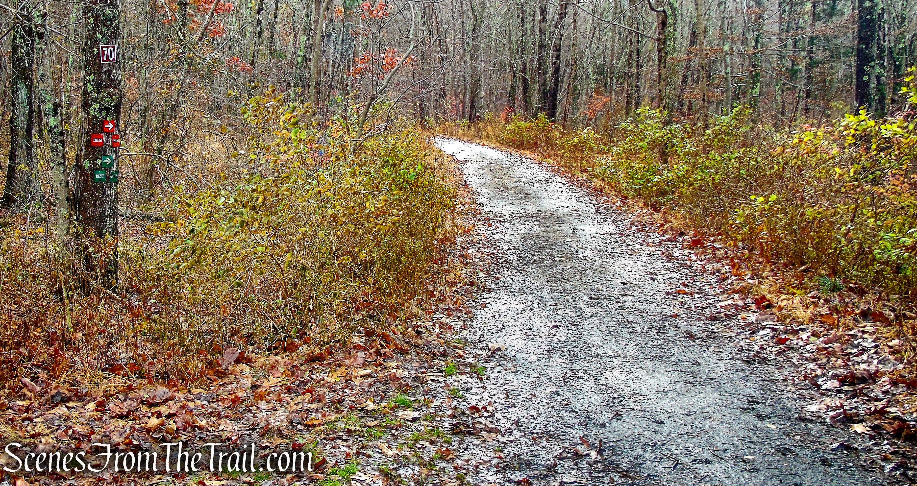
Start of the Red/Green Trail
The Red/Green Trail follows a woods road and is relatively level at this point.
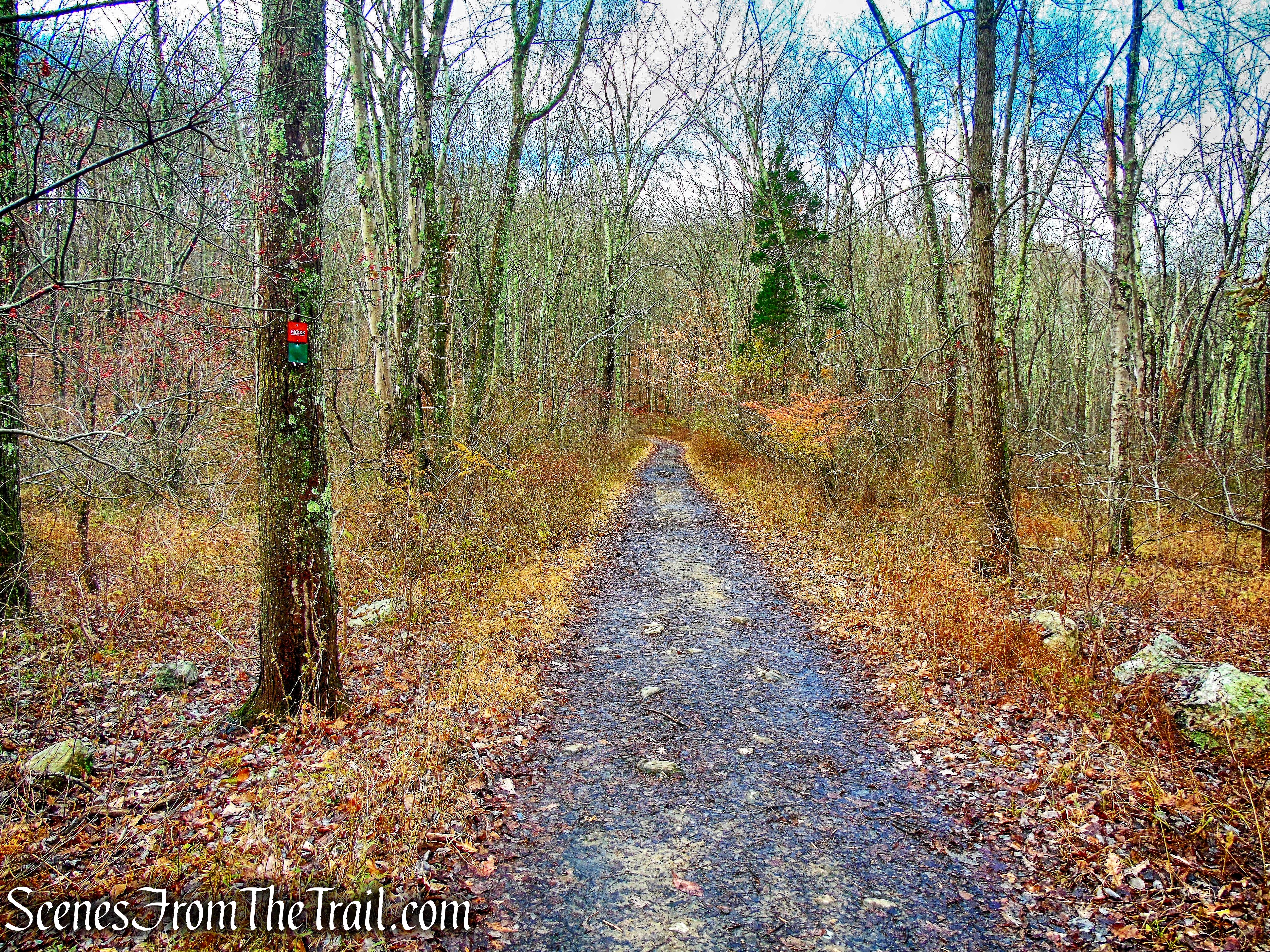
Red/Green Trail
After approximately 0.5 miles from the start, we arrived at junction 31. Here the Red/Green Trail goes to the left. We turned right onto the L-on-white-blazed Leatherman’s Loop Trail.
junction 31
The three blazes on a tree mark the start of the Leatherman’s Loop.
Leatherman’s Loop Trail
The Leatherman’s Loop Trail climbs gently through the woods and passes several other junctions. The trail is well marked and easy to follow.
Leatherman’s Loop Trail
Turning left at a T-intersection (junction 27), still following the “LL” blazes, the trail proceeds along a winding route to the top of a hill. Just to the right of the trail, rock ledges provide a west-facing viewpoint of the Cross River Reservoir.
west-facing viewpoint of the Cross River Reservoir
We stopped here briefly to take in the view, but it was so cold and windy that we didn’t stay long.
west-facing viewpoint of the Cross River Reservoir
We Continued heading south along the Leatherman’s Loop Trail, which descends steeply at times, on a footpath.
Leatherman’s Loop Trail
After passing a large rock overhang, we reached junction 29. Here we strayed a bit because there is supposed to be a sign on a tree that reads “Leatherman’s Cave.” We didn’t see a sign and we didn’t see any blazes. This area is just below the scenic overlook we were at, just moments before and there are numerous rock formations and cliffs. On top of that, there seems to be caves everywhere and not knowing what the Leatherman’s Cave looked like, made it that much more difficult.
Ward Pound Ridge Reservation
After searching for a little while, I found what looked like a footpath and what I assumed was the cave in question. I was able to confirm (after the hike) that this was indeed the Leatherman’s Cave.
Leatherman’s Cave
Attired in a patchwork of leather from head to toe, The Leatherman traveled a continuous 365 mile circuit in Connecticut & New York. The Leatherman’s timetable was set up so that he arrived in a separate locality each day, and his timing was so exact that housewives along his path “could set their clocks by him.” Some of the more well known caves that he used in Westchester include Bull’s Hill Cave in Bedford Hills, Helicker’s Cave in Armonk and the Leatherman’s Cave at Ward Pound Ridge Reservation.
Leatherman’s Cave
Once we got our fill of the cave, we retraced our steps back to the Leatherman’s Loop Trail and began heading east.
Leatherman’s Loop Trail
In a short distance, we came to junction 28 and turned right leaving the Leatherman’s Loop Trail. Along with the rest of the “secondary trails” that are listed on the map, it is marked with plain white blazes. The secondary trails are used to connect the main trails in the park.
secondary trail from junction 28
This trail passes through an area known as Honey Hollow on the map. It is very quiet and secluded.
Honey Hollow
After just under 0.5 miles, this trail ends at junction 30, at a Y-intersection with the Red/Green Trail. To the left, the Red/Green Trail heads north towards the parking area where we began our hike. We veered right, heading east on the Red/Green Trail.
Red/Green Trail
We stayed on Red/Green Trail for approximately 0.5 miles until we reached junction 34 and turned left. This trail winds through the woods on a footpath in an easterly direction.
secondary trail from junction 34
We stayed on this trail for approximately 0.42 miles until we reached junction 36. Here we turned right onto the Rocks Trail, marked with the letters “RT” on a white background.
Rocks Trail
The Rocks Trail proceeds uphill on a woods road. In about 0.5 miles at junction 37, a white-blazed trail begins to the left. Turning left and following this white secondary trail uphill, we came to Dancing Rock, a large flat rock where farmers used to dance to celebrate the conclusion of the harvest season.
Dancing Rock
The trail loops around and rejoins the Rocks Trail at junction 60. Turning left, we continued along the Rocks Trail, which climbs a little and crosses under power lines. It briefly parallels the power lines then bears left. As it descends through the woods, it passes Bear Rock to the right of the trail.
Bear Rock
Bear Rock is named for a petroglyph, a carving in the shape of a bear, on the west side of the rock.
Bear Rock petroglyph
After paralleling the power lines again, the trail reaches junction 39 and turns left. The Rocks Trail then passes through two sets of stone walls.
Rocks Trail
Rocks Trail
We continued following the Rocks Trail, which turns left and descends. At the base of the descent, we turned right and cross a seasonally wet area on puncheons and rocks. After crossing two more stone walls, the Rocks Trail turns sharply left and parallels a stone wall.
Rocks Trail
The Rocks Trail soon bears right, away from the stone wall and climbs to Spy Rock, with south-facing views through the trees.
Spy Rock
During the Revolutionary War, this rock ledge was used by the Americans to observe the movements of British troops.
Spy Rock
Now descending, steeply in spots, the Rocks Trail continues down into a gully, with impressive cliffs to the right.
Rocks Trail
Rocks Trail
The trail then climbs out of the gully and crosses a level area. It soon begins a steady descent, first gradually, then more steeply on a series of about 80 rock steps and continues through a mixed forest of fir and beech trees.
rock steps – Rocks Trail
At the base of the descent, the Rocks Trail heads northeast on a level woods road through a scenic valley. After crossing an intermittent stream and an old stone wall, the trail climbs more steeply. It levels off, then continues on an undulating route along the side of the hill, with several rather steep ups and downs. After briefly joining an old woods road, the Rocks Trail climbs and passes beneath the power lines. Just beyond the power lines, it passes a huge boulder to the left, known as Castle Rock.
Castle Rock
At this point, we were starting to wear down and decided to shorten the hike a little. I was a little disappointed because we skipped Raven Rock and Indian Rock, but we still had almost 1.75 miles to go in order to get back to where we started. At this point we had hiked over 6 miles and began to head back. At junction 59 we made a left and followed the white blazes to its terminus at junction 47 where we turned left on the Red Trail, which follows a woods road.
Red Trail
At junction 36, we turned right onto the Rocks Trail and walked a short distance to a Y-intersection with the Yellow Trail. We stayed left and began heading north, now following the yellow-blazed trail on a woods road.
Yellow Trail
We took the Yellow Trail for about 0.6 miles until we reached junction 24 and turned left. In a short distance, we reached junction 70, near the kiosk where we began our hike and turned right.
junction 70
We then walked past the kiosk, the wooden gate and back to the parking area where our hike began.
Ward Pound Ridge Reservation
This was a great hike and much more rugged than I had envisioned. The woods roads were easy going, but the footpaths provided enough ups and downs to wear us down. I would like to return at some future date and explore other areas of this park as it has enough points of interest to merit a return visit. The rock formations and cliffs are reminiscent of Harriman State Park and the section that we hiked is secluded and doesn’t seem to get a lot of foot traffic. Totally enjoyable and I highly recommend it.
To get a better idea of what the hike is like, view the short video below.
Pros: Leatherman’s Cave, massive rock formations and cliffs, secluded trails, scenic views, woods roads, rugged trails.
Cons: Parking fee
Take a hike!
Leatherman’s Cave
