August 18, 2026 – Sloatsburg, NY
Difficulty: Moderate
Length: approximately 4.3 miles
Max elevation: 1,043 ft.– total elevation gain 660 ft.
Route type: Circuit
Map: Harriman-Bear Mountain Trails Map #119
Trailhead parking: Johnsontown Circle Hiker Parking – 199-31 Johnsontown Rd, Sloatsburg, NY 10974
Click here to see Trail Alerts for Bear Mountain-Harriman State Parks
Overview:
Harriman State Park, located in Rockland and Orange counties, is the second-largest state park in New York and offers more than 200 miles of hiking trails across a rugged landscape of forested hills, rocky ridges, lakes, streams, and historic features. Its vast trail network provides everything from quiet woodland walks to challenging climbs and dramatic viewpoints.
Harriman State Park
Almost Perpendicular is one of the highlights of this moderate loop hike, reached after a climb along the Blue Disc Trail. Named for its imposing, near-vertical rock face, this dramatic cliff formation provides a spectacular perch above the surrounding landscape. From the open rock ledges at the top, wide-ranging views stretch across the rolling, forested hills of southwestern Harriman State Park.

Almost Perpendicular – Harriman State Park
Further along the route is Elbow Brush, an unusual rock formation that adds a bit of adventure to the hike. Here, the trail passes through a narrow rock tunnel, requiring hikers to squeeze between and beneath massive boulders as they make their way through the formation. It is a fun and memorable passage through Harriman’s rugged terrain and one of the loop’s more distinctive natural features.

Elbow Brush – Blue Disc Trail
The hike also visits Claudius Smith Rock, a prominent cliff-top formation associated with the legendary Revolutionary War-era outlaw Claudius Smith. At the base of Smith Rock is the rock shelter known as Claudius Smith Den, which local lore holds was one of his hiding places. A climb to the top of the rock is rewarded with another expansive view over Harriman’s wooded hills, providing a fitting finale to a loop filled with historic lore, fascinating rock formations, and scenic overlooks.

Claudius Smith Rock – Harriman State Park

Claudius Smith Den – Harriman State Park
Aside from its well-known points of interest, this route has plenty more to offer along the way. Interesting rock formations, ever-changing terrain, and scenic woodland landscapes keep the hike varied and engaging from start to finish.
History:
The dramatic cliff known as Almost Perpendicular was named by the Fresh Air Club in 1936. Rising from the rugged slopes of Dater Mountain, the name is a fitting description of the formation’s steep, nearly vertical rock face. Today, Almost Perpendicular remains a popular destination along the Blue Disc Trail, where hikers can stand atop the cliffs and enjoy panoramic views of the surrounding Ramapo Mountains.
Claudius Smith Den is steeped in Revolutionary War history and local legend. The large rock shelter is believed to have been used as a hideout by Claudius Smith and his gang, the Cowboys of the Ramapos, who raided local farms and homes and stole livestock that was reportedly sold to the British. Smith was eventually captured and hanged in Goshen on January 22, 1779, but his name lives on at this dramatic rock formation and den, which provide a tangible connection to one of the region’s most notorious Revolutionary War-era figures.
Trails Overview:
The Blue Disc Trail begins just west of the circle at the end of Johnsontown Road, where parking is available. From there, the trail follows a paved road along the route of a gas pipeline before turning left onto a woods road and beginning a steep climb toward the top of Almost Perpendicular. As the trail continues north, it runs along the base of a rocky ledge. A short distance farther, the blazes lead hikers through a narrow crevice beneath the ledge known as Elbow Brush. After approximately 2 miles, the Blue Disc Trail crosses the Tuxedo–Mt. Ivy Trail (T-MI) before continuing uphill to the top of Claudius Smith Rock.

Blue Disc Trail – Harriman State Park
From Claudius Smith Rock, the route reaches a junction with the White Cross Trail and the Tuxedo–Mt. Ivy Trail (T-MI). Just to the right, an unmarked trail descends into the valley below Pound Mountain. This old woods road begins as a narrow footpath before gradually widening as it continues downhill. Although unmarked, the route is easy to follow. At the bottom of the descent, it crosses Spring Brook, which can be a tricky crossing during periods of high water, before ending at a junction with the White Bar Trail.

Springbrook Trail – Harriman State Park
The White Bar Trail follows an abandoned section of the old Johnsontown Road, traveling parallel to Seven Lakes Drive. The trail eventually returns hikers to the circle at the end of Johnsontown Road, completing the loop where the hike began.

White Bar Trail – Harriman State Park
Hike Overview:
I had previously hiked these trails using different routes, so I was already familiar with much of the terrain and the trails incorporated into this loop. It’s a great hike with plenty to see and multiple points of interest along the way. Beyond Almost Perpendicular, Elbow Brush, Claudius Smith Rock, and Claudius Smith Den, the route has much more to offer, including impressive rock formations and massive boulders that are worthy of an honorable mention in their own right.
We did this hike on a Tuesday morning and, aside from two trail maintainers clearing blowdowns near Smith Rock, we had the trails entirely to ourselves. Overall, this is an enjoyable moderate hike that packs a remarkable amount of scenery, history, and interesting terrain into just 4.3 miles.
The previous night’s rain left the ground wet, making the already rocky terrain slick and traction somewhat sketchy in places. Just a heads up—I took a spill during this hike.
With the exception of the viewpoints, this route is mostly shaded beneath the forest canopy. There are a few pockets of sun exposure along the way, but on a warm day, the trees provide welcome relief from the heat.
This loop hike was completed in a clockwise direction, beginning at the Johnsontown Circle Hiker Parking area.

Almost Perpendicular & Claudius Smith Rock Loop
As shown in the elevation graph below, although the total elevation gain is under 700 feet, the route includes several steep ascents that add a bit of challenge to the hike.

Elevation profile – Almost Perpendicular & Claudius Smith Rock Loop
Parking & Amenities:
Roadside parking is available only on the gravel shoulder around the circle at the end of Johnsontown Road. Parking is not permitted along the road itself.

Johnsontown Circle Hiker Parking
There are no restrooms at the trailhead, so please plan accordingly.
The Hike:
About 100 feet west of the bridge over the stream, just west of the circle, look for a paved road on the right with a chain across it. Three blue-dot-on-white blazes, painted on a tree beside the road, mark the start of the Blue Disc Trail. You will be following the blue-dot-on-white blazes for the first 0.8 mile of the hike.
The stream crossed by the road bridge is Spring Brook, which you’ll encounter later in the hike. Take a moment to check the water level and flow, as this can give you a good indication of whether the brook will be easily crossable later on.

Blue Disc Trailhead – Harriman State Park

Blue Disc Trailhead – Harriman State Park
The trail follows a paved road (the route of a gas pipeline) which goes up to a station of the Columbia Gas Transmission Co. At the gas pipeline station, the Blue Disc Trail turns left and soon joins a woods road.

Blue Disc Trail – Harriman State Park

Blue Disc Trail – Harriman State Park

Blue Disc Trail – Harriman State Park

Blue Disc Trail – Harriman State Park

Blue Disc Trail – Harriman State Park

Blue Disc Trail – Harriman State Park
After 0.3 mile on the woods road, the Kakiat Trail (white) joins briefly, and Blue Disc starts a steep climb to the top of “Almost Perpendicular,” a name given to the cliff in the early years by the Fresh Air Club in 1936. At first, the trail goes up an eroded road. Leaving that about halfway up the cliff, the trail continues to the top, where there is a good view to the south.

Blue Disc Trail – Harriman State Park

Blue Disc Trail – Harriman State Park

Blue Disc Trail – Harriman State Park

Blue Disc Trail – Harriman State Park
The Blue Disc Trail soon crosses an intermittent stream on rocks. After the crossing, the trail steepens further as it makes its way toward Almost Perpendicular. You may need to use your hands as well as your feet in a few spots, but nothing is overly difficult or extreme.

Blue Disc Trail – Harriman State Park

Blue Disc Trail – Harriman State Park

Blue Disc Trail – Harriman State Park

Blue Disc Trail – Harriman State Park

Blue Disc Trail – Harriman State Park

Blue Disc Trail – Harriman State Park
Approximately 1 mile from the start of the hike, you’ll reach the top of Almost Perpendicular. This dramatic, south-facing viewpoint sits atop a cliff and offers sweeping views of Seven Lakes Drive directly below, with the Ramapo Mountains stretching across the distance.

Almost Perpendicular – Harriman State Park
The viewpoint itself sits atop a sheer, near-vertical rock face on Dater Mountain, offering one of the most dramatic and exposed drop-offs in the southwestern section of Harriman State Park.

Almost Perpendicular – Harriman State Park
This makes for an ideal spot to catch your breath after the steep climb while taking in the expansive views.

Almost Perpendicular – Harriman State Park
Almost Perpendicular – Harriman State Park
When you’re ready to continue, stand with your back to the view and follow the Blue Disc Trail as it descends from the rear of the rock slab and heads north.

Blue Disc Trail – Harriman State Park

Blue Disc Trail – Harriman State Park
The Blue Disc Trail is relatively level at first as it continues through the woods. It passes around a large rock shelter on the left before gradually beginning to gain elevation again.

Blue Disc Trail – Harriman State Park

Blue Disc Trail – Harriman State Park
Blue Disc Trail – Harriman State Park
Soon, large cliffs and rock formations come into view in the distance. From here, the climb becomes more pronounced as the trail heads toward the summit of Pound Mountain. The terrain is increasingly rocky, and the trail can be difficult to follow in places, so keep a close eye on the blazes.

Blue Disc Trail – Harriman State Park

Blue Disc Trail – Harriman State Park

Blue Disc Trail – Harriman State Park

Blue Disc Trail – Harriman State Park
The trail then levels off again, transitioning back into a more traditional dirt footpath.

Blue Disc Trail – Harriman State Park

Blue Disc Trail – Harriman State Park

Blue Disc Trail – Harriman State Park

Blue Disc Trail – Harriman State Park
In just under a mile from Almost Perpendicular, the Blue Disc Trail begins to run along the base of a ledge, where towering rock walls and intriguing formations surround the trail. The path weaves through and around the rock formations, adding another interesting and enjoyable section to the hike.

Blue Disc Trail – Harriman State Park

Blue Disc Trail – Harriman State Park

Blue Disc Trail – Harriman State Park

Blue Disc Trail – Harriman State Park

Blue Disc Trail – Harriman State Park

Blue Disc Trail – Harriman State Park

Blue Disc Trail – Harriman State Park
A bit farther along, the trail passes through a narrow crevice in the ledge known as “Elbow Brush.” You may need to squeeze through or, if you’re carrying a large backpack or have a larger build, remove your pack to make it through comfortably. At 6 feet tall and 200 pounds, I barely made it through with my pack on—which gives you a pretty good idea how Elbow Brush got its name.

Elbow Brush – Blue Disc Trail

Elbow Brush – Blue Disc Trail

Elbow Brush – Blue Disc Trail

Elbow Brush – Blue Disc Trail
Elbow Brush – Blue Disc Trail
After passing through Elbow Brush, the trail turns right and continues over rocky terrain before leveling off again. About 0.35 mile farther, the Blue Disc Trail reaches a T-intersection with the Tuxedo-Mt. Ivy Trail (TMI) and arrives at Claudius Smith Rock.

Blue Disc Trail – Harriman State Park

Blue Disc Trail – Harriman State Park

Blue Disc Trail – Harriman State Park

Blue Disc Trail – Harriman State Park

Blue Disc Trail – Harriman State Park
High above the Ramapo Valley, looking out from the rocky ledges of Claudius Smith Rock is a well-earned view, with the rugged landscape of Harriman State Park stretching out below. This is a great spot to take a break and soak in the scenery.
Claudius Smith Rock – Harriman State Park
At the base of Claudius Smith Rock is a rock shelter known as Claudius Smith Den, which local lore holds was one of the hideouts of Claudius Smith, the notorious Loyalist guerrilla leader and bandit known as the “Cowboy of the Ramapos” during the American Revolution.

Claudius Smith Rock – Harriman State Park
Retrace your steps to the junction with the Tuxedo-Mt. Ivy Trail (TMI), marked with red-dash-on-white blazes, and turn right. Follow the trail around the southern end of Smith Rock as it descends steeply to the base of the cliff.

Tuxedo-Mt. Ivy Trail – Harriman State Park

Tuxedo-Mt. Ivy Trail – Harriman State Park

Tuxedo-Mt. Ivy Trail – Harriman State Park
Claudius Smith and his gang of marauders known as the Cowboys of the Ramapos, used this “duplex” cave structure to hide out and launch ambush attacks on colonists along the nearby Orange Turnpike. Legend has it that they stabled stolen horses in the large lower rock shelter and slept in the narrow, defensive upper cleft.
Claudius Smith Den – Harriman State Park

Claudius Smith Den – Harriman State Park
When you’re ready to continue, retrace your steps to the junction with the Blue Disc Trail and cross it to stay on the TMI Trail. This junction can be a bit confusing, so keep an eye out for the red-dash-on-white blazes. I’ve been here three separate times, and each time I managed to turn left onto the Blue Disc Trail instead of continuing straight on the TMI Trail.

Tuxedo-Mt. Ivy Trail – Harriman State Park
A short distance from Claudius Smith Rock, the TMI Trail reaches a junction with the White Cross Trail, which begins on the left. Continue past the junction for a few feet until you reach a fork. The TMI Trail veers left, while an unmarked trail heads to the right. Take the unmarked trail on the right, which is the Springbrook Trail.

Tuxedo-Mt. Ivy Trail – Harriman State Park

Bear right on Springbrook Trail
The Springbrook Trail descends through the valley of Pound Mountain along an old woods road. At first, it follows a narrow footpath, but it soon widens as it continues deeper into the valley.

Springbrook Trail – Harriman State Park

Springbrook Trail – Harriman State Park

Springbrook Trail – Harriman State Park

Springbrook Trail – Harriman State Park

Springbrook Trail – Harriman State Park

Springbrook Trail – Harriman State Park

Springbrook Trail – Harriman State Park
Springbrook Trail – Harriman State Park
As we leisurely made our way down through the valley, chatting along the trail, I suddenly slipped on a wet, and slightly slanted rock in the middle of a sentence and took a nasty spill. I slammed my elbow into the offending rock, leaving me with a painful gash. Fortunately, it wasn’t anything serious, and after dusting myself off, we were able to continue the hike.

Springbrook Trail – Harriman State Park
Aside from a little blood, some major soreness, and a hip pointer, I was alright. I did head to the ER afterward just to make sure everything was okay. They glued the wound shut, gave me the all-clear, and sent me home.

Springbrook Trail – Harriman State Park
I didn’t take any more photos for the next 10 minutes or so, until after we crossed Spring Brook. The water level was low, making the stream crossing relatively easy, although the ground around the brook was muddy. During periods of high water, however, Spring Brook can become a much more challenging crossing.
A photo from December 2018, when crossing Spring Brook was a bit more challenging than usual. High water and a strong current made this seemingly simple crossing a little tricky.
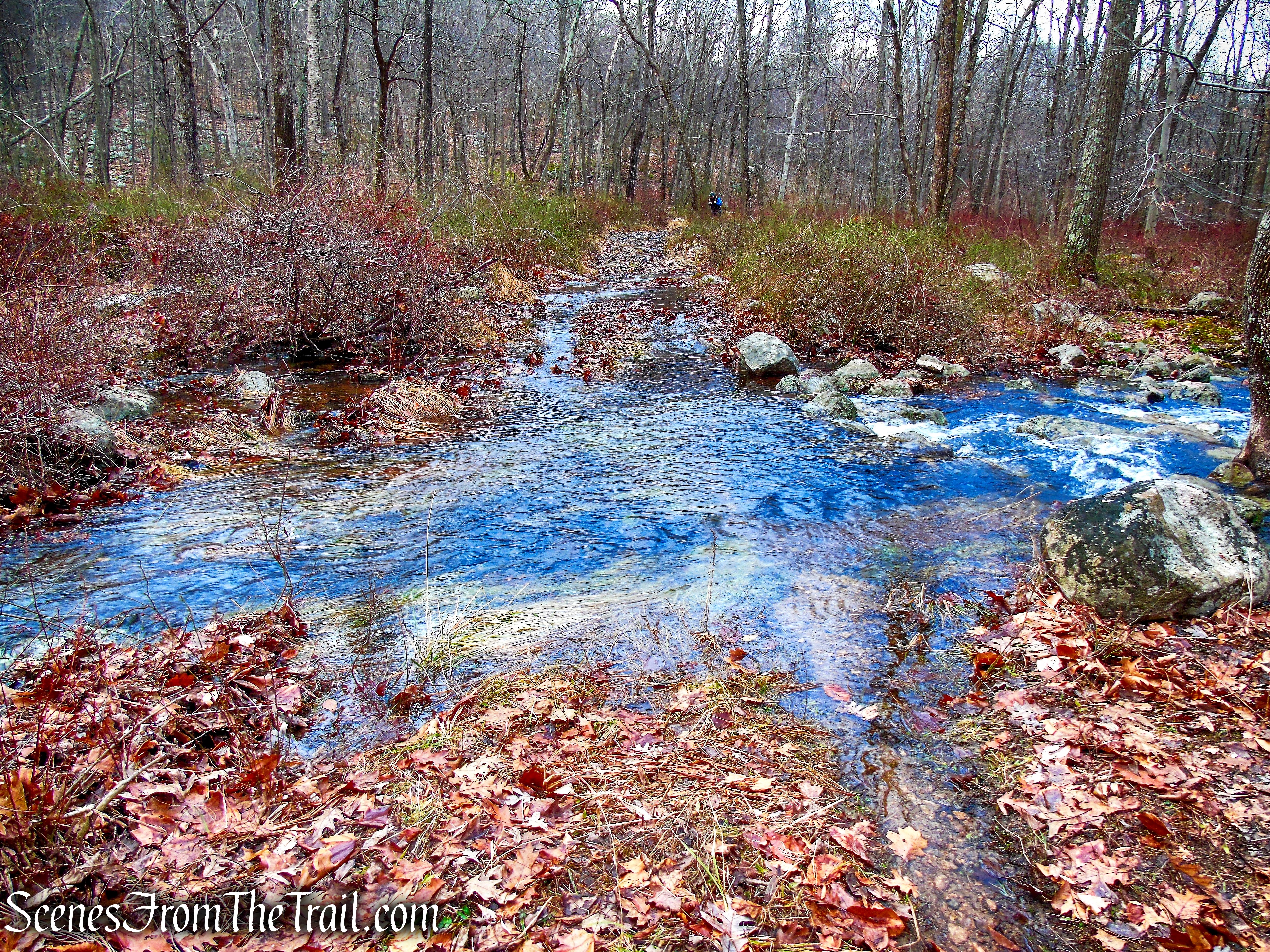
Spring Brook Trail – 2018
After crossing Spring Brook and working through the muddy stretch, the trail opens onto a more typical old woods road.

Springbrook Trail – Harriman State Park

Springbrook Trail – Harriman State Park
The Spring Brook Trail ends at a junction with the White Bar Trail. Turn right and follow the woods road southwest. From here, the White Bar Trail runs parallel to Seven Lakes Drive, and traffic noise may be noticeable along this stretch.

Turn right on White Bar Trail
White Bar Trail – Harriman State Park

White Bar Trail – Harriman State Park

White Bar Trail – Harriman State Park
Follow the horizontal white-bar blazes for about 0.6 mile to return to the trailhead at the Johnsontown Circle Hiker Parking Area. Along the way, the white-blazed Kakiat Trail joins from the left and, a short distance later, branches off to the right. Both trails use white blazes, but the Kakiat Trail is marked with vertical blazes, while the White Bar Trail uses horizontal bars. Just continue straight, following the horizontal blazes, and you’ll stay on the correct trail.

White Bar Trail – Harriman State Park

White Bar Trail – Harriman State Park
Not far from the trailhead, a large pile of bear scat provides a reminder that you’re not the only one using the White Bar Trail.

White Bar Trail – Harriman State Park

White Bar Trail – Harriman State Park

Terminus of White Bar Trail
Review:
This is an excellent moderate hike in Harriman State Park that packs an impressive variety of scenery, history, and unique natural features into 4.3 miles. The route passes several fascinating points of interest, including Almost Perpendicular, Claudius Smith Rock and Den, and Elbow Brush, along with numerous other striking rock formations and massive boulders that make the hike especially memorable.
The well-marked and maintained trails wind through an ever-changing landscape, from rocky ridges and steep climbs to quieter valleys and stream crossings. There are several ascents that add a bit of challenge, but hikers are rewarded with great views and plenty of interesting terrain along the way. The constant changes in scenery help keep the hike engaging from beginning to end.
With its combination of unusual rock formations, local history, scenic views, and varied terrain, this loop offers much more than the typical walk in the woods. It is a great choice for hikers looking for a moderately challenging route that showcases some of the diverse and rugged beauty Harriman State Park has to offer.
Pros:
Scenic views, fascinating rock formations, Almost Perpendicular, Claudius Smith Rock and Den, Elbow Brush, well-marked trails, varied terrain, interesting history, moderate challenge, secluded sections.
Cons:
Some road noise along the White Bar Trail, junction of the TMI and Blue Disc Trails can be confusing.
Take a hike!

Almost Perpendicular & Claudius Smith Rock Loop
Sources:
- Harriman State Park
- The Legend of Claudius Smith
- Claudius Smith, “Cowboy of the Ramapos,” hangs
- Terror in the Ramapos
- Myles, William J.; Chazin, Daniel. Harriman Trails: A Guide and History . New York – New Jersey Trail Conference. Kindle Edition.

