April 17, 2018 – Cortlandt, NY
Difficulty: Strenuous
Length: Approximately 4.3 miles
Max elevation: 910 ft. – total elevation gain: approximately 1,333 ft.
Route type: point-to-point/shuttle
Map: East Hudson Trails Map #101
Trailhead parking: Bear Mountain Tollhouse 28 Bear Mountain Bridge Rd, Cortlandt, NY 10567
The Camp Smith Trail is approximately 3.7 miles long and extends from the Historic Toll House (Visitor Center) on Route 6-202 to the Appalachian Trail (AT) on Anthony’s Nose. As described by the New York-New Jersey Trail Conference: “Without a doubt, the most rugged trail in Westchester County is the Camp Smith Trail, which rewards a hiker with many panoramic views along its route.” Camp Smith (military reservation) is about 50 feet to the right of the trail in most places on the way to Anthony’s Nose. It is heavily used by the military and may include live gunfire. Many places to the left of the trail, there are steep cliffs that drop down to Bear Mountain Road.

Camp Smith Trail
Anthony’s Nose is a peak along the Hudson River at the north end of Westchester County, New York. Together with Dunderberg Mountain, it comprises the South Gate of the Hudson Highlands. The 910 ft. peak has been known as Anthony’s Nose since at least 1697, when the name appears on a grant patent. Pierre Van Cortlandt, who owned this mountain, said it was named for a pre-Revolutionary War sea captain, Anthony Hogan. This captain was reputed to have a Cyrano de Bergerac type nose.
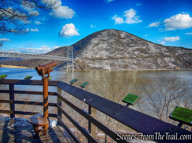
Anthony’s Nose from the overlook – Trailside Museums and Zoo
Anthony’s Nose is one of the more popular hikes in the Hudson Valley and on weekends the cars are lined up along Route 9D as a testament to its popularity. I have wanted to do this hike for quite some time, but I consider this a weekday hike in order to minimize the crowds. With that being said, I chose this as my birthday hike. Having lived in Westchester County for most of my life, it was fitting that I hike the Camp Smith Trail. My intention was to hike it from the Historic Toll House to Anthony’s Nose and back. A tall order for an old guy like me, but I was going to give it a shot. Another option was hiking it in its entirety and descending on the Appalachian Trail to 9D after stopping at Anthony’s Nose. As it turned out we ended up doing the second option.

Camp Smith Trail – Hudson Highlands State Park Preserve
Check out the Google Earth Fly-Through video of the hike below.
Since I was feeling optimistic, we only used one car. This hike is better done with a car parked at each end. We parked at the historic Bear Mountain Bridge Toll House, 0.7 mile north of the entrance to Camp Smith on Bear Mountain Road, Route 6/202. The Toll House currently serves as the trailhead for the Camp Smith Trail.

Bear Mountain Bridge Toll House
The Toll House and Bear Mountain Road were constructed between 1923 and 1924 to connect the newly constructed Bear Mountain Bridge with Route 9. The Road and Bridge were privately owned and tolls for such were collected at the Bear Mountain Road Toll House and at the Bridge itself.
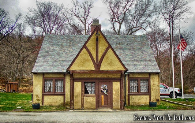
Bear Mountain Bridge Toll House
The one-story Tudor-style Toll House has a gabled slate roof, exposed timbers, and smooth stucco finish. The west bay of the Toll House housed the office and collection area for tolls. In 1940, the Bridge and Road were sold to the State of New York. Under ownership of the State, collection of tolls for the Road ceased and the Bear Mountain Road Toll House was essentially left vacant. Restored in 2002, the Toll House is now used as a Tourist Information and Welcome Center. The Bear Mountain Bridge, Route 6/202 (Bear Mountain Bridge Road) and the Toll House were listed on the National Register of Historic Places in 1982 as part of the Hudson Highlands Multiple Resource listing.

Bear Mountain Bridge Toll House
Since there was rain in the forecast for the afternoon, we decided to get an early jump and arrived at approximately 8:15 am. It was in the high 30’s and windy when we began the hike and rose to the mid 40’s throughout the day. The blue-blazed Camp Smith Trail starts behind the historic Bear Mountain Bridge Toll House.

Start of Camp Smith Trail
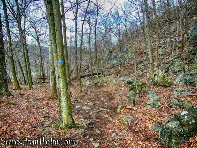
The triple blazes, which signify the start of the trail, are visible on a tree just past the brown shed on the right. We would be following the blue blazes until its terminus at the Appalachian Trail.

blue-blazed Camp Smith Trail
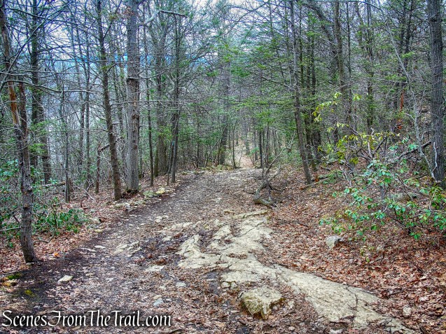
At first, the trail parallels the road, climbing steadily.

Camp Smith Trail
There are numerous signs alongside the trail, which borders Camp Smith. Camp Smith is a military installation of the New York Army National Guard and consists of 1,900 acres.

Camp Smith Trail
The trail travels past large boulders and rock formations as it ascends Manitou Mountain.

Camp Smith Trail
It drops steeply through a rock field and turns left before reaching a massive cliff.

Camp Smith Trail
Staying within sight and sound of the road, it works its way gradually uphill, crossing small ridges.
Camp Smith Trail
At 0.6 mile, it begins a serious ascent of Manitou Mountain.

Camp Smith Trail
It then soon climbs very steeply on a series of rock steps.

Camp Smith Trail
The trail continues to climb over jumbled rocks.

Camp Smith Trail
It turns left to reach a viewpoint to the south.

southern viewpoint – Camp Smith Trail

southern viewpoint – Camp Smith Trail
Turning right, it crosses the top of an open rock face.

Camp Smith Trail

open rock face – Camp Smith Trail
The Camp Smith Trail drops slightly and resumes its steady ascent of Manitou Mountain.

Camp Smith Trail
It passes through a gully as it approaches viewpoints on the brow of the mountain. At 0.9 mile, we stopped for a few minutes to enjoy the view of Iona Island with West Mountain in the background. In 1899, Iona Island was bought by the U.S. Navy for use as a naval ammunition depot, becoming one of the largest ammunition facilities in the nation, at that time. The depot supplied much of the munitions for both World War I and II, and remained in service until 1947.

Iona Island – Camp Smith Trail
The island was bought by the Palisades Interstate Park Commission in 1965. In 1974 it was named a National Natural Landmark by the National Park Service. As an active wildlife sanctuary, Iona Island is currently closed to the public.

Iona Island – Camp Smith Trail
Approximately five of the original 164 arsenal buildings remain, which the park now uses for storage.

Iona Island – Camp Smith Trail
The trail turns away from the river and then left again toward a rock outcropping with views. To the north, Bear Mountain is visible on the left and Anthony’s Nose on the right, with the Bear Mountain Bridge in the center.

view north – Camp Smith Trail
The Camp Smith Trail then turns right and away from the views to begin its descent. The rock steps, switchbacks, and sidehill construction make it possible to safely descend the extremely steep talus slope. At the base of the descent I took quite a tumble. I rolled my ankle and smashed my shin on a rock. For a few seconds I thought that my hike was done. I cleaned off the wound, applied a bandage and hobbled off to continue the hike.

wounded knee – Camp Smith Trail
At 1.2 miles, the Camp Smith Trail reaches the bottom of the slope, crosses a flat area, turns gradually left, and arrives at a small rock outcropping with a view. From the viewpoint, the trail leads inland and then turns once again towards the river for another view to the west. Leaving the view, the trail continues the gradual descent, crossing intermittent brooks.

Camp Smith Trail
At 1.9 miles, it reaches a parking area on Route 6/202 at a large bend in the road, 2.2 miles north of the entrance to Camp Smith.

Camp Smith Trail
Continuing north to Anthony’s Nose, the trail crosses Broccy Creek and heads gradually uphill, parallel to the road.
Broccy Creek – Camp Smith Trail
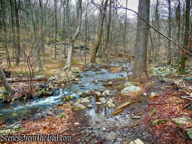
After turning away from the road, it joins and leaves woods roads and crosses streams.

woods road – Camp Smith Trail

stream – Camp Smith Trail
Rising out of a ravine, the trail turns right at 2.4 miles, onto a rock outcropping with views of the Hudson River, Iona Island, and Bear Mountain-Harriman State Park.

Camp Smith Trail

view of Iona Island – Camp Smith Trail

view of Bear Mountain – Camp Smith Trail
Paralleling the river high over the road, the trail first drops slightly then begins to climb steeply.

Camp Smith Trail

Camp Smith Trail
At 2.7 miles, another rock outcropping with a view offers an excuse to stop before tackling the remaining unrelenting assault up Anthony’s Nose.

Camp Smith Trail
Along the last 0.4 mile, there are both seasonal and year-round views from open rock slabs.

turning around and looking south from the Camp Smith Trail
The trail drops down off the summit to join a woods road. Following it straight ahead leads to Anthony’s Nose and panoramic views of the Hudson River, Bear Mountain-Harriman State Park, Hessian Lake and the Bear Mountain Bridge.

Hudson River, Bear Mountain and Hessian Lake from Anthony’s Nose

Bear Mountain Bridge from Anthony’s Nose
Looking southwest, a view of Iona Island from Anthony’s Nose.

Iona Island from Anthony’s Nose
We stopped here for a while, but it was very windy so we took refuge away from the views. There was not a single soul in sight as we sat there and that was just fine by me. At this point my ankle was swollen and my shin was throbbing from the spill I took earlier. Not having another car parked nearby was a dilemma. I didn’t have it in me to retrace my steps back the way we came so it was either a dangerous road walk back to the car along Route 6/202 or call for a ride. Luckily, we called a friend who happened to be driving nearby and he agreed to pick us up at the trailhead on Route 9D. We then followed the blue blazes, which travels on a woods road, to the Appalachian Trail, where the Camp Smith Trail ends at 3.7 miles.
Camp Smith Trail
We then followed the white blazes to the left where the AT descends steeply for 0.6 mile to Route 9D. We then met up with our ride and he dropped us off back at the Toll House.
Pros: Scenic views, great weekday hike, rugged trail, numerous stream crossings, well blazed trail, Hudson River, Anthony’s Nose.
Cons: Need two cars, I fell.
Take a hike!

Camp Smith Trail
Sources:

Good evening,
Not sure if this is the correct way to reach you. I have been enjoying your posts ever since you wrote about the Old Croton Aqueduct Trail. In the meantime since I am hosting a trail improvement event on May 5 on the Aqueduct Trail as part of the NY Statewide I Love My Park Day, it occurred to me to ask you if you would like to branch out and photograph our event. I will attach a flyer and also share a link on our website to give you an idea of what we are up to. http://aqueduct.org/invasive-plants-old-croton-aqueduct If you click on any of the numbered items you will see blogs and photo albums.
Maybe this will not be your cup of tea, but I figured it would not hurt to ask. Feel free to email or call if you have any questions.
Best regards and happy hiking,
Diane Alden
Friends of the Old Croton Aqueduct
(914) 941-8536
LikeLike