February 17, 2018 – Woodbury, NY
Difficulty: Moderate
Length: Approximately 6 miles
Max elevation: 1,200 ft.– total elevation gain approximately 898 ft.
Route type: Lollipop Loop
Map: Harriman-Bear Mountain Trails Map #119
Trailhead parking: Silver Mine Picnic Area, Woodbury, NY 10980
This hike was originally slated for Sunday, but I rescheduled it to a day earlier in order to beat the snow. Since this hike consists of unmarked roads and some bushwacking it is best done when the leaves are off the trees. I visited Cranberry Mine a year earlier and decided to incorporate it into a longer loop hike and search for an obscure mine that sits hidden among the cliffs of Black Mountain.

Cranberry Mine and Black Mountain Loop
Check out the Google Earth Fly-Through video of the hike below.
We parked at the Silver Mine Picnic Area on Seven Lakes Drive. There are plenty of parking spots available there and access to several trails as well.

Silver Mine Picnic Area
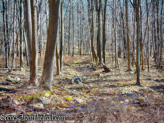
Once parked and geared up, we crossed Seven Lakes Drive and headed for the sign just across the road. Just beyond the sign, there is an old woods road that parallels Seven Lakes Drive. We turned right and began heading east along this road.

old woods road
The road gradually ascends then levels off as it veers north. This road was lined with telephone poles, which gave me the impression that at one time it was a main road, possibly used for transporting mining materials. This road is not maintained by the park and it appeared to be seldom traveled. It was swampy in some sections.

old woods road
After approximately 0.7 miles, we arrived at a stream that flows from north to south. This stream flows downhill, under Seven Lakes Drive and into Queensboro Brook. Here we turned left and began bushwacking north along the western side of the stream.

bushwacking north along the western side of the stream
It is a relatively easy 0.3 mile bushwack, although there are numerous downed trees and barberry bushes along the way.

bushwacking north along the western side of the stream
In a short distance, there is a woods road that runs from east to west and crosses the stream. We turned left (west) onto this road and walked uphill towards Cranberry Mine.

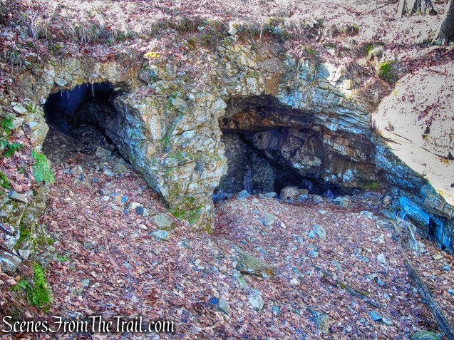
Cranberry Mine
In the late 19th and early 20th centuries, extensive iron mining and exploration activity took place along the southeast side of Cranberry Hill in present-day Woodbury Township, New York.
Lenik, Edward J.. Iron Mine Trails (Kindle Locations 1568-1569). New York – New Jersey Trail Conference. Kindle Edition.

Cranberry Mine
The principal feature of this complex is a horizontal shaft that extends into the hillside for about 200 feet. This mine opening or adit is twenty-two feet wide and about twelve feet high, while the interior shaft is twelve feet wide.
Cranberry Mine
A cut stone wall, bonded with cement and containing an iron plate door, was built across the entrance to the mine around 1920. The mine was used to store dynamite by park officials until the 1930’s. The iron door at the mine entrance has been torn open.

Cranberry Mine
The iron door has been replaced with a bat gate. Due to declining bat populations over the years, caused by a disease known as WNS or White Nose Syndrome, some mines have been closed to visitors during hibernating months.

Cranberry Mine
There is a powder storage magazine which is located about 350 feet north of the mine shaft entrance. This former magazine is a banked earth-covered structure with interior dry-laid stone walls, a stone front with an iron door, and a domed corrugated metal roof. The interior chamber measures fourteen feet in length and five feet in width. This powder magazine was built and used for powder storage during the period of mining activity and later was adapted for dynamite storage by the park.

powder storage magazine
When we were ready to move on, we debated whether we should bushwack back down the hill the way we came or venture down the old woods road that leads east from the mine. Not knowing the condition of the road or if it was even passable, led to some apprehension, but in the end, we chose the woods road.
woods road
This woods road was very swampy soon after crossing the stream, but then cleared up. Surprisingly, it is easy to follow and except for a few blowdowns across the road, is quite clear for an old unmaintained road.

old woods road
The road veers southeast and approaches Seven Lakes Drive. A huge blowdown blocked the road so we bushwacked to the right and came to the continuation of the woods road where we began our hike. We then bushwacked a short distance out to Seven Lakes Drive.

Seven Lakes Drive just ahead
We then walked along Seven Lakes Drive for about 300 yards until we came to Silvermine Road, marked by a cable hung between two boulders on the south side of the road.

Silvermine Road
Silvermine Road heads south towards Queensboro Brook then turns right and skirts the edge of the brook. It then veers to the left and crosses Queensboro Brook on a wooden bridge.
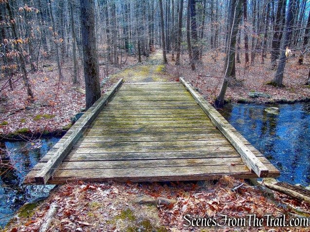
Silvermine Road

Queensboro Brook
This woods road was built in 1934 by workers of the Temporary Emergency Relief Administration. The road begins a steady climb and then levels off as it travels between Black Mountain and Silver Mine Lake.

Silvermine Road
There ARE many places along the lake to take a break and have a snack, and we did just that.

Silver Mine Lake
Silvermine Road then climbs again and reaches an intersection with the joint Appalachian and Ramapo-Dunderberg Trails, at the notch between Black Mountain and Letterrock Mountain. We turned left (east) on the joint AT/R-D trail, which climbs steeply to Black Mountain.

joint AT/R-D trail
The climb is rather steep, but short lived. This was the toughest part of the hike, but doable by most hikers.

joint AT/R-D trail
After a short climb, the trail comes out to a rock ledge with a great western view of Silver Mine Lake and the Harriman Hills.

western view from Black Mountain
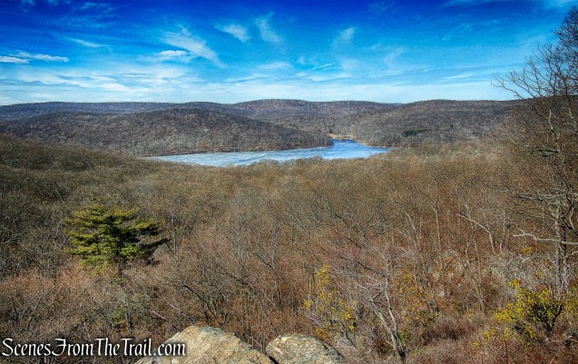
western view from Black Mountain
We took a break here to enjoy the view, but we weren’t quite at the summit yet. We had about 100 vertical feet and about 500 yards to go. The trail is rather steep in spots and requires slight scrambling, but nothing too difficult.

joint AT/R-D trail on Black Mountain
The trail levels off and continues southeast along the edge of the cliffs.

joint AT/R-D trail on Black Mountain
Continuing along the ridge, the Hudson River comes into view.

view of the Hudson River from Black Mountain
We made it to the 1200 ft. summit and just beyond, where we sat and rested while enjoying the view. Looking southeast, the Palisades Parkway is visible below and the Hudson River in the distance.

view of the Hudson River from Black Mountain
We then began retracing our steps along the ridge and in search of the Silver Mine. I wasn’t exactly sure of its location, but I had an idea of the general vicinity. The Spanish Mine sits atop the mountain and consists of two shallow pits which are not very impressive. The mine that I was looking for is more intriguing.
Facts regarding the ownership and operation of this mine, also known as the Spanish Silver Mine or the Silver Mine, are lacking, but mystery and legend abound. It was the reported burial place of Captain Kidd’s treasure. Another legend, attributed to R.H. Torrey, a founder of the New York-New Jersey Trail Conference, states that the mine was dug by Spanish miners in the 18th century.
Lenik, Edward J.. Iron Mine Trails (Kindle Locations 1653-1654). New York – New Jersey Trail Conference. Kindle Edition.
Where the trail descends steeply for about twenty vertical feet, we turned left, leaving the trail, and continued in an easterly direction around the face of the cliff. The mine shaft is located about 100 vertical feet below the summit and the footing can be quite treacherous in this area. I climbed down the steep slope with hopes of finding the mine. I could have used some hiking poles in this area as I kept sliding. Since I wasn’t quite sure if I was even in the right area, I decided to give up. I did not want to continue as I was wearing down a bit and the climb back up to the trail was not easy. While doing more research, post hike, I found the possible GPS location of the elusive mine and according to the coordinates, I came within 50 feet of it. I won’t be satisfied until I can find it.
After huffing and puffing back up to the joint AT/R-D, we retraced our steps back to Silvermine Road and turned right, heading north, back to Seven Lakes Drive. We turned left on Seven Lakes Drive and walked 0.4 miles back to the Silver Mine Picnic Area, where the hike began.
This is a nice moderate hike that incorporates a lot of the things I love about Harriman State Park. I highly recommend this hike to everyone.
Pros: Cranberry Mine, seldom used woods roads, not much foot traffic, Silver Mine Lake, scenic views, Appalachian Trail.
Cons: I didn’t find Spanish Silver Mine.
Now get out there and take a hike!

Black Mountain

This looks like an awesome hike!!! hurry up warm weather 🙂 – thanks for the super post!
LikeLiked by 1 person