October 22, 2017 – Gardiner, NY
Difficulty: Moderate to strenuous
Length: Approximately 8 miles
Max elevation: 1,291 ft.– total elevation gain approximately 896 ft.
Route type: Circuit
Map: Shawangunk Trails – Mohonk Mountain House web map
Fee: $15.00 day hiking fee – West Trapps Trailhead
Trailhead parking: Mohonk Preserve West Trapps Trailhead Parking Area 3142 US-44, Gardiner, NY 12525
The Mohonk Mountain House property consists of 1,325 acres, and much of it is landscaped with meadows and gardens. It adjoins the Mohonk Preserve, which is crisscrossed by 85 miles of hiking trails and carriage roads. The Mohonk Mountain House charges $22.00 Monday-Friday and $27.00 weekends/holidays for a day hiking pass. A hiking pass does not include access to the interior of the house or lake swimming. The Mohonk Preserve (non-profit nature preserve) and the Mohonk Mountain House (resort hotel) are two separate places. The Mohonk Preserve charges $15.00 for a day pass (annual memberships available) which also allows access to the Mohonk Mountain House property. The only drawback is that you have to hike a couple of miles in order to get to the Mountain House grounds. That normally adds five miles to any hike unless you pay to park on their property.

Giant’s Workshop from West Trapps Trailhead – Mohonk Mountain House
Check out the Google Earth Fly-Through video of the hike below.
Mohonk is famous for its Lemon Squeeze, which lies within the Labyrinth rock scramble. There are other notable hikes that involve rock scrambles, agility, and the use of hands as well as feet, including Arching Rocks Path, Cathedral Path, Giant’s Path, Humpty Dumpty Path and Rock Rift Crevices. Our intention was to hit the spots that were clustered together. This hike covers Giant’s Path, Humpty Dumpty Path and the Cathedral Path.

Mohonk Mountain House rock scrambles
We arrived at the West Trapps Trailhead parking area at 8:50 am and the lot was already at capacity. We were lucky to find a spot after circling the lot. This parking lot fills VERY early on peak weekends.

West Trapps Trailhead Parking Area
We grabbed our gear and headed towards the northeastern end of the parking area to begin our hike on the yellow-blazed West Trapps Connector Trail.

West Trapps Connector Trail
After a short, easy walk of 0.4 miles, the trail arrives at the junction for Undercliff and Overcliff Roads.

junction for Undercliff and Overcliff Roads
Overcliff Road would be our return route, we stayed right and took Undercliff Road. Either way will bring you to the same spot as the two roads form a five mile loop.

Follow Undercliff Road
Undercliff Road makes for any easy walk, with its crushed stone surface.

Undercliff Road
This loop road was first built in 1903 so that guests at the Mohonk Mountain House could take carriage rides and enjoy the views. Looking southeast, splendid views of the Wallkill Valley can be seen.
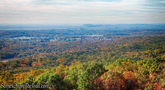
View of the Wallkill Valley – Undercliff Road
Undercliff Road passes alongside the Trapps Cliff, which is usually filled with rock climbers.

Undercliff Road
The Gunks has some of the best rock climbing in the world.

Undercliff Road
Walking along the road with never ending views on a gorgeous Sunday morning, was the start of a great hike. Looking northeast, Skytop Tower, built in 1921, can be seen in the distance.

Skytop Tower – Mohonk Mountain House
After approximately 2.5 miles from the start of the hike, we came to the intersection of Undercliff/Overcliff Roads, and Laurel Ledge, with the Rhododendron Bridge on the right. I did not see a rhododendron anywhere.

Intersection of Undercliff/Overcliff Roads, and Laurel Ledge
We continued straight ahead on Laurel Ledge Road.

Laurel Ledge Road
We stayed on Laurel Ledge Road for about 0.4 miles. Just past the junction with the Old Minnewaska Trail, We turned right onto the blue-blazed Giant’s Path.

Giant’s Path
This turn can be easily missed if you’re not paying attention. The sign is about 15 feet off the trail and not easily visible from Laurel Ledge Road.

Giant’s Path
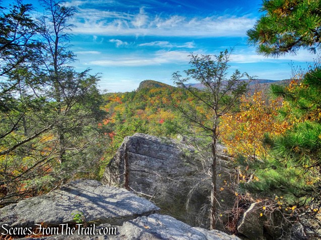
Giant’s Path leads to the base of the Giant’s Workshop, a rock scramble over and under boulders and through narrow rock crevasses, that climbs Eagle Cliff.

Giant’s Workshop
It is similar to the Labyrinth and Lemon Squeeze, but on a smaller scale.

Giant’s Workshop
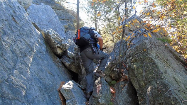
It was a tight squeeze in several spots and we had to remove our backpacks in order to fit through. Sadly, I had my camera packed away during most of the scramble, but did capture an image looking down after we emerged on a rock ledge.

Giant’s Workshop
The view from the rock ledge as we came out of the Giant’s Workshop.
View from the top of Giant’s Workshop
After a brief rest, we continued to ascend Eagle Cliff on Giant’s Path. In a few hundred feet, we turned right on the Humpty Dumpty Path and began another rock scramble.

Humpty Dumpty Path
This trail, although it gains elevation, is more of a horizontal scramble. Similar to Giant Stairs in the Palisades, but not nearly as long.

Humpty Dumpty Path
Once again, having to use both my hands and feet to traverse this trail, I only captured a few images. This trail has got to be hiked to be appreciated.

Humpty Dumpty Path
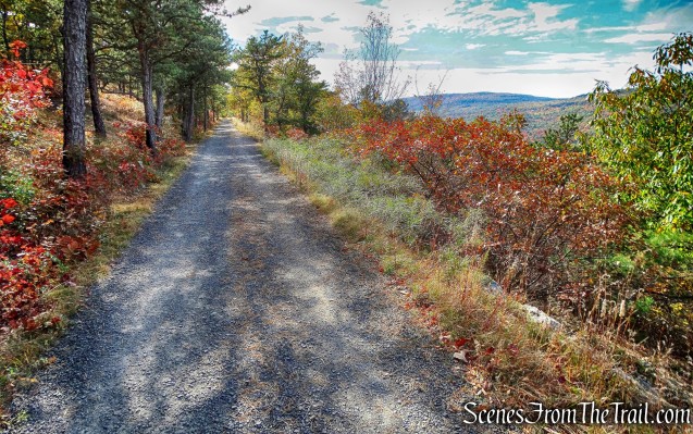
The Humpty Dumpty Path ends at Humpty Dumpty Road, a carriage road on the shoulder of Eagle Cliff. It provides a fantastic view of The Trapps Cliffs. We began our hike on Undercliff Road at the base of those cliffs..

Humpty Dumpty Road
The area below the level of Humpty Dumpty Road is part of the Mohonk Preserve, we were now on Mohonk Mountain House property. Humpty Dumpty Road snakes its way up the mountain…….

Humpty Dumpty Road
with the imposing cliffs to the right of the road.

Cliffs along Humpty Dumpty Road
In about 0.3 miles, Humpty Dumpty Road arrives at a junction with the Cathedral Path. Right next to the junction is a wooden gazebo with great views.

Humpty Dumpty Road
We descended down Cathedral Path and over to Cope’s Lookout. It is supposed to be one of the best views at the Mohonk Mountain House property, I would have to agree.

Cope’s Lookout
Looking northwest, the Catskill Mountains are visible in the distance.

View northwest from Cope’s Lookout
We sat here and enjoyed our lunch and the fantastic view that we earned.

Cope’s Lookout
We then continued on Cathedral Path as it descends the mountain. A steep rock scramble that was challenging, but lots of fun.

Cathedral Path
As challenging as this trail is going down, it must be a lot tougher to ascend. I look forward to trying it some time.

Cathedral Path
Below is an image looking back after descending.

Cathedral Path
We veered off the Cathedral Path briefly onto Arching Rocks Path to take another brief rest under the Arching Rocks.

Arching Rocks Path
We then jumped back on the Cathedral Path and took it to its terminus at Plateau Path. There we turned right and took Plateau Path until its terminus at Laurel Ledge Road and turned left.

Laurel Ledge Road
We stayed on Laurel Ledge Road until it comes to the junction at the Rhododendron Bridge. There we turned right and began following Overcliff Road.

Overcliff Road
Overcliff Road climbs gradually as it turns and begins to head southwest.

Overcliff Road
Overcliff Road has numerous views to the west of the Catskill Mountains.

View from Overcliff Road
This was a nice way to end a long hike. Easy walking and views for days.
Overcliff Road

View from Overcliff Road

View from Overcliff Road
Overcliff and Undercliff Roads can be done as a loop by themselves for a very scenic 5 mile hike.

Overcliff Road
The views never seem to end, but I won’t complain.

View from Overcliff Road
We arrived at the junction with Undercliff Road and veered right, walking between the Trapps Bridge and the wooden railing, to the yellow-blazed West Trapps Connector Trail and back to the parking area, where the hike began.

West Trapps Connector Trail
This was one of the better hikes that I have done. I was pretty tired, but it was well worth it. There are more rock scrambles that we did not do, but we had to save energy for the long walk back to the parking area. Next time, stay tuned.
Pros: Rock scrambles, outstanding views, The Gunks, fun and challenging.
Cons: Parking area fills up early.
Take a virtual hike with additional images added below.
Take a hike!
Humpty Dumpty Path – Mohonk Mountain House

I’ve said it before and I’ll say it again. Just book to $40 something breakfast and you can drive up to the house and enjoy the amenities (not spa).. It assures people get there early and you don’t have the extra mileage to hike.. But I’m old. Maybe you guys/gals can handle it..
It’s a great scramble/hike.
LikeLike