September 17, 2017 – Harriman, NY
Difficulty: Easy
Length: Approximately 4.5 miles
Max elevation: 1,008 ft.– total elevation gain approximately 366 ft.
Route type: Lollipop-Loop (sort of)
Map: Harriman-Bear Mountain Trails Map #119
Trailhead parking: 627-633 Long Mountain Pkwy, Harriman, NY 10926
Originally this hike was supposed to be part of Brooks Hollow Bushwack, which was done a couple weeks earlier. I Decided to make it a separate hike in order to fully wander through the area. As it turned out, it was more of an exploration rather than a hike. An easy walk in the woods in a section of Harriman State Park that doesn’t get a lot of foot traffic. In fact, we didn’t encounter anyone while we were wandering the area. There are summer camps that are still in operation here from June to Labor Day and this area should be avoided during that time.

trailhead parking
The parking area is easy to miss, even if you are looking for it. The small brown sign (above) and the almost hidden paved road (below), are the only indications that a parking area even exists.

parking area
Baileytown Road begins as a paved camp road, starting from Long Mountain Parkway (US 6) and passing between Lake Te Ata and Lower Twin Lake. After 2.1 miles, Baileytown Road ends at the gated entrance to the Harriman estate. Baileytown Road actually continues for 4.5 more miles through the Harriman estate to Arden, which is off limits to hikers. There aren’t any official marked trails in this section of the park, just paved and woods roads.

Three Lakes via Baileytown Road
After leaving the parking area between Barnes Lake and Lake Massawippa, we walked east alongside Long Mountain Parkway (US 6). Cars were whipping by at 9:20 am, but the shoulder is wide enough to walk it safely.

walking east on Long Mountain Parkway
When we got to Lake Massawippa, we crossed the road in order to capture an image of a foggy Lake Te Ata from the side of the road.

Lake Te Ata
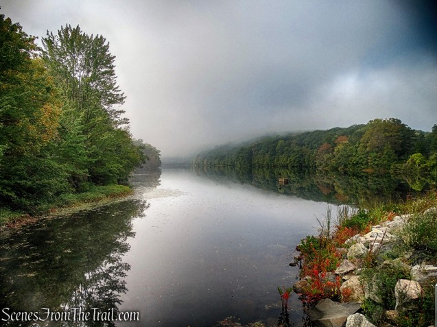
Lake Te Ata
Just past Lake Te Ata, is Baileytown Road, where we turned right. The sign shows the names of the camps that operate here during the summer.

right on Baileytown Road
We began walking up Baileytown Road which rises gently.

Baileytown Road
In a short distance, we came to a fork in the road. Baileytown Road continues ahead, but we took the left fork to check out the camps.
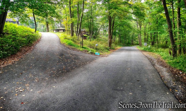
left at the fork
The first camp we came to is Camp Wakonda, which serves children who live in New York City’s homeless family shelter system. The camps were pretty much boarded up for the winter.

Camp Wakonda
Walking southeast towards Lower Twin Lake, we passed Camp Manitou, which has served underprivileged girls since 1936. The Twin Lakes region, one of the camping centers along the northwestern border of the Park, devoted to girls camps and known as “No Man’s Land.” I happen to find a newspaper article from 1927 that talks about the camps.

Camp Manitou
Lower Twin Lake is a natural body of water that was enlarged somewhat by a dam that was built around 1850. In 1918, the park acquired the lake.

Lower Twin Lake
We weren’t following the map, just sort of wandering around and checking things out. When we were done at Lower Twin Lake, we headed west on a woods road back to Baileytown Road.

heading west towards Baileytown Road
Now walking south on Baileytown Road, we had Lower Twin Lake on our left and Lake Te Ata on our right. Lake Te Ata although visible through the trees, I didn’t see any spur trails that led towards open views. We passed a pump house on our left and then a stone arch that carries the pipes over an outlet of Lower Twin Lake.

stone arch
These pipes feed water to the different camps around the lakes.

water pipes
We came to another fork in the road with a sign for the Twin Lakes Regional Museum.

Twin Lakes Regional Museum
Instituted in 1919 by Benjamin “Uncle Bennie” Babbit Talbot Hyde, there was once five such museums scattered throughout the park. It had live animal and other outdoor educational exhibits for the benefit of the campers that were mostly from the inner-city. This stone building, now empty and boarded up, once housed the museum for the Twin Lakes region. It was constructed by the Works Progress Administration in the late 1920’s.

Twin Lakes Regional Museum
We walked back down to Baileytown Road and continued heading southwest through another camp.

Mosholu Explorers Camp
We made our way to Upper Twin Lake by walking down a wooden staircase.
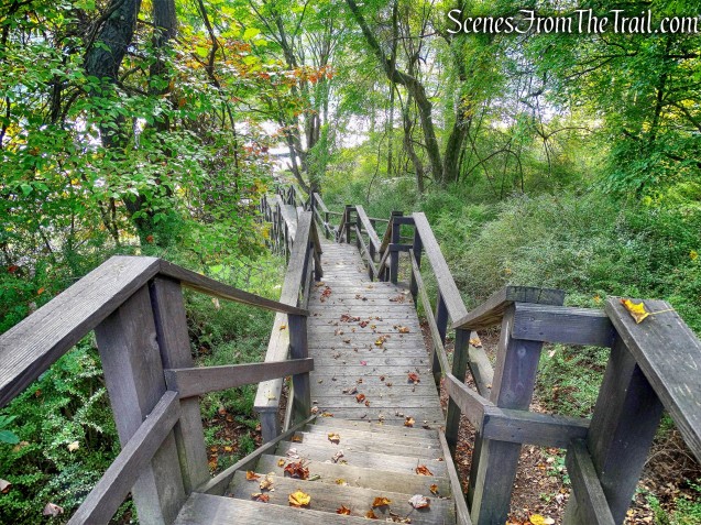
wooden staircase
At the bottom of the stairs there is a huge aluminum dock. There is a picnic table there which we took full advantage of.

aluminum dock
After a short while of enjoying the lake breeze, we continued on our way along a woods road that parallels the lake.

woods road
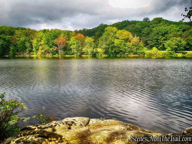
We followed the woods road until it came to a paved road and turned right. We came to the YMCA’s Camp Discovery and turned right again, heading towards the northern end of Upper Twin Lake. This is the best spot to get a good view of the lake.

Upper Twin Lake
In 1919, the Park purchased Upper Twin Lake and the 30 acres around its shore. The region around Upper Twin Lake was called Baileytown. In 1930, when the Park acquired the last Bailey properties, the family was permitted to remain in their homes for the rest of their lives.
Myles, William J.. Harriman Trails: A Guide and History (Kindle Locations 5867-5869). New York – New Jersey Trail Conference. Kindle Edition.

Upper Twin Lake
We began heading southeast on a woods road, crossing a footbridge and then the road ended. I saw a faint footpath heading up the hill, so we took it. The unmarked trail rises slightly and passes by an abandoned latrine.

abandoned latrine
The trail then fizzles out so we began to bushwack northeast. My plan was to bushwack to the eastern side of Lower Twin Lake, but I was overruled. The bushwacking wasn’t too bad, it was mostly through lowbush bluberry.

bushwacking northeast
We came out on Baileytown Road and turned left. We followed the paved road for a short distance then turned right onto a woods road which led to the southern end of Lower Twin Lake.

Lower Twin Lake
We continued on a dirt road, heading northwest and passing several cabins.

woods road
We eventually ended back on Baileytown Road and found a faint spur trail that leads to a nice viewpoint from a rock outcrop over Lake Te Ata.
Lake Te Ata
We walked to the end of Baileytown Road and turned left on Long Mountain Parkway (US 6). The best view of Lake Te Ata is from the side of the road. Te Ata, which in the Chickasaw language means “bearer of the morning,” or “the dawn,” was built in 1927.

Lake Te Ata
On the evening of July 11, 1932, Eleanor Roosevelt, a frequent visitor to the camps in the park, dedicated Lake Te Ata with a bottle containing water from each of the lakes in the Park.

Lake Te Ata
We made our way back to the parking area where our hike began by crossing US 6, carefully. I was looking to do an easy hike and this fit the bill perfectly. I also got another history lesson as well as some fresh air in the woods. With the exception of some road noise at the beginning, this was a quiet walk in the woods with some scenic lakes and no people. Hope you enjoyed it, I surely did. Now get out there and take a hike!
Pros: Three lakes, secluded area, level woods roads, history lesson.
Cons: Road walk along a busy US 6, some road noise at the start, no marked trails.

Upper Twin Lake

So scenic! Love a hike near a water source – thanks for another great post !
LikeLiked by 1 person
As always, thanks for reading.
LikeLike
I used to go to camp manitou in the 70’s I would love to go see it and hike to the Indian caves
LikeLike
My grandfather was born in Baileytown in 1899. His name was Jacob Lewis. Son of James Lewis. Grandson of William Lewis a Civil War veteran. My family lived in Baileytown for generations. Wish I still owned my family homestead. So peaceful there on the Upper Twin
LikeLiked by 1 person