August 21, 2017 – Highlands, NY
Difficulty: Strenuous (1 steep climb, 1 steep descent and numerous ups and downs)
Length: Approximately 5.8 miles
Max elevation: 942 ft.– total elevation gain approximately 1,343 ft.
Route type: Circuit
Map: Harriman-Bear Mountain Trails Map #119
Trailhead parking: 9W Parking US-9W Highland Falls, NY 10928 (They no longer allow hikers to park at the Fort Montgomery Historic Site. Park here and walk about a 1/4 mile south to the trailhead at Fort Montgomery Historic Site.)
A shorter loop hike to The Torne can be viewed HERE.
Popolopen Torne, officially called “The Torne,” is a small mountain with a relatively sharp and bald peak, part of the Hudson Highlands, with a summit 942 feet above sea level. It is located in Bear Mountain State Park and has 360° views, with the Hudson River and the Bear Mountain Bridge to the east, the hills of the West Point Military Reservation to the west and Bear Mountain to the south.
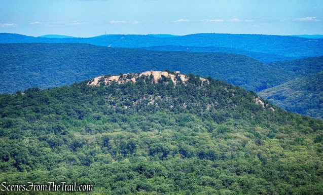
Popolopen Torne as viewed from Long Mountain
Ever since I hiked West Mountain, I have been dying to do this hike. Seeing that bald peak in the distance had me intrigued. Knowing that a memorial for fallen soldiers sits at the summit, was the motivating factor for me to climb ‘The Torne.” Even though it’s a strenuous hike, it’s quite popular so we decided to do this hike on a Monday Morning. The hike was done in a counter-clockwise fashion from the overflow hiker’s lot.

Popolopen Torne – Popolopen Gorge Loop hike route
A new feature that I have added is the Google Earth Fly-Through. It follows the path that we hiked and it gives you a good idea of the terrain, layout, amount of parking etc. Check it out, it’s pretty cool.
View the Google Earth Fly-Through video of the hike below.
Normally the parking for this hike is at the Fort Montgomery Historic Site, but I have heard that they don’t want hikers to park in their lot any longer. On the day of our hike, the gate was closed so we continued about a 1/4 mile north and parked in the overflow lot. The lot was empty when we arrived at approximately 8:45 am.

Overflow parking
It was a cool morning when we embarked on our hike, but ended up being in the mid 80’s and humid. We started out by walking south on Route 9W towards Fort Montgomery.

walking south on Route 9W
We walked the 1/4 mile to Fort Montgomery and turned left onto the entrance ramp.

turn left into Fort Montgomery
Just past the gate on the south side of the entrance road there is a brown post with a yellow arrow, a blue blaze, and 1777W and 1779 blazes. This marks the start of three co-aligned trails: the 1777W and 1779 Trails and the blue-blazed Timp-Torne Trail.

start of the 1777W and 1779 Trails and Timp-Torne Trail
We would be following the three co-aligned trails for approximately the first 1.5 miles from the brown wooden post. Although the three trails run jointly, the blue-blazed Timp-Torne Trail is the trail that goes up to the summit of The Torne, so we paid attention to the blue blazes to insure we didn’t miss our turn. We walked up some stone steps by the brown post and followed the three co-aligned trails as it led us under the Popolopen Bridge (US Route 9W).

under the Popolopen Bridge
After crossing under the bridge, we proceeded up some stone steps and turned left and began heading northwest on the blue-blazed Timp-Torne Trail.

Timp-Torne Trail
The trail then turns left onto paved McCoy Road and passes an interesting looking stone building just to the right of the trail.
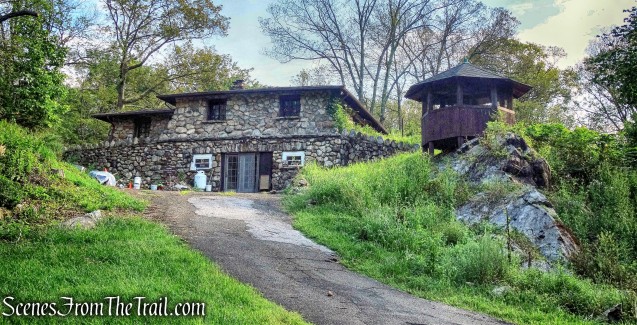
stone building
The trail follows McCoy Road for a short distance and then reenters the woods.

Timp-Torne Trail
In about 0.2 mile, the trail turns left onto the paved Mine Road, but in 125 feet, turns right and leaves the road, marked by blue blazes on boulders by the side of the road.
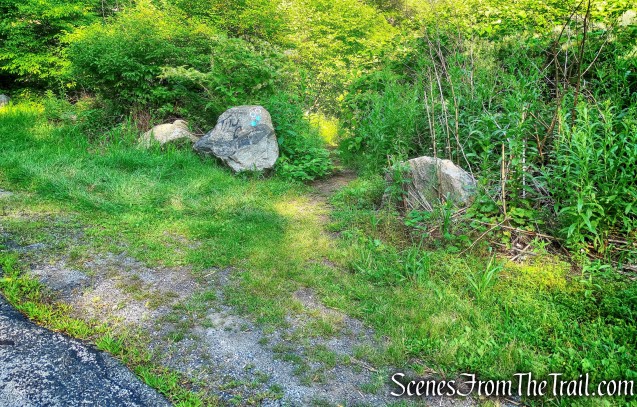
Timp-Torne Trail turns right and leaves Mine Road
In a short distance the Timp-Torne Trail turns left, but I saw a building through the weeds so we continued a short distance ahead to check it out.

building ruins
I don’t know the origin of this building, but it was cool and I’m glad that I spotted it.

building ruins
We retraced our steps back to the turn and crossed a wet area on puncheons, the trail veers left and climbs the hillside.

Timp-Torne Trail
The trail then once again comes out onto the paved Mine Road. We turned right onto Mine Road for about 500 feet. Just past the intersection with Wildwood Ridge, the trail leaves the paved road and reenters the woods.

intersection with Wildwood Ridge
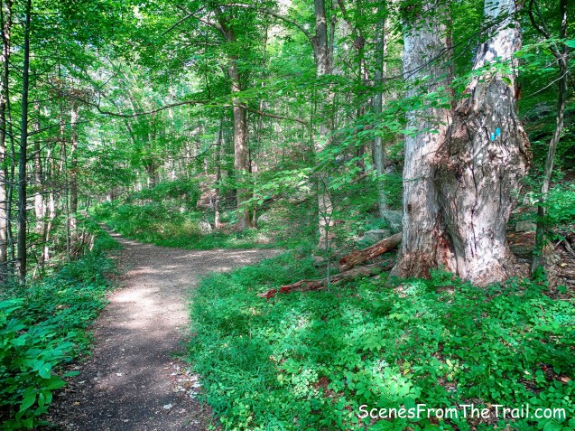
The trail then joins a wide woods road, the route of the West Point Aqueduct which was built in 1906. At first, the route climbs steeply, but it soon descends steeply and then levels off.

Timp-Torne Trail
After about 2/3 of a mile along the West Point Aqueduct, we came to a junction. Here the 1777W and 1779 Trails continue ahead and continue to follow the aqueduct. We made a sharp right, to continue following the blue blazes of the Timp-Torne Trail.
sharp right – Timp-Torne Trail
The Timp-Torne Trail ascends on a woods road and in a short distance reaches paved Mine Road. The trail turns left, follows Mine Road for 100 feet and arrives at a kiosk at the base of Popolopen Torne.
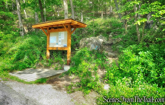
kiosk at the base of Popolopen Torne
Just past the kiosk, there is a wooden sign on a tree. Ouch!

wooden sign on a tree
The Timp-Torne Trail climbs The Torne on stone steps and switchbacks. After a relatively level stretch, the trail turns left and ascends more steeply. It then comes out to a viewpoint over the Hudson River from a rock ledge. We stopped here for a few minutes to catch our breath. There was so much glare, possibly from the impending Solar Eclipse that the few images I captured didn’t come out too good, but trust me, the view is outstanding. Some hikers tend to believe that this is the summit, but it is not. The trail continues along bare rock and then we had to scramble up the last stretch.

scramble – Timp-Torne Trail
We were tired, but we made it to the summit. What a view!

view southeast from Popolopen Torne
No matter how grand the view, the best part of this hike was seeing the memorial for fallen soldiers. The 400 lbs. benches that were placed here, were part of an Eagle Scout project.

Fallen Soldiers Memorial
Greater Love Hath No Man Than To Lay Down His Life For His Brothers.
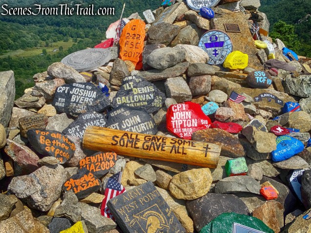
Fallen Soldiers Memorial
Known as the “Trail of the Fallen,” Every rock that has been placed here has been carried up from the base of The Torne. Some as heavy as 200 lbs.

Fallen Soldiers Memorial
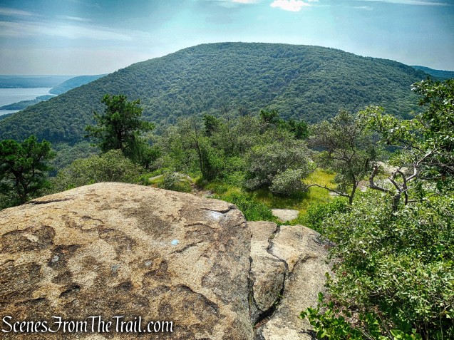
With 360° views, this is now my favorite spot in the Bear Mountain – Harriman area. We found one shady spot and plopped ourselves down and just relaxed while taking in the glorious view. When we first arrived at the summit, there were a pair of hikers there, one of which reads my blog – thank you, I appreciate that. After they left, a lone hiker stopped briefly then went on her way. After that we had the summit and the view all to ourselves.

view south from Popolopen Torne
The view north isn’t bad either.

view north from Popolopen Torne
After spending some time here, it was time to go. The Timp-Torne Trail continues at the southern end of the summit and descends the mountain steeply on rock ledges. We had to use both our hands and feet in some areas as we made our way down.
Timp-Torne Trail – Popolopen Torne
About halfway down, the trail descends more moderately on stone steps and switchbacks. We crossed paved Mine Road and descended to rejoin the 1777W and 1779 Trails at the West Point Aqueduct.

Timp-Torne Trail
We walked along the aqueduct for approximately 250 feet then turned left and descended some stone steps and crossed Popolopen Creek on a 62-foot footbridge. This prefabricated bridge was installed in 2012 by a volunteer trail crew from the New York-New Jersey Trail Conference, replacing a similar bridge that was severely damaged in 2011 by Hurricane Irene.

62-foot footbridge over Popolopen Creek
The creek was very dry on this day, but I’m sure that it is quite scenic when there is water flowing.

Popolopen Creek
On the other side of the bridge, the three co-aligned trails climb the hillside. Here, the Timp-Torne, 1777W and 1779 Trails turn right, but we turned left, now following the red-on-white blazes of the Popolopen Gorge Trail.

Popolopen Gorge Trail
We followed the red blazes of the Popolopen Gorge Trail all the way back to US Route 9W. We were pretty tired by then and all the ups and downs of this trail sure didn’t help. We came out on 9W and crossed the road. We then began our walk back towards the hikers parking lot crossing the Popolopen Bridge on the sidewalk. Now with the sun behind me I was able to capture a decent image of the Bear Mountain Bridge with Anthony’s Nose just beyond.

Bear Mountain Bridge with Anthony’s Nose
When we got back to the lot, it was almost full. It pays to get out and hike early. Even though it was a Monday, I expected to see more people along the trail. We didn’t cross paths with anyone except at the summit. My kind of hike. I hope that you enjoyed this hike and please don’t forget to subscribe to my blog and stay up to date on my wanderings. Now get out there and take a hike!
Pros: Fallen soldiers memorial, views galore, slight rock scrambling, less traveled.
Cons: several short road walks, creek was dry.

at the summit of Popolopen Torne

I missed the trash sign when I hiked this one…………..haha. It’s a great trail.
LikeLiked by 2 people
I like to hike in the dark (with flashlights), but curfews make this difficult in New Jersey. So two favorites of mine closer than the Catskills are Anthony’s Nose and Popolopen Torne.
I’m happy to see they placed a kiosk at the base of Popolopen Torne, because the last time I attempted the short hike from Mine Road, I couldn’t find either the trail or the tiny parking turnout.
LikeLiked by 2 people
Great blog! I discovered it because I was looking for some updates on Popolopen Torne trail.
Do you have any recommendations for a 2-day hike with camp options in NY area? Preferably less popular places… thanks for all the information.
Very helpful with lots of interesting comments.
LikeLike