June 10, 2017 – Stony Point, NY
Difficulty: Strenuous
Length: approximately 7.5 miles
Max elevation: 1,130 ft.– total elevation gain approximately 1400 ft.
Route type: Circuit
Map: Harriman-Bear Mountain Trails Map #119
Trailhead parking: Route 9W – Tomkins Cove, NY 10986
Bald Mountain lies at the end of the northerly ridge of Dunderberg Mountain, which is part of Bear Mountain State Park in the town of Stony Point in Rockland County, NY. A very steep hike to the 1130 ft. summit of Bald Mountain rewards hikers with magnificent views of the Hudson Valley and beyond. Along the way up the mountain, there are remnants of former mining operations visible on the trail along with glacial erratics.
The 1,080-foot summit of The Timp sits on the border of Bear Mountain State Park and Harriman State Park. With its sparsely wooded summit and rock ledges, it offers great views of the surrounding area.
Doodletown survived as a small, isolated community for about 200 years. The area was settled in the 1760s by loggers and miners, and at one time included a church, a school, several small businesses and two cemeteries in addition to 70 houses and 300 residents at its peak in 1945. Doodletown is surrounded by five mountains: Dunderberg, Bald, Timp, West and Bear Mountains.
Originally this hike was going to be a 5 mile hike that included the summit of Bald Mountain and then returning on woods roads through Doodletown. While mapping it out I discovered that The Timp was not too far from the junction where we would turn to descend towards Doodletown. I figured since we would be in the area, why not extend the hike and hit that spot as well. I left it as an option which would depend how we felt after climbing the steep trail to Bald Mountain. I like options when hiking because mileage, elevation and the ruggedness of the terrain are factors one must weigh before heading out on the trail. With that being said, we did the longer version, but it wasn’t easy.

hike route
Check out the Google Earth Fly-Through video of the hike below.
It was a gorgeous Saturday morning which continued throughout the day. Arriving at the parking area just before 9:00 am, there were several vehicles already parked there. We geared up and headed out looking for the blue-blazed Cornell Mine Trail. The hike began just to the left of a concrete bridge which spans Doodletown Brook. Here the blazes are painted on the back of a sign.

Cornell Mine Trail
The trail heads uphill on a footpath, climbing rather steeply, then levels off. It soon begins to climb again, with cascades visible in the brook below to the right. We came to a fork where the blue blazes bear left and begin to veer away from Doodletown Brook, but we stayed to the right and took the unmarked trail which runs along the brook and leads to a waterfall that flows under the bridge of the Doodletown Bridle Path.

Doodletown Brook waterfall
We then continued on to the Doodletown Bridle Path. The Bridle Path was built during 1934-35 by workmen from New York City supplied by the Temporary Emergency Relief Administration (TERA). It was opened to the public on Sunday, May 5, 1935. It was intended for use as a ski trail as well as for horses.
Myles, William J.. Harriman Trails: A Guide and History (Kindle Locations 5289-5291). New York – New Jersey Trail Conference. Kindle Edition.

Doodletown Bridle Path
We were looking for Edison Mine which was somewhere close by. In 1890, inventor Thomas A. Edison purchased 197.59 acres of land located on the north slope of Dunderberg Mountain and at the base of Bald Mountain,
Lenik, Edward J.. Iron Mine Trails (Kindle Locations 1934-1935). New York – New Jersey Trail Conference. Kindle Edition.
We walked along the bridle path looking to our left for Tailings (waste rock) that usually indicates that a mine is nearby. As we walked along the bridle path I saw a what appeared to be some kind of sign on a tree. The “sign” let us know that we were close to the mine.

sign
Behind the tree there are Tailings on the side of the hill. We made our way up the hill to see if we could find the Edison Mine.

the path to Edison Mine
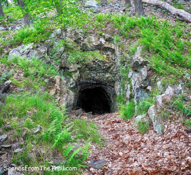
At the crest of the hill, about 100 feet from the bridle path is the location of the mine. The Edison Mine consists of a downward-sloping shaft that extends thirty-six feet in a northeasterly direction. The shaft opening at the surface measures eighteen feet by eleven feet and the maximum vertical depth is ten feet.
Edison Mine
This mine was an exploratory venture and was not operated commercially.

Edison Mine
We took a short break here and then began bushwacking east to join up with the Cornell Mine Trail. It was an easy bushwack as the area was not overgrown.

bushwacking
In about 550 feet, we reached the Cornell Mine Trail and turned right, heading south.

Cornell Mine Trail
The trail continues on a somewhat moderate grade and then it begins a steep, unrelenting ascent of Bald Mountain.

Cornell Mine Trail
We stopped frequently to catch our breath and then kept going. After all, this mountain wasn’t going to climb itself. According to the book, Iron Mines Trails, there are some mine openings along the trail on the way up, but we missed them. After a hard climb on the rocky trail, we arrived at the terminus of the Cornell Mine Trail.

terminus of the Cornell Mine Trail
We turned right onto the red-dot-on-white-blazed Ramapo-Dunderberg (R-D) Trail. This section of the trail was blazed in January and February 1921 by E. Cecil Earle and A.B. Malcolmson of the Tramp and Trail Club and J. Ashton Allis of AMC. The trail ascends gently (as compared to the Cornell Mine Trail), as it nears the summit of Bald Mountain.

Ramapo-Dunderberg Trail
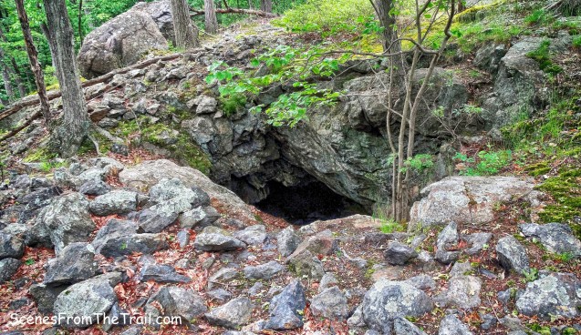
After a short distance, the trail bears left, but we continued straight, leaving the R-D Trail and bushwacking about 150 feet along the hillside. Here we came to the Cornell Mine, according to William J. Myles this mine opening was probably dug prior to 1859.
Cornell Mine
This adit or shaft opening is five feet by five feet and extends into the hillside about fifty feet; it should not be entered, as it contains water and is dangerous.

Cornell Mine
After spending a little time examining the Cornell Mine, we retraced our steps back to the R-D Trail and continued up to the summit. After climbing approximately 1100 feet, reaching the summit felt triumphant.

summit of Bald Mountain
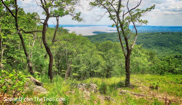
Looking north from the summit of Bald Mountain, we were rewarded with a tremendous view of the Hudson River and beyond. The Bear Mountain Bridge with Anthony’s Nose to the right is quite a sight to see from this vantage point.

view north from the summit of Bald Mountain
Just over 2 miles away, on the summit of Bear Mountain, Perkins Memorial Tower was clearly visible.

Perkins Memorial Tower
The rolling hills of Bear Mountain and Harriman State Parks, with West Mountain on the left and Bear Mountain on the far right.

rolling hills of Bear Mountain and Harriman State Parks
We were in no hurry to leave this wonderful spot that we worked so hard to get to. We found some nice flat rocks to sit on and enjoyed a sandwich with a nice cold beverage. I always freeze a couple of sports drinks on warmer days and today was one of those. Once we relaxed for quite a while, we began to descend Bald Mountain on the R-D Trail. It was steep in some spots, but for the most part it was relatively easy.

Ramapo-Dunderberg Trail
In about 3/4 of a mile, we arrived at a junction with the white-blazed 1777 Trail and the red-dot-on-white-blazes of the Ramapo-Dunderberg Trail. We stopped here to discuss whether we would turn right on the 1777 Trail and head back towards Doodletown or continue up to The Timp.

junction with the 1777 Trail and the R-D Trail
We were all exhausted at this point and to be perfectly honest, I would have been fine with doing the shorter hike. After some contemplation, we figured that since we were here, we might as well do the longer hike. We rested for a few minutes and then resumed our trek. The R-D Trail begins to climb as we made our way to the summit of The Timp. Once near the summit, there are partially obstructed views looking southeast towards the Hudson River and Haverstraw Bay.
southern view from The Timp
A little more climbing and we finally got to the summit of The Timp. There were a few groups of people there enjoying the view and we found a comfortable spot and took a load off. The view from here was pretty spectacular as the breeze cooled us off.

view from The Timp
Looking northwest, I spotted the West Mountain Shelter which we had visited back in April.

West Mountain Shelter
My calf was sore so we rested longer than I would have liked. I didn’t want to cramp up and we still had about 3 miles to go. I guzzled a sports drink and we headed out. We began to descend via the R-D Trail and turned right on the unmarked Timp Pass Road. Timp Pass Road was marked with red plaques as a ski trail by the Youth Conservation Corps in 1980. It turned out that it was too long, and in places, too dangerous. In 1987, this ski trail was officially de-marked. This “stone road,” for much of its distance, is a real “ankle-breaker.”

Timp Pass Road
We were looking for a footpath on the left that leads to a woods road. That woods road leads to the Herbert Mine. We missed it, but found another road further down that would have been our return route from the mine. We began to walk up the hill on that woods road, but it got real steep, real fast. Upon consulting the map, we determined that visiting that mine would require us climbing another several hundred feet. It didn’t take much convincing to skip that. We descended the hill back to Timp Pass Road and turned left. In a short distance we reached the white-blazed 1777 Trail. The 1777 Trail marks the route taken by British troops under Sir Henry Clinton on October 6, 1777 from Stony Point to attack the American forces at Fort Clinton and Fort Montgomery.

1777 Trail
Now in Doodletown, we passed by a small stone shelter. This is a remnant of a camp that was maintained there until the 1950’s by Riverside Church of New York City.

small stone shelter
We headed back to the 1777 Trail also known as Pleasant Valley Road, passing a 200 year Oak tree……..

200 year Oak tree
and the ruins of numerous homes, with not much left but foundations and stone steps.

Doodletown ruins
We turned right onto another woods road and walked a short distance to the Herbert Cemetery. A “sign” indicating its location is located at the intersection.
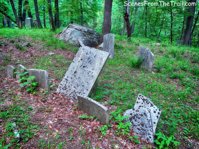
Herbert Cemetery
We retraced our steps back to the 1777 Trail which in a short distance divides into the 1777W Trail, which leaves to the left and the 1777E Trail which continues ahead on Pleasant Valley Road. We proceeded ahead, now following the 1777E blazes. Reaching a T-intersection, where Pleasant Valley Road ends, we turned right, still following the 1777E blazes, but now on Doodletown Road.

1777E Trail/Doodletown Road
We stayed on Doodletown Road and walked by the Doodletown Reservoir. Built in 1975, it was designed to supply drinking water to Iona Island and to serve as a backup to the Bear Mountain supply.
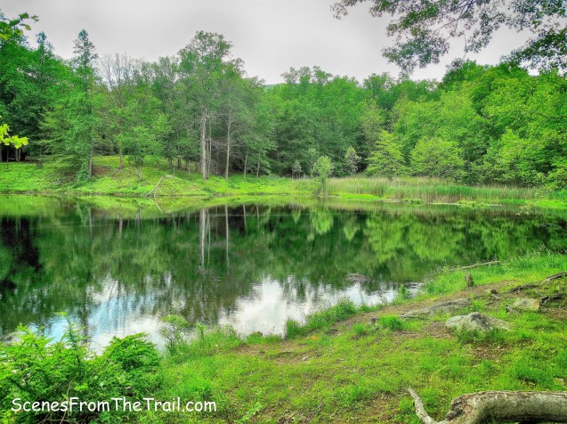
Doodletown Reservoir
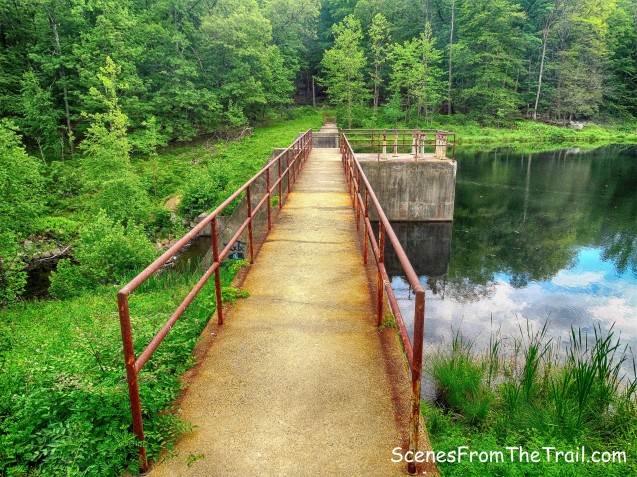
Doodletown Reservoir dam
There are more points of interest to explore in this area, but by this time we were pretty wiped out. We just continued down Doodletown Road, stopping briefly to look at some ruins alongside the road.

Doodletown ruins
Just ahead, the 1777E Trail leaves to the left, but we continued along Doodletown Road (now unmarked), which begins a steady descent.

Doodletown Road
The blue-blazed Cornell Mine Trail joins from the left as we continued to follow the road downhill. It makes a sharp right turn and then narrows to a footpath. After descending wooden steps, the trail ends at Route 9W, just north of the parking area where we began the hike.
What a great, but exhausting hike. I am glad that we did the longer version, but the shorter hike is more manageable. My only regret is that fatigue set in and we bypassed several points of interest. I hope that you enjoyed the hike and please don’t forget to follow my blog, now get out there and take a hike!
Pros: Scenic views, waterfall, secluded trails, woods roads, historic ruins, abandoned iron mines, old cemetery.
Cons: Lots of elevation gain, rugged terrain – ankle breaker trails.

Take a hike!

How long did it take you to complete the hike?
LikeLike
Approximately 4 and 1/2 hours of moving time.
LikeLike
My name is Tom Rose . I lived in Doodle town during 56 57. 58 and spent a lot of time in and out of town. Knew everyone there and still remember houses they had.To we teens Bald Mt. Was at the end of Pleasant Valley adjacent to the Stalters junkyard. Had a 10\10\10 hole on top. Jim Hurley lived next Then Chauncey and Marie Pease. Fines next and my family in the Tamson house by the big oak all on the north side of P V Rd.
LikeLike
A minor point but I have descended the trail I think you are describing from Doodletown east to 9W and have yet to encounter the “wooden steps”. Sounds as if you’ve placed them about where the rattlesnake warning sign is. Am I missing something like an alternative route?
LikeLike
The wooden steps, where the trail ends at Route 9W, is just north of the parking area where the hike began.
LikeLike