January 21, 2017 – Town of Cortlandt, NY
Difficulty: moderate
Length: approximately 2.5 miles
Route type: up and back
Map: Google Earth or Google Maps
After publishing a post about Hudson Valley Fire Towers, I was contacted by a reader named Ben with information about a fire tower that lay in ruins alongside the Croton Reservoir. I was intrigued and knew that I had to check it out. Ben supplied me with enough information that I knew I could find my way to it. I wanted to do this hike the previous week, but some light snow fell and since we would be hiking on unblazed trails, I decided to wait until the snow melted. The weather for this Saturday morning hike was foggy in the morning, but sunny in the afternoon and in the mid to high 30’s, not bad for January.
The Nelson Mountain Fire Tower sits at the summit of Salt Hill and was a 73′ Aermotor LS40 tower erected by the Conservation Department in 1950. This tower was placed in service in 1951, reporting 22 fires and 70 visitors. With the advent of aerial detection, this tower was closed at the end of the 1971 season. Some time following that date, the tower was cut down or pulled over by persons unknown and its twisted remains are still on the 540 ft. summit of Salt Hill. That was all the information I could gather about this fire tower along with an old black and white photograph courtesy of the Westchester County Historical Society.

Nelson Mountain Fire Tower at Salt Hill
I was also able to find a list of the keepers that were employed during its operation.

list of keepers
We parked alongside Croton Avenue and proceeded to the trailhead using the GPS coordinates that I was provided. Although we began there, upon our return I determined that a much easier way to the trail was alongside a stone wall which is visible from the road which leads right to the trail. Nevertheless, we bushwacked through the woods and up the hill looking for any sign of a trail. We came to a stone wall and walked through the collapsed section.

stone wall
We continued pass the stone wall and veered left. Going straight would have been an extremely steep climb up the mountain so using common sense I figured any trail would have skirted around the shoulder of the hill. As we walked through the woods, we saw some red blazes on trees and I was pretty sure this was the trail we were looking for. I was told that the trail was unblazed, but as long as this red-blazed trail led us uphill, I knew we were going in the right direction.
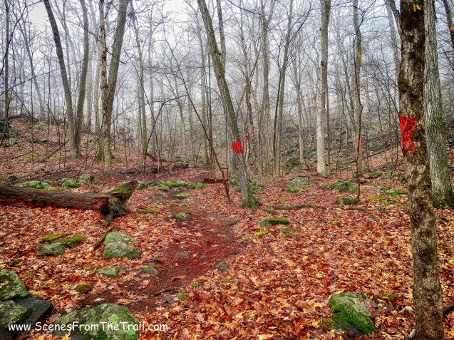
red-blazed trail
Surprisingly this trail is well maintained, which was evident by the blowdowns being cleared from the trail. I noticed tire tracks on the trail so I guess that bikers use and maintain this trail.

red-blazed trail
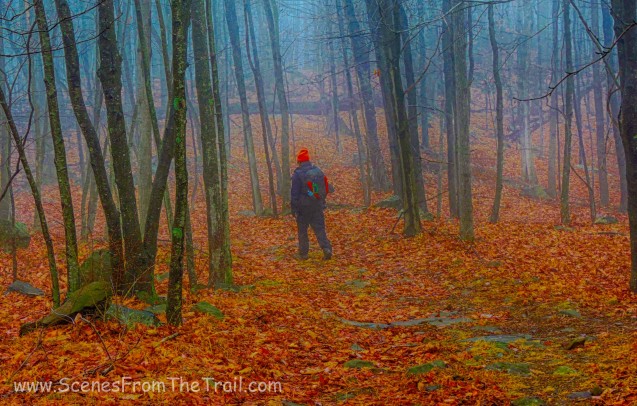
The trail led up the mountain on switchbacks and steeply in some spots, but we kept huffing and puffing towards the summit. It was foggy, serene and quite scenic. We didn’t encounter another living soul during this hike. No wildlife was to be seen or even any birds chirping. It was eerily quiet and I loved it.

red-blazed trail
At one point the red blazes started to lead away from the summit and we stopped following them. The trail though unblazed was clearly discernible until we neared the summit. The trail petered out, but thanks to Ben I knew that would happen. We walked along the ridge hoping to catch a glimpse of what we were looking for. The dense fog made for poor visibility, but I noticed a rectangular shape through the woods. I thought it might be the ruins of a building, but as I neared it I realized that it was the top of the fire tower.

Nelson Mountain Fire Tower

Nelson Mountain Fire Tower

Nelson Mountain Fire Tower
If a fire tower falls in the woods, does it make any noise?

Nelson Mountain Fire Tower
It was pretty cool to see something that was pretty well hidden in the woods and that I had no clue existed. I grew up fishing in the area and have driven by Salt Hill countless times, never knowing what sat atop the summit. Thanks Ben. We explored the area and found a large cinder block building nearby. I do not know the origins of this building, but I can guess that it was possibly used for storage.

cinder block building

cinder block building
There was a lot of evidence of human activity in the immediate area that we checked out. There were a lot of steel barrels strewn about the area.

steel barrels
There were ruins of other small buildings as well.

building ruins
When we were done exploring, we retraced our steps back to the red-blazed trail and headed down the mountain. When we got to the spot where we originally found the red-blazed trail, we stayed on it. Croton Avenue was visible through the trees and it was an easier route as well. The red-blazed trail began to parallel Croton Avenue and began to lead away from where we wanted to go. At this point we left the trail and bushwacked towards the road. We came to a lower section of the stone wall that we encountered at the beginning of the hike and passed through it.

stone wall
We made our way to Croton Avenue, turning left and walked along the road back to where we had parked. We then drove over to Turkey Mountain Nature Preserve for part 2 of our Saturday hike. I hope that you enjoyed today’s hike and don’t forget to follow my blog. As always any comments and/or suggestions are welcome and feel free to share my posts with your friends. Until next time folks, now get out there and take a hike!
Pros: Scenic area, historical features, fire tower, ruins, secluded and quiet.
Cons: Limited views
Take a hike!

Do you happen to have the GPS track from the hike up?
LikeLike
Sorry I don’t, but the coordinates of the tower are 41.247496, -73.860557.
LikeLike
Salt Hill was owned by a man named John Nelson for a great deal of time. Nelson was apparently the last of the “scroungehounds” in the area. This meaning he used to gather a lot of junk and supplies which he would use for construction and even other things, explaining the random barrels and whatever else you might find. Any weird out of place trails and clearings can be explained by Nelson’s constant logging. There used to be a mill on the property where Nelson would prepare wood for sale. He used to sell wood to supply the creation for hulls on ships by the military. He was rejected multiple times cause of “green wood,” indicating he probably milled all his wood from his property, and from his property alone. There is a main access road that you can follow down from the towers summit to a different entrance for the land of Salt Hill. There you will pass Nelson’s man made lake, I believe they named it, “Blue Lake” on the maps. Surrounding this, you’ll find there are multiple foundations. These were to small summer cottages which Nelson would rent out in the summer time, he built them himself. The Fire Tower was erected by the state which was given permission by Nelson to use his land. The weird “storage” building you refer to was Nelson’s “chapel,” where at one time an out of tune organ once resided. The other structure could have been the cottage where the keeper lived.The tower was the second tallest in its zone (second to Ninham Fire Tower in Kent N.Y.). The tower apparently held no name while it was active. It can only be assumed that after Nelson passed, they named the records for the tower after him.
LikeLiked by 1 person
I met a young couple who lived in the fire tower cabin back in 1970 or 71. The guy said he refused the military draft and as an alternative was assigned to the tower. Not sure if that was true or not but that’s the story they told. We used to ride our dirt bikes all they way up to the tower.
Bob Anderson CHHS ’65.
LikeLike
As Bob Anderson posted, as a youngster I too rode dirt bikes in that area. On the opposite side of the road (RT. 129) was an abandoned airport (Croton air park ?) we’d gather there and cross the road and through what I can best remember as a materials mining area. Lots of open dirt, mounds and no brush whatsoever. From there we’d begin the ascent up a trail to the summit. Along the way at a somewhat lower elevation than the fire tower was a cabin that I believe the Fire Ranger lived in. I was only about 12 and was following my older brother and his friends so I wasn’t part of any of their conversations. But the highlight for me was being invited up into the tower for an absolutely stunning view of the lower Hudson Valley.
I often wondered what became of the tower and thanks to this search find now I know.
I do know that the abandoned airport was developed into a housing subdivision sometime in the 1980’s.
Great memories of my Saturday outings climbing Nelson Mountain… with a motorbike of course!
LikeLiked by 1 person
The large cinder block building was John Nelson’s whack idea for a church! Here’s a photo I took of Nelson securing the door: https://evanravitz.com/Croton/Nelson1.jpg
There’s probably the remnants of an old funky organ in there. When I lived on East Mount Airy Road in the sixties, I hiked up salt Hill hundreds of times and spent the night on top a dozen times.
LikeLike
My older brother John and I climbed up the tower in 1965 and talked with Charlie Peters, the “Fire Tower Observer”. I still have the filled-out card from the trip! I was just 11 years old and my brother was 13. So we were 2 of those 70 documented visitors that the tower had in its life. We had biked there from our home on Hunterbrook Road several miles away. Just the 2 of us. It was a steep climb up Salt Hill and to us a long ascent up those 80 feet of stairs for what now would be called children. We may have taken the hike to fulfil a Boy Scout requirement. Good times 55 years ago.
LikeLiked by 1 person
I think i first found the tower with a friend but no one was home. George and I returned after speaking with the watchman by phone.
The view from the tower was expansive. As I recall we could see NYC and other fire towers. There was a map with a sighting device so the watchman could call in the direction to the smoke.
The day we found the tower, no one was home. We wanted to know if our boy scout troop could camp there. We left a message for the watchman, and he called me that evening, He referred us to Nelson. There was a different driveable road to the top. Furnace Dock road which is on the map sounds familiar. I recall Dad driving up the hill in our VW micro bus. As I recall I had another commitment and did not get to camp there.
LikeLiked by 1 person