December 3, 2016 – Cold Spring, NY
Difficulty: strenuous
Length: approximately 6 miles
Route type: circuit
Map: East Hudson Trails
Bull Hill also known as Mount Taurus, is in the village of Cold Spring on the Hudson River in Putnam County in the State of New York. It is part of the mountain range known as the Hudson Highlands. The original name came after a bull that used to terrorize the mountain was chased by indignant inhabitants. A hunting party drove the bull over the hill. In an attempt to flee the mountaineers, the bull plunged out into space and fell down. Its broken and shapeless mass on the rocks was memorialized in the name of the mountain the bull used to haunt. Bull Hill has an extensive trail system and offers hikers sweeping views of the river and neighboring peaks from rock outcrops near its wooded 1,420-foot summit. Don’t let the name fool you. This is a mountain, not a hill.

Bull Hill as viewed from Storm King Mountain – September 15, 2018

Bull Hill (as viewed from Little Stony Point)
Northgate also known as the Cornish Estate Ruins, was purchased in 1917 by Edward Joel Cornish, then president of the National Lead Company and his wife Selina. They acquired 650 acres from a diamond merchant named Sigmund Stern. What is known is that the mansion, garage, swimming pool, gardens, and other outbuildings existed at the time of purchase by Cornish. Who designed them remains a mystery. The couple died within two weeks of each other in 1938 and the estate seems to have laid abandoned more or less since then. Central Hudson Gas and Electric bought the property in 1963 and toyed with the idea of building a power plant on nearby Breakneck Ridge. By the end of the 1960’s, the ruins of the Cornish estate became part of the newly formed Hudson Highlands State Park and are now a regular stop for hikers.

Northgate – front entrance
I have been wanting to do this hike for quite some time. In my opinion, ruins are best viewed from late fall to early spring, when the vegetation is less likely to cover them. So now it’s “ruins season” for me and I incorporated views in order to extend the length of the hike. I decided to follow the hike description from the NY/NJ Trail Conference. Most of the trails in the Hudson Highlands are on rugged terrain and this one was no exception. The temperature on this Saturday morning was in the low to mid 40’s, mostly cloudy and windy. Not bad for December, but I could have done without the wind. We arrived shortly before 9am at the Washburn Trail parking area which is along Route 9D. It is directly across from the Little Stony Point entrance.
We began by entering the trail at the north end of the parking area. In about a hundred feet we came to a junction with the blue-blazed Cornish Trail, which veered off to the left. That would be our return route, but for the first 2.3 miles of this hike we would be following the white blazes of the Washburn Trail. The trail began to ascend on an old road which was once used to access a quarry. In about a half mile we reached the quarry, which was opened in 1931 and operated by the Hudson River Stone Corporation. The quarry was abandoned in 1967.

Quarry – Washburn Trail
We entered the quarry and took a look around. We also took a brief break, the first of many along this trail. We retraced our steps back to the Washburn trail and continued up as the trail steepened. On a hike with steep climbs, I like to break it up into small milestones, otherwise it becomes arduous. The first milestone was the quarry. We continued following the white blazes, and in some instances arrows up the western slope of Bull Hill.

Washburn Trail
We arrived at a rock outcrop that looked out towards the Village of Cold Spring and the Hudson River looking south. There we took another short break as we took in the view.

view south from rock outcrop
At about 1.2 miles from the start of the hike, we came to an intersection where the yellow-blazed Undercliff Trail crosses the Washburn Trail. We decided to make a left here just to get a break from the climb uphill. There were several viewpoints along the short stretch we hiked which were not that different from the previous viewpoint, but it was a short lived mostly level walk which added about a half of a mile to our hike. We returned back to the Washburn Trail and continued to ascend until we came to a spot where there were some boulders on the left. We clambered atop of one of the boulders and were greeted with a spectacular view of Crow’s Nest Mountain to the left and Storm King Mountain to the right.

Crow’s Nest Mountain to the left and Storm King Mountain to the right
After working up a sweat, we took a break here. It was extremely windy at this point and we took refuge on a bench-like rock that sheltered us a little from the strong gusts that came from the river. We had a snack, hydrated and then we were off again. We were now ready for the final push to the top, well not really, but we didn’t have much of a choice. We got to the summit just as some other hikers were on their way down. Looking south, I could see the New York City skyline.

New York City skyline
We had just hiked about 2.5 miles and climbed 1,420 feet. That was a hard hike up, but it was all downhill from here. We began to descend on the eastern slope on switchbacks, passing several viewpoints along the way. At one such spot we could see Breakneck Ridge to the north.

Breakneck Ridge
We came to a three way junction and made a left onto the blue-blazed Notch Trail which was a rocky foot path downhill. Eventually it turned into an old woods road and much easier to walk. After a mile on the Notch Trail, we came to Breakneck Brook, where the Notch Trail turns right. At this point it is also where the red-blazed Brook Trail begins, going to the left, which was the way we were headed. First we took a detour to check out the ruins of the dairy farm where Edward Cornish raised his prized Jersey cows. The most imposing building was the stone cattle barn.
stone cattle barn

stone cattle barn
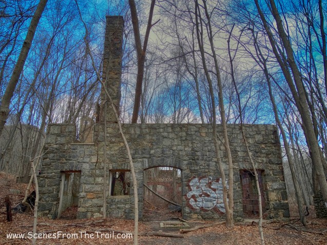
Next to the cattle barn is another stone building which I do not know what its intended purpose was.

stone building
A little further away there were several other buildings. I believe that this one was a garage.

garage
When we were done exploring these ruins, we headed towards the red-blazed Brook Trail which paralleled Breakneck Brook as it cascaded downhill. This was the most pleasant trail of the day. A nice easy descent for about a half of a mile or so. We came to a fork where the blue-blazed Cornish Trail began and we jumped on that trail. As we hiked downhill, I looked to my right and saw a siphon chamber on the Catskill Aqueduct, which we were about to cross. We took another detour so we can get a better look.

Catskill Aqueduct siphon chamber
We then retraced our steps back to the Cornish Trail and continued our descent along the now paved road. In a short distance, we arrived at the mansion ruins of the Edward Joel Cornish estate (Northgate). It’s quite an impressive set of ruins. You can view images of the estate how it appeared when it was lived in here. The main house below, was equipped with a porte-cochère (far left).

Northgate – main house
There are several chimneys that are still standing. The image below was shot facing north with Breakneck Ridge in the background.

Northgate – main house

Northgate – main house
From the main house we headed up to the greenhouse which we had passed moments before as we walked down the Cornish Trail.

Northgate – greenhouse

Northgate – greenhouse

Northgate – greenhouse
There were several other buildings nearby that we didn’t check out. To be honest I was beat up from the feet up by now and just wanted to finish up the hike. I decided to return the following day with my SLR and wide angle lens and hike up the short way to capture more images. So now we headed down the Cornish Trail on the paved road which was the original driveway of the estate.

Cornish Trail
We arrived back to the parking area at almost 3pm. We were tired and hungry so after a brief rest, we headed out to feast on some Nachos, homemade Chicken Piccata and Coconut Layer Cake. That’s right, after every hike we dine on some tasty culinary delights that we prepare ourselves. I truly hope that you enjoyed the hike and don’t forget to follow my blog if you are so inclined. Feel free to leave a comment and/or share this post with your friends. Now get out there and take a hike!

Take a hike!

Thanks for this post. I have many fond memories of this area from my youth – climbing Breakneck Ridge, camping near the pond that used to be behind the old dam just north of the Notch and Brook Trail intersection with my family and my Boy Scout Troop. This was in the late 1960’s and early 1970’s. In the mid-1970’s my girlfriend and I used to like to hike there and explore the old ruins.
I continue to enjoy your other posts as most include hikes and scenes from my youth. It’s great fun as I haven’t been back there in decades!!!
Thanks.
-Mark Leander
LikeLike
Thank you for your comments. I am glad that my blog brings back good memories. I enjoy sharing my experiences and the images captured with others. Thank you for visiting and stay tuned.
LikeLike
Great shots! I’ve been meaning to do the Cornish Estates forever as well, but I already did Bull Hill without knowing I can combine the two. I don’t want to re-summit the mountain (so many other good ones to conquer nearby), do you know approximately how long it is to do the hike in reverse, just to get to the ruins?
LikeLike
Funny you should ask. I returned to the ruins the following day, via the Cornish Trail. It’s about 1.5 miles round trip mostly along the old driveway to the estate. I did not go back to the dairy farm, which would have added about another mile (round trip) uphill. I was still recovering from Bull Hill and wanted to keep it on the easy side. My next post will be about this. Stay tuned.
LikeLike
Perfect! Thanks 🙂
LikeLike
Pingback: Cornish Estate Ruins and Little Stony Point – Scenes From The Trail
Here you go Julie, a much easier way to get there.
LikeLike