September 10, 2016 – Walpack Township – Walpack Center, NJ
Walpack , New Jersey is located in the scenic western section of Sussex County along the Delaware River. The township includes a section of the Old Mine Road, which is reputed to have been constructed by the early Dutch miners in the mid-1600s as a means of transporting copper ore from the Pahaquarry area to Kingston (formerly Esopus), NY. At one time it was considered the longest commercial road of note in the colonies. The area was sparsely settled before 1736. The 24 square mile township is peaceful and exceedingly quiet, almost to the point of being spooky.

Walpack , New Jersey
In the 1960s, in order to control damaging flooding and provide clean water to supply New York City and Philadelphia, the U.S. Army Corps of Engineers proposed building a dam. When completed, the Tocks Island Dam would have created a 37 mile long lake between Pennsylvania and New Jersey, with depths of up to 140 feet. This meant that all the homes in the area would be underwater. This lake and the land surrounding were to be organized as the Tocks Island National Recreation Area. Although the dam was never built, 72,000 acres of land were acquired by condemnation and eminent domain. The Corps and the National Park Service would end up spending $100 million to buy homes, stores and churches on either side of the river. About 8,000 people were evicted from their homes. The dam was never built and the land was subsequently transferred to the oversight of the National Park Service.

signs seen on many of the abandoned buildings
There are numerous abandoned homes and barns throughout the area that have been left to rot. Upon entering Walpack, I came upon this home alongside National Park Service Route 615 (Walpack Flatbrook Road).

along Route 615
Since these structures are overseen by the National Park Service, the grass was mowed on properties easily viewed from the road. Below are some more images for the same house.

along Route 615

along Route 615
A short drive away is Main Street, also known as Walpack Center. Although these homes are unoccupied, there seems to be some restoration being done on some of the structures. I parked across the street from the church and captured some images of the buildings which date as far back as 1850.
Walpack Methodist Church – This well built church was erected in 1872 at its present site at a cost of seven thousand dollars. Today the church is owned by the National Park Service. The Walpack Historical Society uses this facility for its general meetings.

Walpack Methodist Church
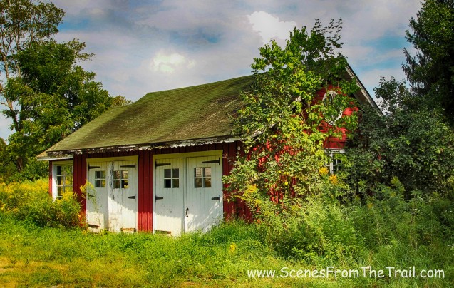
Across the street from the church is a garage with an old gas pump. To the right there is an old fire or air raid siren.

garage
Back behind the garage is the one room schoolhouse.
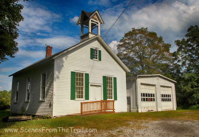
one room schoolhouse
Below are some more buildings that line Main Street in Walpack Center. Click on the ensuing images to enlarge.


I continued down Main Street and turned right onto Mountain Road. I stopped momentarily at Walpack Cemetery.

Walpack Cemetery
Just after leaving the cemetery I saw a Pheasant in the road so I stopped and was able to capture an image before he dashed into the woods.

Pheasant
Continuing down Mountain Road, I stopped at Buttermilk Falls, which is the tallest falls in the state of New Jersey. I had visited this waterfall several times before and it was quite a sight to see, but today it was nothing more than a trickle.

Buttermilk Falls
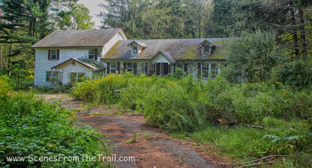
Just down the road from Buttermilk Falls was another abandoned and dilapidated house.

ruined house on Mountain Road
Away from Main Street the houses were in really bad shape. No restoration job here. Click on the ensuing images to enlarge.


I continued down the road and a short distance away was an old barn. When I pulled up there were three older women there checking out the barn. One woman told me that the barn and the house up the road (pictured above) belonged to her sister until she was forced to move.

barn on Mountain Road
The barn was huge and looked to have been squatted in at one time like most of the buildings I visited.

barn on Mountain Road
It also had a storm cellar, but I did not venture down the stairs to check it out.

storm cellar
Here’s a view of the rear of the barn.

rear of the barn
At this point I turned around and headed back towards Walpack Center. I stopped and took a few more shots before I headed out. I turned left at the end of Main Street onto Walpack Flatbrook Road (National Park Service Route 615) and saw some more abandoned houses just off the road. I pulled in the driveway to check them out.

structure alongside Walpack Flatbrook Road
Right by the barn was an overgrown basketball court.

overgrown basketball court
It looked like all these buildings shared a common driveway. A little further in was this more modern looking home.
modern looking home
I turned around and walked back past where I was parked and this red barn seemed to be in decent shape.
red barn

red barn
Across from the red barn was an old farmhouse.

old farmhouse
After checking out these structures, I was off to Old Mine Road. I had read that there was some abandoned structures along that old gravel road.
Once off the pavement and driving the gravel road, I came to what seemed like a farm. The property had numerous structures some in worse shape than others.

The main house
There were several mailboxes out front, but this newspaper box caught my eye.

newspaper box
Near the front of the property sat this structure.

outbuilding
Below are a couple of shots of the interior.
outbuilding

outbuilding
Behind the main house was a shed like structure.

shed
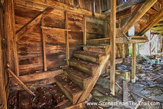
Towards the back of the property there was a large L shaped barn. It was in pretty bad shape as part of it had collapsed.

L shaped barn

L shaped barn

L shaped barn
This was a huge building and the interior was cavernous.

L shaped barn
There were signs posted on all the buildings due to the poor condition of the structures.

sign
To the left of the main house stood another small outbuilding.

small outbuilding
I drove down Old Mine Road and saw another dilapidated house.

dilapidated house
I continued driving down Old Mine Road with the Delaware River visible through the trees on my right. It was a tight squeeze anytime a vehicle came from the opposite direction. Thankfully that only happened a few times. After about 1.5 miles I arrived at the Van Campen Inn. Despite its name, the Van Campen Inn was never really used as an inn, at least not as we know them today. This “inn” was actually a “Yaugh house,” a rural house in a remote area that was required by early colonial law to provide shelter and food to travelers.

Van Campen Inn
It was an interesting day visiting a town that time forgot. I hope that you enjoyed my journey into the abandoned town of Walpack, NJ. Until next time folks……….

Very interesting pictorial information.
LikeLiked by 1 person
Thank you.I can’t wait to visit Walpac!
LikeLiked by 1 person
Love your photos, so interesting!
LikeLike
Thank you.
LikeLike
Excellent post!
The marked trail to the top of Buttermilk Falls had the worst short stretch I can think of. Very steep and slick with nothing to grab onto. If it hasn’t been rerouted, it ought to be!
LikeLike
My parents owned property in the 60s in the area which was bought by the gvt 4 the dam i was very young and dont remember alot and some of this brought back some of the memories that i do have and reading about old mine rd was interesting cause i remember taking it to our property
LikeLike
Thanks 4 the memories
LikeLike
Thanks for the photo tour of this quiet corner of northwest New Jersey.
What a shame the Park Service doesn’t encourage utilization and maintenance of some of the buildings you highlighted. The old “inn”building of stone construction could be a great youth hostel for
Visitors to the area. There are historic highlights in the region, but they are scattered and need interpretation by local citizen historians. Will explore when I get there. I am much further south in Burlington County.
LikeLike
My parents purchased land in Flatbrookville in the 1950’s. They lived there full time from the 1960 to the 1970’s. Flatbrookville is right down the road from Walpack. My Dad build his retirement home there. Shortly after Dad’s home was completed, the federal government informed him his home was going into condemnation for the Tocks Island Dam project! The government offered them about 25% of what it was worth. My parents fought the condemnation for about 10 years and were able to get paid 75% of what the home and property were worth. Mom and Dad lived next to Red and Ginny Fuller on Rt. 615 the Walpack Flatbrook Road. Red Fuller never moved or sold to the government. He and Ginny lived in their home up into the 1990’s as I visited with them there at that time. Red Fuller was the Mayor of Flatbrookville. It is interesting to note the the site the Army Corp of Engineers chose to build the dam had a huge fault under it in the ground. When an independent engineering firm surveyed and discovered this fact they reported it to Congress, the funding was pulled and the fault was later confirmed by the Army Corp of Engineers. This is a fact that seems to have gotten “Lost” in history. But it is very true! All these people lost their homes for nothing. A interesting note is: The Walpack Inn, a fantastic restaurant is open, alive and well. It is located on Rt 615 and is open mostly on weekends. They have fantastic food and the owners relatives were great friends of my parents. You can easily find the Walpack Inn on Google to get directions and operating hours. Random thoughts: We stayed at Stevens Cabins in Flatbrookville, NJ in the summers of the 1950’s right on the Delaware river. I swam across the Delaware River at Steven’s Point. I swam in the Flatbrook in Haney’s Mills hundreds of times, right off of 615. We often visited Buttermilk falls as friends of my parents lived near by right on the Flatbook. Their names were Frank and Ginny Gillespie. Camp Pocono Ramona was right across the Flatbrook up the “mountain road” in Flatbrookville and it hosted hundreds of children ever summer. Chapeau Farms was located on Rt 615 between Walpack and Flatbrookville. Frank Chapeau was the captain of our United States Equestrian Team circa 1960. Mr Haney owned and operated a saw mill on the property my parents purchased. He retired when my Dad began building. The Lombardi’s owned and operated a fantastic hardware and antique store in Walpack.
All of these people were evicted from their homes with the exception of Red Fuller who was as tenacious as a bulldog. I believe his son Glen Fuller lives today in Branchville, NJ Yes,I have many memories of Walpack Township and Flatbrookville
LikeLiked by 2 people
Wow! I can see the images of what you have described above like scenes from a movie. Our govt. can be so foolish and destructive in its actions 100 mil of taxpayers’ money and displacing people. A documentary or a short film should be made about this and other similar events of which I am sure there is no dearth. Could they not have determined the presence of a massive fault before moving forward with the project? Such facts are deliberately omitted from the history to save the asses of incompetent people in the govt. Back in that period of time, I suppose they could get away with this sort of stuff very easily. I was looking up the Walpack Inn and came upon this blog. Now I really want to visit this place. Wondering how to find someone to show me around, any suggestions? Thanks for the very interesting historical information! 👌🙏
LikeLike
Thanks for sharing. I just discovered that my ancestors (Schoonover & Swartwout) settled and lived in this area in the 16-1700’s. What a shame to see such historic buildings left to ruin! I will have to make an effort to visit the area cemetery before it too is lost to history!!
LikeLike