August 20, 2016 – Garrison, NY
Difficulty: easy
Length: approximately 4 miles
Route type: circuit
Map: East Hudson Trails Map #101
Arden Point is a peninsula on the Hudson River in the hamlet of Garrison, Town of Philipstown, Putnam County, NY. Approximately 17 acres lie west of the Metro North railroad with another 21 acres east of the tracks. Access is provided along Lower Station Road and from the Metro North station parking lot at Garrison. A wooded trail that snakes along the eastern banks of the Hudson River eventually leads to a rocky bluff known as Arden Point with river views north and south, including a full view of West Point on the opposite shore.
Glenclyffe is a 93-acre parcel of land on the Hudson River in the Highlands, which is preserved through the efforts of the Open Space Institute and its partners. Benedict Arnold rode through it trying to escape to the British. New York Governor Hamilton Fish, later to become Secretary of State under President Ulysses Grant, lived on it. Grant and President Abraham Lincoln both visited it.
On a hot and humid August day I was looking to do a hike that had some shady trails, views and level terrain. This hike fit the bill quite nicely. As far as I’m concerned any hike that includes walking along the shore of the Hudson River is always pleasurable. I decided to do the hike described in the NY/NJ Trail Conference’s website. It was a good call because this hike had everything that I was seeking and more.
We parked at the Garrison Metro North Station which offers free parking on weekends. The trailhead is just to the left of the entrance to the lot and we were off.

Arden Point trailhead
We headed south on a blue blazed shady woods road that was level.

blue blazed shady woods road
After a few minutes we passed an old railing on the right side of the trail.

old railing
Just past the railing were some ruins of several buildings. I could not find out any information online as to what these buildings were. If anyone has any info on their history please comment below. Below are some shots that I took.

Arden Point ruins
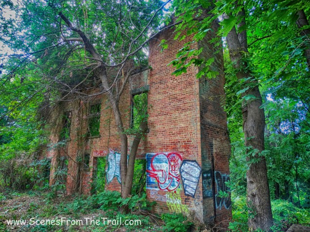
Arden Point ruins

Arden Point ruins

Arden Point ruins
Just past the ruins we crossed a footbridge and continued on the relatively straight and level trail.

footbridge
After about a half mile from the start of the hike we came upon a steel truss bridge. We crossed the bridge over the railroad tracks towards the Hudson River.

steel truss bridge
When we crossed over the bridge there were two female hikers that were somewhat lost so I let them take a look at my East Hudson Trails Map and then we continued on. At the end of the bridge we kept following the blue blazed trail which went to the right.

blue blazed trail
The trail was now a footpath and there were some blow downs along the way. A minor inconvenience and not hard to get around.

blowdown on blue blazed trail

blowdown on blue blazed trail
The blue trail ended at a junction with the red trail and we now started following the red markers staying to the right. We walked through the break in a stone wall……

stone wall
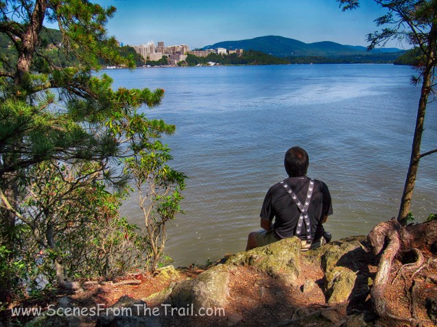
and then moments later we arrived at Arden Point North with a view of West Point to the left and Bull Hill towards the center.

Arden Point North
It was nice and breezy by the river and we hung out enjoying the view and the cool summer river breeze. As we relaxed there for a while, a few dog walkers and a family of hikers appeared on the scene. I just continued to gaze at the boats and jet skis as they raced along the river. Below are some more images captured at this lookout. Click on the ensuing images to enlarge.


When we were ready to continue we retraced our steps back to the red trail, this time heading south. At times we lost the red markers and bushwacked through the woods. I wasn’t concerned, I knew that keeping the river at my right shoulder would lead us south which was our intended route. We found the red blazes, but several times throughout this section of the hike we bushwacked until we once again met up with the red trail. We arrived at Arden Point South and took in the southern views towards the Bear Mountain Bridge. Click on the ensuing images to enlarge.


Once done enjoying the view and the cool river breeze, we headed back onto the red trail which proceeded to lead us uphill and back to the steel truss bridge over the tracks. Once we crossed back over the bridge we turned right and briefly followed the white blazed trail until we came to the Open Space Institute (OSI) red blazed trail. This was the start of the Glenclyffe Loop, which circles the Glenclyffe property of OSI. Shortly we came to a gazebo with obstructed views of the river. The trail passes just to the left of it.

gazebo
As we hiked through the woods, we came to a red brick building on the left that was built in the 1860s. It was once the home of Hamilton Fish who was the governor of NY.

home of Hamilton Fish
We captured some images of the former governor’s home.

home of Hamilton Fish

home of Hamilton Fish
As we continued following the red blazes of the Glenclyffe Loop we came to a sign that pointed towards the Historic Overlook.

sign
We made our way to the overlook where there was a viewing platform that overlooked the site of Beverly Dock, which was used in 1780 by Benedict Arnold to escape when his treason was discovered. I would take some caution on this platform because the railings were loose and it sits over a steep drop off .

viewing platform
After leaving the Historic Overlook we continued on the red trail. This section of the trail was where Benedict Arnold rode through to escape.

Benedict Arnold’s escape route
We passed by a couple of ponds and dams along the way and then came out onto an open field alongside Route 9D.

open field
We walked along the treeline which was marked with red blazes. Across 9D, Castle Rock was visible up on the hill.
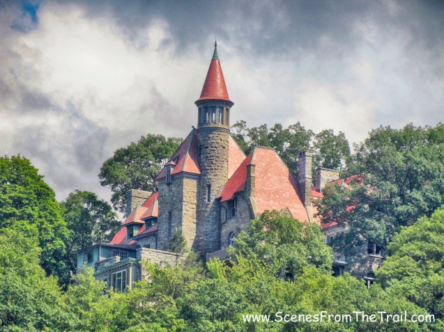
Castle Rock
At the sign for the Garrison Institute we turned left and walked up to a trail map that signified the beginning of the white blazed Marcia’s Mile trail.

trail map
We followed the white blazes through the woods and a field and we passed the ruins of a small structure.
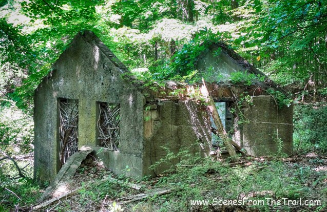
ruins
As we hiked through the woods we saw some wooden crosses staked into the ground that seemed like a shrine. I have no idea what they represented, but it felt a little creepy seeing them in the woods. It may have something to do with Marcia, seeing as the trail is named after her.

wooden crosses

wooden crosses
At the end of Marcia’s Mile we came to the steel truss bridge that we had crossed twice earlier and we turned right where we retraced our steps back to the Garrison Metro North lot.

blue trail heading north
I hope you enjoyed today’s hike, and don’t forget to follow my blog to stay informed about my latest journeys. Until next time, keep on trekking…….
keep on trekking

Thanks for the step-by-step! I’ll be in town this weekend and am looking forward to hiking it!
LikeLike
You’re welcome, it’s a really nice hike along the Hudson with some ruins thrown in for good measure. Enjoy it.
LikeLike
Was there a map you downloaded and followed.
LikeLike
I updated the post and included the link for the map that I followed.
LikeLike
Thank you for this! We’re going to do this one soon and this really helpful =)
LikeLike
You’re welcome, enjoy.
LikeLike
Hi! My sister and I hiked this trail this past weekend. We came across a place that said “No Public Access”, although we lost track of the red markers and accidentally wandered in that area looking for the next marker. We came across what looked like an altar of some sort with symbols that we weren’t very familiar with, but that looked like they could have Christian associations. Did you see this place too? I’ve been searching online, but cannot find anything about it, and I can’t seem to identify two of the symbols.
LikeLike
You may have wandered onto the grounds of the Garrison Institute. https://www.garrisoninstitute.org/
LikeLike
The ruins along the trail was once a convent on grounds owned by the Capuchin Franciscan Order. My uncle, with permission from his superiors, allowed me, my mother, and father to move into the abandoned, but intact building, to help us relocate from Yonkers to “the country”. My father and grandfather, a carpenter and Irish immigrant, created a livable space in the old convent. The rest of the place consisted of old, long empty rooms (referred to as “cells”).
Ironically, as a teenager, I attended Glenclyffe High School, in the former Hamilton Fish home, which had been converted into a minor seminary for boys intending to become Capuchin priests.
We believed that the ghost of Mrs. Fish roamed her former home every night like Lady Macbeth
LikeLike